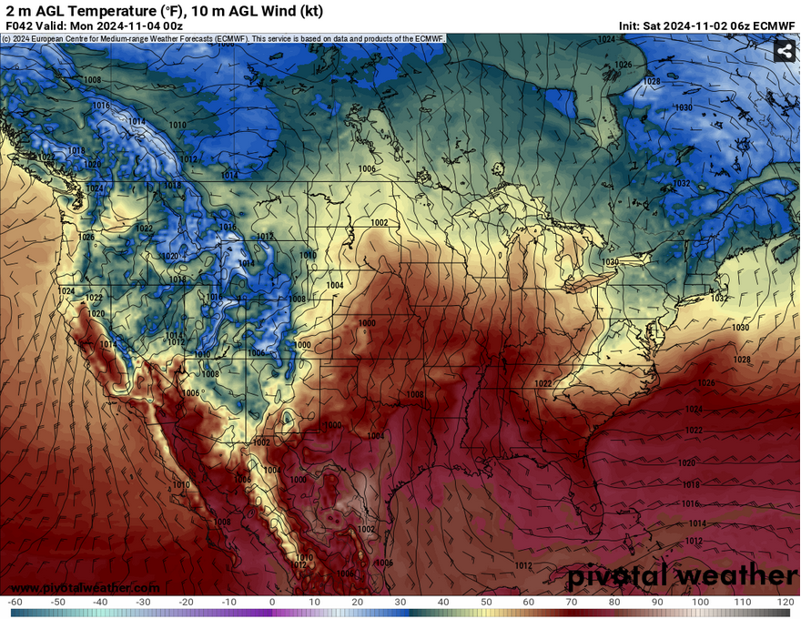
Moving into November, you might notice that’s it’s quite warm for this time of year. That likely won’t change for a while since we have a strong southern influence from a surface high out east and a low pressure system in the plains. All in all, warm, slightly humid, and windy as the weekend progresses.
Today, we’ll have some mid and high level clouds meandering across the south with the cold front passing through. Most of these will remain through the day and move out by tonight with some east winds at the surface. Highs will be in the mid 80s with conditions just sticky enough to be felt, but not miserable. Overnight, lows will reach the low 60s with the winds shifting towards the southeast.


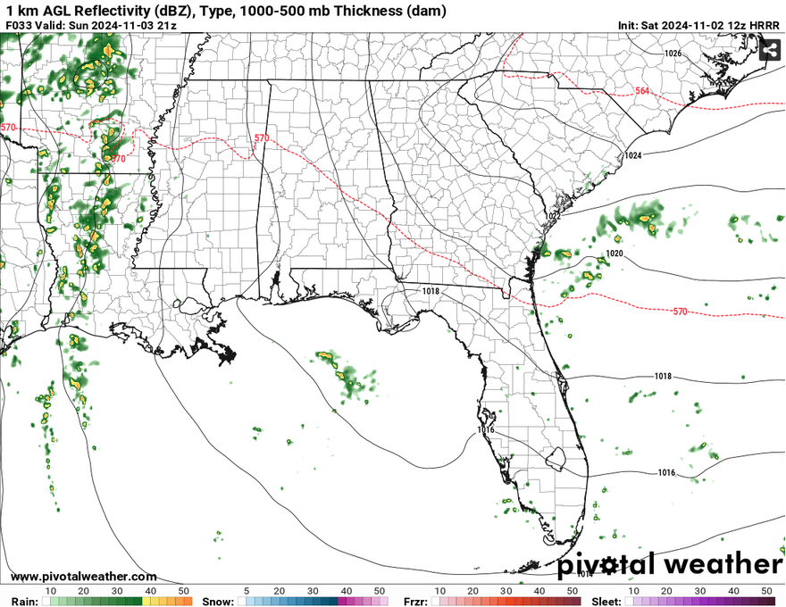
Sunday will be warm and slightly muggy for Mississippi and Alabama while rainy across Louisiana and Arkansas. The low pressure system in the northern Plains is helping to feed the Gulf moisture across much of the western part of the Deep South bringing rain across the region. Temperatures will reach the mid 80s across the board before dipping into the 70s for the western half as it rains. Considering the gradient, some gusty winds can’t be ruled out across much of the Deep South as well.
Moving into Monday, we’ll see some low level clouds across parts of coastal Mississippi and Louisiana contributing to some of the humidity. The clouds will help reduce the overall temperature across much of the area into the low 80s, but we’ll also see some higher winds moving from the south and southeast during the day. A very slight chance of rain is also possible. Overnight, we’ll only fall into the mid 60s overnight.
The Tropics
Yes, the tropics are still active this time of year, hence why Hurricane season is all the way to the end of November. We have two systems in the Caribbean as well as the Leeward Islands to look at. First off is 17AL, which is located north of the Greater Antilles. This system is slightly organized and will likely bring heavy rain and wind for much of the islands, but it will likely be merged into the larger low, AL97.

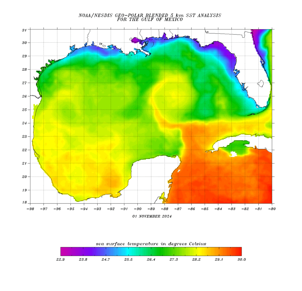
AL97 has more of a path to go, but just needs more organizing. Most of the spaghetti plots point it towards the southern Gulf and finding its way afterwards. One trend I noticed is that it looks like it’ll meander a bit in the Gulf before deciding which way it wants to go. I wouldn’t be surprised if it follows that stream of warm water in the middle of the Gulf before deciding which way it’ll go, and depending on the next mid-latitude cyclone’s strength may have an influence on which direction it’ll head in. So far, the Euro model has it following the warm water towards northeastern Mexico, while the GFS points it towards our neck of the woods and the Canadian model moves it towards Florida. Most of the spaghetti plots lean it towards mid to strong tropical storm status, but if it moves towards us, it may have an effect on our current drought, but let’s not get too ahead of ourselves yet.
I’ll have another update tomorrow as we get more information on AL97. For now, have a great weekend!
Select Data Set:

Regional Day-to-Day Forecast
This Afternoon – Mostly sunny, with a high in the mid to upper 80s. East southeast wind around 5 mph.
Tonight – Mostly clear, with a low in the low 60s. Southeast wind around 5 mph becoming calm.
Sunday – Mostly sunny, with a high in the mid 80s. East southeast wind 5 to 15 mph, with gusts as high as 20 mph.
Sunday Night – Partly cloudy, with a low in the mid 60s. Southeast wind around 10 mph, with gusts as high as 20 mph.
Monday – Partly sunny, with a high in the low 80s. Southeast wind 10 to 15 mph, with gusts as high as 25 mph.
Monday Night – Partly cloudy, with a low in the mid 60s. Southeast wind 5 to 10 mph, with gusts as high as 20 mph.
Tuesday – A 30 percent chance of showers in the afternoon. Mostly sunny, with a high in the low to mid 80s. South southeast wind 5 to 10 mph, with gusts as high as 20 mph.
Tuesday Night – A 20 percent chance of showers. Mostly cloudy, with a low in the mid 60s. South southeast wind around 5 mph becoming calm after midnight.
Wednesday – A 30 percent chance of showers, mainly in the afternoon. Partly sunny, with a high in the low to mid 80s. Calm wind becoming east around 5 mph in the morning.
Wednesday Night – A 20 percent chance of showers. Partly cloudy, with a low in the mid 60s.
Thursday – A 20 percent chance of showers and thunderstorms. Mostly sunny, with a high in the low 80s.
Thursday Night – A 20 percent chance of showers. Partly cloudy, with a low in the low 60s.
Friday – A 20 percent chance of showers. Mostly sunny, with a high in the mid 70s.

