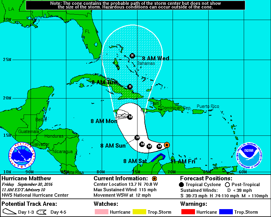
As we wrote the other day, hurricane intensity is a tough thing to forecast. Even with localized wind shear around Matthew and only warm – but not extreemely warm – water under it, the storm grea overnight into a Category 3 storm.
Here is the latest from the National Hurricane Center:
Most of the forecast models indicate the storm will slow and eventually turn north toward Jamaica and Cuba. The trough to the south of the Gulf of Mexico should keep Matthew away from the Gulf Coast states, but folks in Florida and along the East Coast (specifically the Carolinas, Virginia, Maryland, and Delaware) should continue to keep an eye on this storm.
More from the NHC:
At 1100 AM EDT (1500 UTC), the center of Hurricane Matthew was
located near latitude 13.7 North, longitude 70.8 West. Matthew is
moving toward the west-southwest near 12 mph (19 km/h). A westward
motion at a slower forward speed is expected later today and
tonight. A turn toward the west-northwest is forecast by Saturday
night, followed by a turn toward the northwest by early Sunday. On
the forecast track, the center of Matthew will pass north of the
Guajira Peninsula later today and tonight and remain over the
central Caribbean Sea through early Sunday.Data from an Air Force Reserve Hurricane Hunter aircraft indicate
that maximum sustained winds have increased to near 115 mph (185
km/h) with higher gusts. Matthew is a category 3 hurricane on the
Saffir-Simpson Hurricane Wind Scale. Little change in strength is
forecast during the next 48 hours.Hurricane-force winds extend outward up to 35 miles (55 km) from the
center and tropical-storm-force winds extend outward up to 195 miles
(315 km).The latest minimum central pressure based on data from the aircraft
is 968 mb (28.59 inches).


