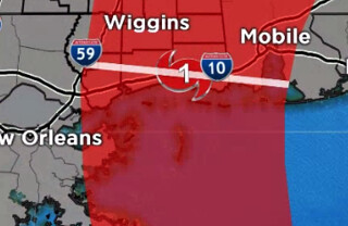
10:00 AM UPDATE: Nate now a strong Category 1 hurricane.

9:30 AM ORIGINAL: Hurricane Nate continues to cruise – at speeds around 20mph – to the north across the Gulf of Mexico. It seems to be in quite the hurry. The reason for the full head of steam is it is sandwiched between a gyre to the southwest and an area of high pressure to the east. Both are creating a lot of southerly push in the corridor Nate is moving through right now.
The Latest
Hurricane Nate is a – robust – Category 1 storm with wind at 85mph. It is moving north-northwest at 22mph.It is forecast to make landfall somewhere along the Louisiana, Mississippi or Alabama coast late tonight and into early tomorrow morning.

Everyone from New Orleans, Louisiana east to Pensacola, Florida needs to be prepared for hurricane conditions. When it makes landfall it is forecast to have sustained wind speeds around 90mph with gusts approaching 110mph. Most of the wind associated with Nate is on the east side of the storm. Due to its forward momentum, the structure on the west side of the storm isn’t as well-defined and the wind speeds aren’t as high.
In fact, there is a pretty dramatic drop-off for hurricane-force wind, and tropical storm-force wind on the west side of the storm.
The storm will slow down slightly when it moves ashore, but not much, and not for long. It will start to speed up once it gets north to about I-20 as it gets picked up by a cold front.
Look for the landfall to be between 12:30 am and 2:00 am late tonight and into early tomorrow morning.
It could get a bit stronger
I bet we get another five to 10 mph out of Nate before it finally peaks as it moves ashore. Latest satellite imagery shows the storm with good outflow aloft, a tighetning core and high, cold cloud tops near the center.
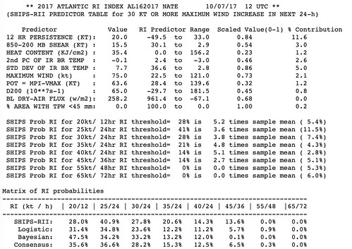
The SHIPS model shows the possibility of more intensification.

Other model guidance is split 70% / 30% with 70 percent of the models showing data to suggest it remains a high-end Category 1 storm. So we will have to watch the next two updates to see what happens.
From the National Hurricane Center
An Air Force reconnaissance plane investigated Nate a couple of
hours ago and measured peak flight-level winds of 89 kt at 850 mb
to the east of the center. No hurricane force winds were reported
west of the center. The SFMR winds from that mission yielded an
initial intensity of 70 kt. Since the plane left, the satellite
presentation has changed little, so the winds remains with the same
value in this advisory. Another reconnaissance plane is currently
approaching Nate.The outflow is well established suggesting that the shear is low,
while the atmospheric conditions favor some additional
strengthening. On this basis, the NHC forecast calls for some slight
increase in the winds, however, the SHIPS/LGEM models forecast Nate
to be a little bit stronger just before landfall. After landfall,
weakening is anticipated and Nate is forecast to dissipate in 96
hours or sooner.Nate is moving rapidly toward the north-northwest at about 19 kt.
The hurricane is being steered by the flow between a large cyclonic
gyre over the southwestern Gulf of Mexico and a developing mid-level
ridge over the western Atlantic. This pattern should continue to
force Nate on a general north-northwest fast track for the next 24
hours. After that time, the hurricane will recurve northeastward
with additional increase in forward speed as it encounters the
mid-latitude westerlies. The NHC track forecast has not changed much
from the previous one and is and is very close the HFIP corrected
consensus HCCA. This model has been very skillful this season.
For my South Mississippi friends
As this moves shore you can expect the following conditions…
Simpson, Smith, Lawrence, Walthall counties: Rain and wind (gusts up to 45mph)
Jeff Davis, Covington, Marion counties: Heavy rain (up to 2″) and wind (gusts up to 60mph)
Jasper, Clarke, Wayne, Jones, Lamar counties: Very heavy rain (up to 4″), wind (gusts to 75mph) and a few isolated tornadoes
Forrest, Perry, Greene and Pearl River counties: Very heavy rain (up to 5″), wind (gusts to 85mph) and a few isolated tornadoes
Stone and George counties: Very heavy rain (up to 6″), wind (gusts to 105mph) and a few isolated tornadoes
The weather will start to go downhill as early as 9pm tonight, and last through about noon Sunday.

