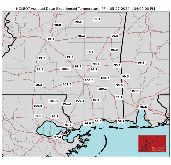
We are experiencing another hot afternoon on this Memorial Day with temperatures in the 90s for most of the region. However, when you factor in the sun, the humidity, and the wind, it may feel closer to 100F.
There is a slight chance of thunderstorms this evening, however, any additional storm potential will likely be suppressed to areas roughly south of the Highway 84 corridor due to subsidence and drying aloft after overnight storms. There’s a Marginal Risk (1 out of 5) for severe storms in that area, but it’s conditional on sufficient lift for isolated storm development. If storms develop, they could become intense with damaging wind gusts possible. Keep an eye on the sky when driving home from your Memorial Day plans.
Tuesday will be hot and dry with highs in the 90s, so be sure to drink plenty of water and limit outdoor activity. A slow-moving cold front is forecasted to move through during the day, filtering in less humid air. Most of the area should stay dry with greater rain chances back across western Louisiana. For Wednesday, we might see isolated to scattered storms during the afternoon hours, but it will quickly exit the region by the evening.
We are confident that temperatures will be slightly cooler (keyword: slightly) through the end of the workweek with highs in the 80s and lows in the 60s. During this timeframe, there are chances for isolated to scattered showers, but the severe threat will be on the lower side. Saturday could bring more widespread showers and storms to the area.
A warming trend looks to start back up again by Sunday and Monday, so enjoy the “cooler” weather while you can.
REGIONAL DAY TO DAY FORECAST
Tonight: Mostly clear with a slight chance of showers and thunderstorms in the evening, then partly cloudy after midnight. Patchy fog after midnight. Lows in the lower 70s. Southwest winds around 5 mph in the evening, becoming light and variable. Chance of rain 20 percent.
Tuesday: Patchy fog in the morning. Sunny. Highs in the mid 90s. Northeast winds around 5 mph.
Tuesday Night: Mostly clear in the evening, then becoming partly cloudy. Lows in the upper 60s. Southwest winds around 5 mph in the evening, becoming light and variable.
Wednesday: Mostly sunny. A slight chance of showers and thunderstorms in the afternoon. Highs in the lower 90s. Northeast winds around 5 mph, becoming southeast around 5 mph in the afternoon. Chance of rain 20 percent.
Wednesday Night: Mostly cloudy. Lows in the upper 60s.
Thursday: Mostly sunny. A slight chance of showers and thunderstorms in the afternoon. Highs in the upper 80s. Chance of rain 20 percent.
Thursday Night: Partly cloudy. Lows in the mid 60s.
Friday: Mostly sunny. A slight chance of showers and thunderstorms in the afternoon. Highs in the upper 80s. Chance of rain 20 percent.
Friday Night: Partly cloudy. Lows in the mid 60s.
Saturday: Mostly sunny. A chance of showers and thunderstorms in the afternoon. Highs in the upper 80s. Chance of rain 30 percent.
Saturday Night: Partly cloudy with a slight chance of showers and thunderstorms. Lows in the upper 60s. Chance of rain 20 percent.
Sunday: Mostly sunny. A slight chance of showers and thunderstorms in the morning, then a chance of showers and thunderstorms in the afternoon. Highs in the upper 80s. Chance of rain 30 percent.


