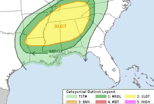
Passing showers and storms this morning will be possible, mainly along I-20 where a little cluster of storms fired up this morning before sunrise. These storms are non severe and likely elevated in nature as they are riding right along the front.
The chance for rain will continue today with showers here and there. A lot like yesterday, this won’t be an ‘all day’ rain, but we can’t rule out a shower to develop and pass over any given point today. So if you have outdoor plans, make sure those plans include a way to duck inside to avoid getting drenched should one of these showers cruise by you.
You can almost think of today like a Summer day. Chance for rain, but it will probably be dry for most of the day.
I’ve still got eyes on what it coming down the pipe for Saturday. The forecast isn’t “locked in” by any means, but we are starting to get a better idea about how things will shake out.

So far, it looks like the worst of the weather should stay north of I-20. Again. The poor folks across Arkansas, northern Mississippi, northern Alabama, and Tennessee don’t need any more severe weather, but, sadly, that looks to be on the menu.
Down here, we will continue to monitor the chance for very heavy rain, frequent lightning, wind gusts up to 60mph, small hail and the potential for a brief and weak tornado.

I’ve highlighted three reasons SVR threat looks lower farther south on the graphic above. First, the wind shear looks more like ‘speed shear’ than ‘directional shear’ meaning the hodograph in the upper right corner doesn’t have much arching to it.
Second, the 850mb to 500mb temp difference is ‘marginal’ for cool season, often we need more than 12C at 850mb and -10C at 500mb. In fact, I can count on one hand the number of times there has been severe weather in the region and the temperature at 500mb has been warmer than -10C. So, that’s a bit of good news.
Lastly, the Downdraft CAPE values are below 600 J/Kg. And about 600 J/Kg seems to be the ‘magic number’ around this region for stronger tornado development. We can see tornadoes will less than 600, but usually those are EF0s and EF1s.
Things can change! So please keep up with the forecast. But for the moment, while there is the potential for severe weather, it doesn’t look like the threat is very high at the moment.
Today
Partly cloudy with a few showers and storms possible. Highs around 80. Breezy. Southwest winds 15 to 20 mph. The chance of rain 30-percent.
Tonight
Partly cloudy. Patchy fog after midnight. Lows in the upper 60s.
Friday
Mostly cloudy with a 30-percent chance of showers and storms. Highs around 80.
Friday Night
Partly cloudy. Lows in the upper 60s.
New Years Day
Mostly cloudy with storms likely. Some may be severe. Highs in the upper 70s. Breezy. South winds 10 to 15 mph with gusts to near 30 mph. The chance of rain 80-percent.
Saturday Night
Storms possible still. Partly cloudy after the storms pass. Cooler. Lows in the upper 40s. The chance of rain 60-percent.
Sunday
Partly cloudy. Much cooler. Highs in the lower 50s.
Sunday Night
Mostly clear. Colder. Lows around 30.
Monday
Sunny. Highs around 50.
Monday Night
Mostly clear. Lows around 30.
Tuesday
Mostly sunny. Highs in the upper 50s.
Tuesday Night
Partly cloudy. Warmer. Lows in the lower 40s.
Wednesday
Partly cloudy. Highs in the upper 60s.

