Happy Thursday, everyone! It’s almost the weekend and temperatures are still hot outside due to high pressure overhead. Thankfully, this pattern will begin to break down as we head toward this weekend with a shortwave trough moving through, bringing a chance of rain to most of the region. Rainfall totals should be under an inch for many, so continue to water the plants and grass.
Hot Weather for the Rest of the Week
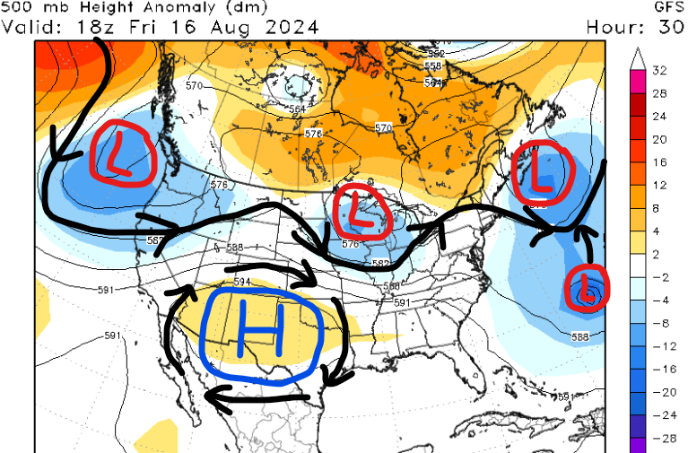
Our current pattern across the U.S. features several interesting features. First, a mid-level shortwave trough is moving across the northern CONUS, bringing an increase in cloud cover and rain chances to the Ohio Valley and Northeast. Also, high pressure is over the southwest U.S., so above-average temperatures are still over much of the southern states. Finally, we have Hurricane Ernesto which is forecasted to impact Bermuda early this weekend with a hurricane warning in effect.
So what does all of this mean for our region? Before that trough to the north makes its way closer to us, high pressure will continue to influence our weather. This causes a lot of sinking and dry air, especially since we’re on the eastern side of it. Furthermore, less cloud cover helps our surface temperatures climb above average for this time of year.
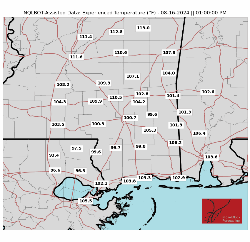

For tomorrow and Saturday, high temperatures are forecasted to be in the mid to upper 90s across most of the region. Not only will surface temperatures be warm, but it’ll be pretty humid out there this weekend, especially along the coast. Factoring in moisture and sunlight, heat indices could top 110 degrees tomorrow along and north of I-20.
Cities such as Jackson MS, Collins, MS, and Meridian, MS are some of the locations that will truly feel the heat tomorrow between 11 am and 4 pm.
We recommend limiting your time outside during peak hours, especially those prone to heat illness. Also, please drink plenty of water and don’t leave children or pets in your car while it’s shut off.
Rain Possible This Weekend
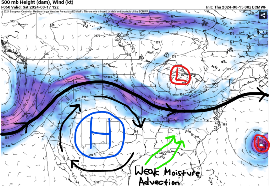
This weekend, rain will be possible as a shortwave trough traverses the eastern CONUS. Out ahead of it, moisture advection and forcing won’t be the best due to the high pressure off to our west. Regardless, some moisture will advect northward and bring a few afternoon clouds to the area. There will still be plenty of sunshine for a lot of the region and not everyone could see rain each day.
The best chances for rain look to be between Saturday and Sunday evening as a cold front will start to slow down as it moves toward the southeast. Some storms could be on the stronger side on Saturday with gusty winds being the main concern.
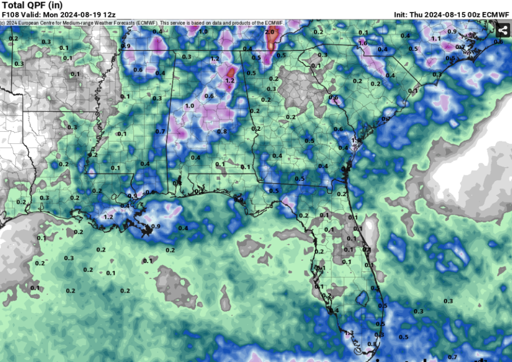
This will not be a washout as most locations should stay under an inch of rainfall this weekend. Better chances to see greater than 1” will be closer to the coast and near the state of Alabama. The area could benefit from this rain due to the dry pattern we’ve had the past couple of weeks.
Finally, one more quick shot of rain is possible Monday afternoon for our region, but confidence is still low regarding this situation. What we’re more confident in is a dry stretch the rest of next week due to a more northerly flow.
Pattern Change Late Next Week?
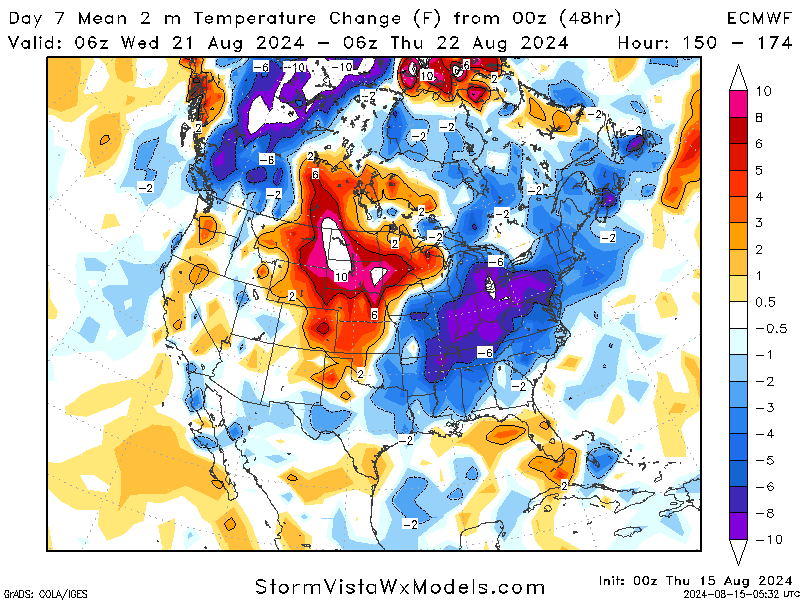
Heading into the middle of next week, ridging is forecasted to dominate the plains region, bringing above-average temperatures and higher humidity values. Afternoon highs could be 10 to 15 degrees above average.
Further east, a large mid to upper-level trough is forecasted to dip into the Ohio Valley. With this setup, cold dry air from the north will drop southward, so high temperatures will be average or even below average across much of the eastern CONUS. Not only will temperatures be slightly cooler, but dew points should be much lower. This will make it feel more comfortable outside, so if you live in this part of the country, I’d recommend making outdoor plans late next week.
For our region, locations further north will feel this slight cooldown more as areas along the coast should stay hot and humid. We’ll have more details on this pattern change this weekend from Seth!
Quick Tropical Update
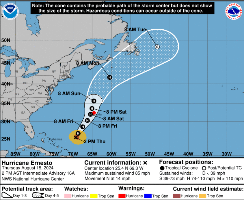
As of this afternoon, Hurricane Ernesto has wind speeds of 85 mph with a gradual change in intensification over the next 24 to 48 hours. The two reasons why Ernesto didn’t intensify more last night was because of some dry air filtering in and the system staying more broad instead of tightening up.
A hurricane warning is now in effect for Bermuda as the latest forecast takes the center very close to the island as a category 2 hurricane. Storm surge, heavy rainfall, destructive winds, and power outages are all likely this weekend. It is rare for Bermuda to have a direct hit, so please take this storm seriously and listen to local officials if you’re in the path of this storm.


