I hope you all had a great week! This afternoon, a weak cold front is forecasted to move through, bringing a chance of storms during the afternoon and evening hours. After that, drier and hotter weather is likely due to high pressure building in, so be sure to get outside on Sunday before the heat returns next week. Also, Tropical Depression Four will likely become Tropical Storm Debby this afternoon, bringing impacts to Florida, Georgia, and the Carolina’s over the next few days.
Rain This Afternoon
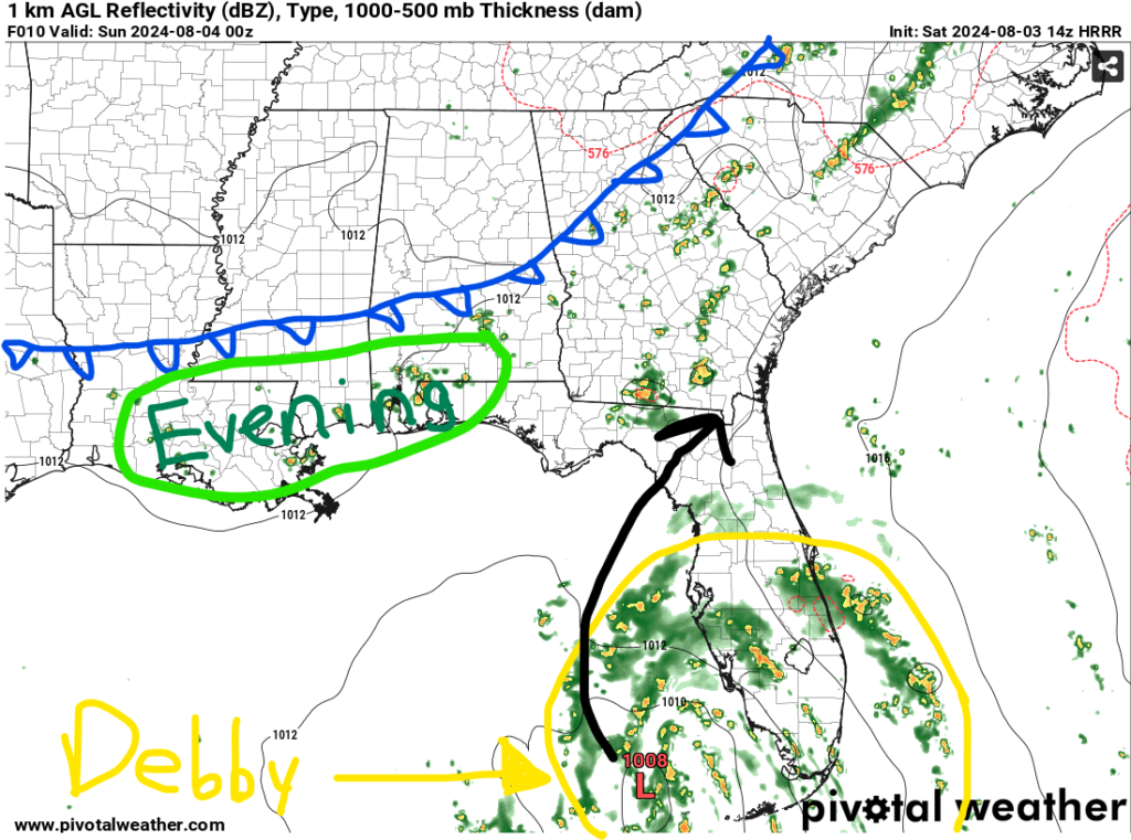
Today, we are tracking an area of low pressure across the Mid-Atlantic. This will drag a cold front into our region by the afternoon, allowing for showers and thunderstorms to develop out ahead of it. Some storms could be on the stronger side with heavy rain, gusty winds, and lightning being the main concerns. Not everyone will see rain today as better chances look to be along the coast.
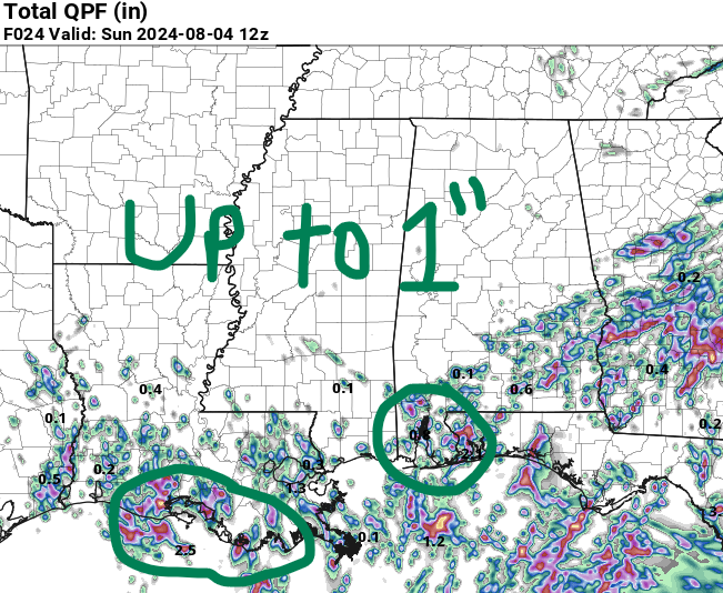
Timing for this rain looks to be between 4 pm and midnight with a few showers possible after that. The best chance for over 0.5″ of rain will be in eastern Louisiana, southern Mississippi, and southern Alabama with some locations exceeding 1″.
A few showers are possible on Sunday due to the front slowing down, but most areas should stay dry. Once again, right along the coast is where you’ll have to best opportunity to see rain Sunday afternoon, but it won’t last too long.
Hot & Dry Next Week
Unfortunately, the cold front isn’t going to do much to our temperatures, so we’ll continue to stay near average by the beginning of next week as high temperatures will be in the 90s.
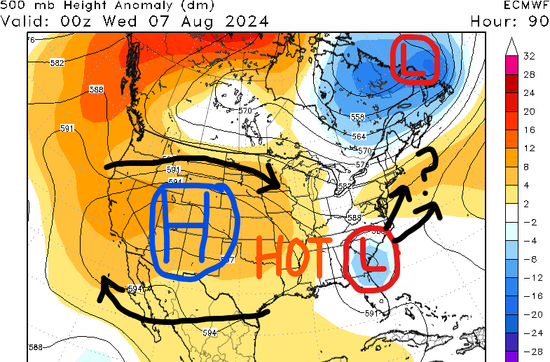
Looking at the 500mb map on the left, the first main story is “soon to be” Tropical Storm Debby which will likely be impacting Florida, Georgia, and the Carolinas late this weekend into early next week. As of now, that system looks to stay to our east. So what will our weather be like compared to the areas that’ll be affected by Debby? HOT and DRY.
A strong area of high pressure is slowly forecasted to build in across most of the country next week. Being on the east side of this high negates us from seeing “return flow” out of the Gulf of Mexico, so our moisture source will be cut off in the mid-levels of the atmosphere. High pressure allowing for a lot of sinking air which is why we are forecasting less rain chances for the first half of next week at least. Less cloud cover is also likely, allowing for the surface to heat quickly.
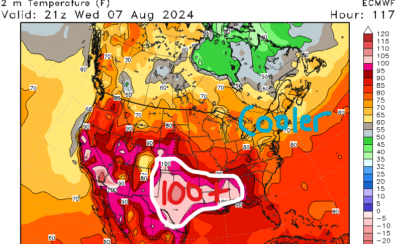
As the aforementioned high shifts to the east, our region will be underneath it, so temperatures are going to be above average with temperatures in the mid to upper 90s and heat indices above 110 degrees. Confidence is increasing that high temperatures above 100F are possible mid to late next week, especially along I-20.
Cities such as Jackson, MS, McComb, MS, Hattiesburg, MS, Meridian, MS, and Mobile, AL could feel like 110 degrees on Monday and Tuesday. Try to avoid going outside from 11 am to 3 pm, drink plenty of water, and apply sunscreen to exposed areas if you have to be out.
Unfortunately, the heat is forecasted to be around until at least next weekend with little to no rainfall possible. We will update you next week of when we can expect a pattern shift.
Tropical Depression 4
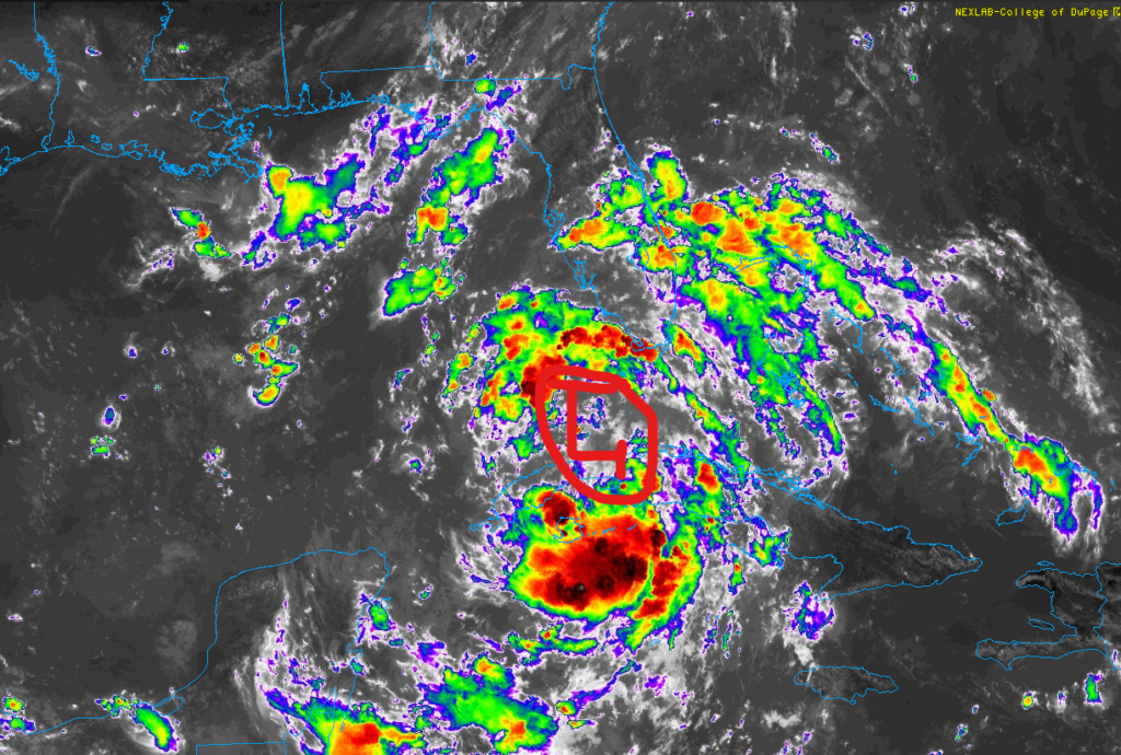
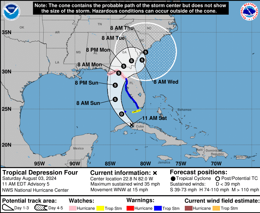
Tropical Depression Four is currently just north of Cuba and is starting to get it’s act together. Now that we have more of an idea of where the center of circulation is, models are beginning to show tighter spread and have more agreement going into next week.
Confidence is leaning towards a landfall in northern Florida in the Gulf as a tropical storm or weak hurricane. A slower forward motion for TD4 or a shift further west could make this a stronger storm, so continue to check the latest forecast posted here.
If you live along the coast, especially in southern Mississippi and southern Alabama, we would recommend making preparations in case the storm track does shift further west.
Rough surf is possible for our area along the coast, so be sure to avoid going in the ocean, especially on Sunday because of the rip current risk. Southern Alabama would be closest to the storm, so locations such as Gulf Shores should pay attention to local officials to see if it’s safe to be out on the water Sunday.
Heavy rain will be the main story with soon to be Tropical Storm Debby as locations in Florida could pick up over 6″ of rain this weekend and early next week. Models are showing that 10+” of rain is certainly possible for Georgia and the Carolina coastlines due to Debby stalling and dumping torrential rainfall. I will have a full breakdown of Debby and the rest of the tropics tomorrow evening!


