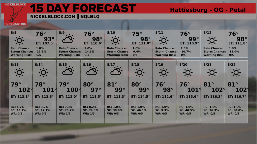
Happy Thursday, everyone! Hot and dry weather will continue for our area the rest of the week as high pressure sits over the southern CONUS. This pattern should remain the same heading into next week, so rain chances will be on the lower side over the next seven days. Some of us may see an afternoon shower or thunderstorm next week, but it shouldn’t be a complete washout.
Hot the Rest of the Week
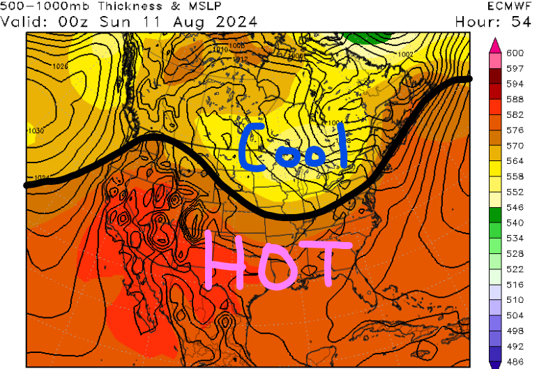
High pressure has been stuck over our area for the past couple of days as temperatures continue to run above average. While much of the southeast was socked in cloud cover from Hurricane Debby, our region has stayed mostly sunny with high temperatures in the 90s.
While our mid to upper-level flow may weaken the rest of the week, high pressure at the surface will continue to dominate over parts of Texas. Being on the eastern side of the high, dry air will filter down from the north and limit rain chances. Furthermore, the sinking air will continue to limit upward motion in the atmosphere, so limited cloud cover is likely for the rest of the week.
While we’re dealing with the heat, locations further northward may have an early taste of fall this weekend due to a strong cold front passing through the Upper Midwest and Northeast.
A slight drop in dew points is possible for our region, but the cold front won’t allow us to escape the heat. You would have to go north of I-20 where dew points could be in the low 60s this weekend across northern Mississippi.
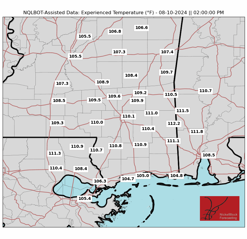

High temperatures the rest of the week and this weekend look to be in the mid to upper 90s due to the atmosphere heating up faster with more sunshine present. Heat indices could exceed 110 degrees in some locations, especially near the coast such as Mobile, AL or Biloxi, MS.
Limit time outdoors, especially during the early afternoon hours as heat illness can occur quickly. Find shaded areas if you have to go outside and take frequent hydration breaks. I’d recommend getting your outdoor chores done early in the morning or late in the evening. Finally, do not leave your children or pets in the car without it running. The inside of the car can heat up rapidly in just minutes!
Next Week’s Pattern
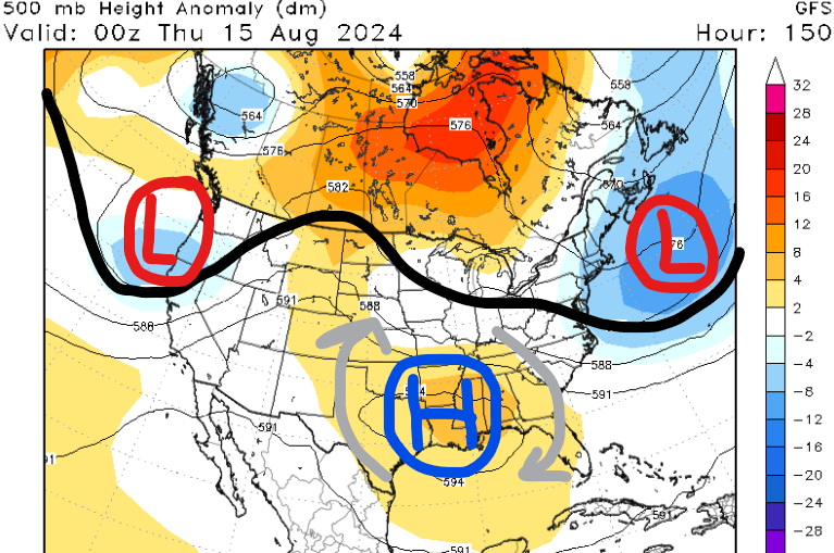
Unfortunately, we aren’t forecasting much of a change in temperatures or precipitation over the next 1-2 weeks. High temperatures should remain slightly above average and models are showing that our region has the best odds of seeing limited rain chances for next week. High pressure is forecasted to build in overhead by the middle of next week, so heat indices will likely exceed 110 degrees in some locations.
In fact, much of the U.S. will likely be above average in temperatures, and not many places will see widespread rainfall either. A higher likelihood of precipitation looks to be across Hispaniola and the Bahamas due to a potential tropical wave.
The only true rain chances we’ll see are the typical afternoon showers and thunderstorms that are closer to the coast. If this dry pattern continues, then we may need to be concerned about wildfires due to the decrease in our region’s fuel moisture levels.
What you should be focusing on with this graphic is the consistency in above-average temperatures and below-average precipitation over the next two weeks. We’ll keep you up-to-date on when we can expect a pattern change for our region.
Quick Tropical Update
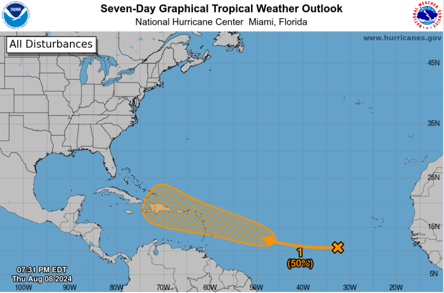
We are continuing to track Tropical Depression Debby which has one more round of heavy rainfall for the eastern CONUS. Flooding is likely across portions of the Northeast through Saturday before the system gets picked up by a cold front and pushes it out to sea.
After Debby, there is a new wave in the main development region over the open Atlantic. This area will continue to track off to the west-northwest over the next few days as the NHC gives it a 50% chance of formation.
The Lesser Antilles, Puerto Rico, and Hispaniola could be dealing with impacts by next week. After that, models are still inconsistent on whether this system becomes a fish storm or not.


