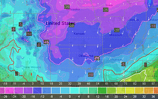
Simpsons references aside, if you live west of Chicago and north of San Antonio, get the extra blankets out. The southern plains are about to get whalluped with cold air tonight. After the current system moves to the east, the clouds will begin to thin out and eventually clear in some areas meaning the area is primed for some sub-zero temperatures.

As it looks right now, most of the computer weather models are suggesting lows tonight near zero across most of Oklahoma and the Texas panhandle, with some areas of Kansas easily sliding below zero.
While certain models, like the RUC for example, want to break out widespread below 10-degree temperatures from St. Louis to Wichita to Oklahoma City to Lubbock. And north of that line, plenty of below-zero temperatures commonplace across most of the western counties of the southern plains.
According to the RUC, at midnight(!!), plenty of places will be at or below zero. Places like Amarillo and Kansas City.
There are a few reasons the area will get so cold.
1. The biggest player is the chunk of cold air that slid south out of Canada (the national media will blame the “Polar Vortex” like it is some big storm responsible for this, but that isn’t completely true).
2. The precipitation that blanketed the area will act as an insulator overnight to trap all of the “heat” at the surface, keeping it out of the atmosphere.
3. The skies will clear out – only partially in some areas – and the winds will calm down, allowing the atmosphere to radiate all of the heat back away from the ground.
While the RUC and the NAM are definitely the coldest for a lot of the southern high plains, even the GFS is onboard with widespread temperatures around zero. And, hey, even the ECMWF suggests temperatures in the single digits for most of the area. So any way you slice it, it is going to be cold. Bring the pets inside and bundle up!

