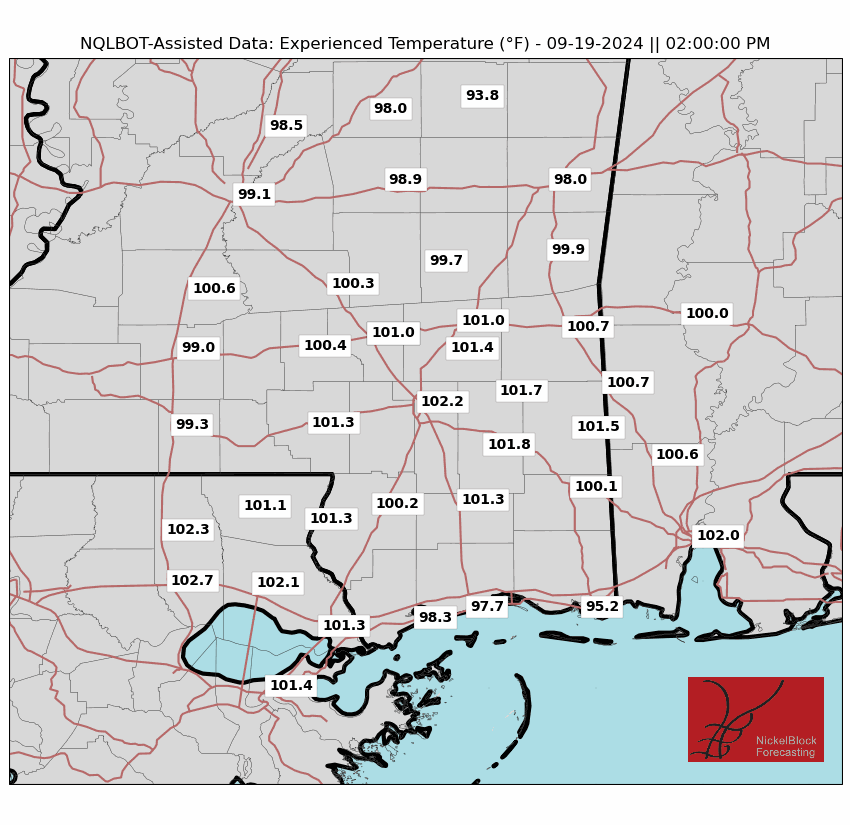
It’s going to be a bit warmer and more humid today. This morning, we saw some clouds moving in from the southwest, but they won’t stop temperatures from reaching the mid-90s in most areas. That will push the “Experienced Temperatures” (when we factor in sun intensity, wind, and humidity to let you know what your body will think it feels like walking around) to around 110F today.
With the added moisture and daytime heat, expect isolated to scattered showers and thunderstorms this afternoon, mainly along and south of I-20. The northern fringes of the area should stay dry.
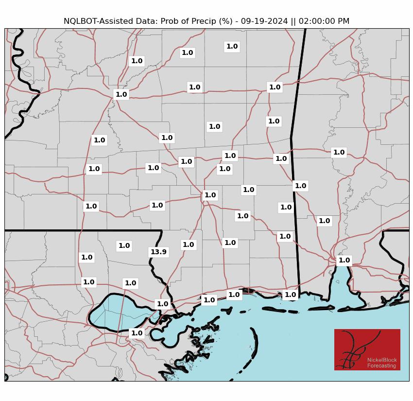
While the AI-assisted weather maps keep most of the area dry, I tend to think we will see storms. This is one place I think the humans still have the computers beat. These storms may linger into the early evening before fading. Tonight’s lows will be in the mid 70s, slightly warmer than normal, but nothing too terrible.
This weekend, expect temperatures and humidity to rise as high pressure builds in. Temperatures will reach the upper 90s. A heat advisory will likely be needed, with heat index values (how hot it feels) between 105-110 degrees.
Early next week, Gulf moisture will move northward, raising humidity levels even more. Heat index values could exceed 110 degrees for some spots. This means we’ll likely need excessive heat warnings. There will be more chances for afternoon showers and thunderstorms, but it will still be very hot before any rain starts.
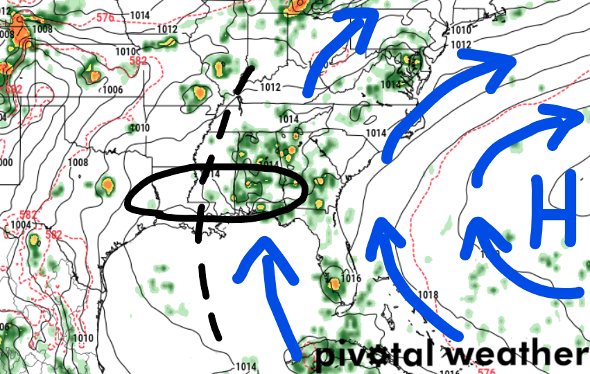
And I have some question about just how much Gulf moisture we will see to spark off extra storms. I tend to think we will be sitting on the periphery of the influence of the ridging. That means the push of air from teh south may be enough to make it more humid, but not enough to give us a meaningful boost to offer extra afternoon storms.
By late next week, a weather pattern shift may bring some “less hot” weather, but it is July, so “less hot” is still plenty warm.
REGIONAL DAY TO DAY FORECAST
Today: Sunny. A chance of showers and thunderstorms this afternoon. Highs in the mid 90s. Northwest winds around 5 mph, becoming southwest this afternoon. Chance of rain 40 percent. Heat index values up to 105.
Tonight: Partly cloudy with a slight chance of showers and thunderstorms in the evening, then mostly clear after midnight. Lows in the lower 70s. Southwest winds around 5 mph in the evening, becoming light and variable. Chance of rain 20 percent.
Saturday: Sunny. A chance of showers and thunderstorms in the afternoon. Humid with highs in the mid 90s. Light and variable winds, becoming south around 5 mph in the afternoon. Chance of rain 30 percent. Heat index values up to 109.
Saturday Night: Partly cloudy in the evening, then becoming mostly clear. Humid with lows in the mid 70s. Southwest winds around 5 mph in the evening, becoming light and variable.
Sunday: Sunny. Showers and thunderstorms likely in the afternoon. Humid with highs in the mid 90s. Temperature falling into the lower 90s in the afternoon. Northwest winds around 5 mph, becoming south in the afternoon. Chance of rain 60 percent. Heat index values up to 110.
Sunday Night: Partly cloudy in the evening, then clearing. Lows in the mid 70s.
Monday: Mostly sunny. A slight chance of showers and thunderstorms in the morning, then a chance of showers and thunderstorms in the afternoon. Highs in the mid 90s. Chance of rain 50 percent. Heat index values up to 110.
Monday Night: Partly cloudy in the evening, then mostly clear with a slight chance of showers and thunderstorms after midnight. Lows in the mid 70s. Chance of rain 20 percent. Heat index values up to 105 early in the evening.
Tuesday: Mostly sunny. A slight chance of showers and thunderstorms in the morning, then a chance of showers and thunderstorms in the afternoon. Highs in the mid 90s. Chance of rain 50 percent. Heat index values up to 110.
Tuesday Night: Partly cloudy in the evening, then clearing. A slight chance of showers and thunderstorms. Lows in the mid 70s. Chance of rain 20 percent. Heat index values up to 105 early in the evening.
Wednesday: Mostly sunny. A slight chance of showers and thunderstorms in the morning, then a chance of showers and thunderstorms in the afternoon. Highs in the mid 90s. Chance of rain 50 percent. Heat index values up to 110.
Wednesday Night: Partly cloudy with a slight chance of showers and thunderstorms. Lows in the mid 70s. Chance of rain 20 percent. Heat index values up to 105 early in the evening.
Thursday: Mostly sunny. A slight chance of showers and thunderstorms in the morning, then showers and thunderstorms likely in the afternoon. Highs in the mid 90s. Chance of rain 70 percent. Heat index values up to 110.


