Some folks are waking up a bit soggy this morning. And we have some lingering showers across southwestern Mississippi and southeastern Louisiana. We will have another shot for showers and storms this afternoon – with, I think, a low=end brief tornado risk, too.

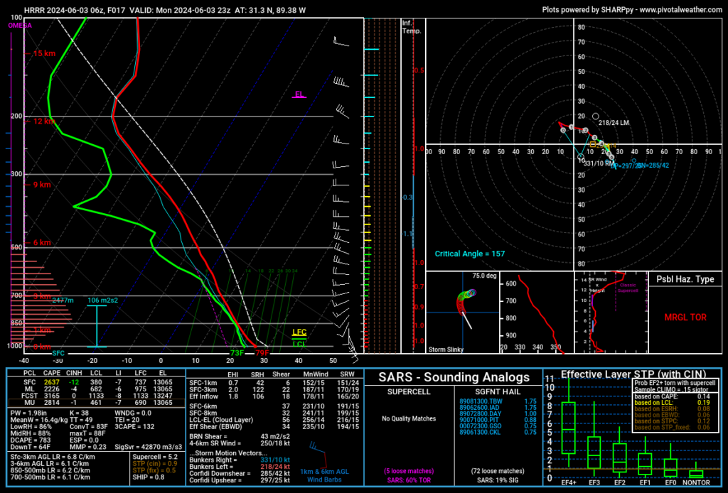
The model guidnace from the 6z HRRR model suggests a brief window for surface-based weakly rotating storms. If we get the correct type of boundary intersection, we may be able to squeeze out a brief tornado. It is a pretty low risk, but it isn’t zero on a day like today. Plus, with the available moisture levels, don’t be surprised if you see scary-looking or low-hanging clouds, too.
Another storm system forming over western Kansas is expected to reach our area later this afternoon or evening, although the exact timing and location are uncertain. It looks like we may see some storms fire up ahead of the MCS this afternoon along lingering outflow boundaries from storms overnight and showers this morning. The highest risk for severe weather is generally west of I-55, where damaging wind gusts and quarter-sized hail are possible.
The main cluster of storms should weaken as they move east tonight due to decreasing instability, but they could still spread across the state.
After that, we stay in an active “Northwest Flow” pattern where afternoon storms that develop in the Plains dive to the southeast and across our area Tuesday and Wednesday. And perhaps Thursday, too.
This weekend, high pressure will shift east, reducing storm chances, but isolated storms are still possible due to elevated moisture levels. Early next week, the bulk of storm activity is expected to move towards Texas as the moisture axis shifts west.
REGIONAL DAY TO DAY FORECAST
Today: Mostly sunny. A chance of showers and thunderstorms this afternoon. Highs around 90. Southeast winds around 5 mph. Chance of rain 50 percent.
Tonight: Partly cloudy. A slight chance of showers and thunderstorms in the evening. Lows in the lower 70s. South winds around 5 mph. Chance of rain 20 percent.
Tuesday: Mostly sunny. A chance of showers and thunderstorms in the afternoon. Highs around 90. South winds 5 to 10 mph. Chance of rain 40 percent.
Tuesday Night: Mostly clear in the evening, then becoming partly cloudy. Lows in the lower 70s. South winds 5 to 10 mph.
Wednesday: Mostly sunny. A chance of showers and thunderstorms in the afternoon. Highs in the lower 90s. South winds 5 to 10 mph. Chance of rain 30 percent.
Wednesday Night: Partly cloudy with a chance of showers and thunderstorms in the evening, then mostly cloudy with a slight chance of showers and thunderstorms after midnight. Lows in the lower 70s. Chance of rain 30 percent.
Thursday: Mostly sunny. A slight chance of showers and thunderstorms in the morning, then a chance of showers and thunderstorms in the afternoon. Highs in the lower 90s. Chance of rain 40 percent.
Thursday Night: Mostly clear. A slight chance of showers and thunderstorms in the evening. Lows around 70. Chance of rain 20 percent.
Friday: Sunny. A slight chance of showers and thunderstorms in the morning, then a chance of showers and thunderstorms in the afternoon. Highs in the mid 90s. Chance of rain 30 percent.
Friday Night: Mostly clear. Lows in the upper 60s.
Saturday: Sunny. Highs in the lower 90s.
Saturday Night: Mostly clear. Lows in the upper 60s.
Sunday: Sunny. A slight chance of showers and thunderstorms in the afternoon. Highs in the lower 90s. Chance of rain 20 percent.


