We did pretty well yesterday with the showers and storms that developed. I wasn’t expecting storms to be quite as robust. And I think we may do it again today. Yesterday, most of the storms were closer to I-20. Today, I think they’ll be closer to I-10. But we should see another round of afternoon storms bubble up.
Part of the reason we are seeing some extra shots for rain is a little area of low pressure that has developed in the Gulf near Houston. With a southerly flow we are able to tap into some extra Gulf moisture and spark off those showers and storms in the afternoon heat.
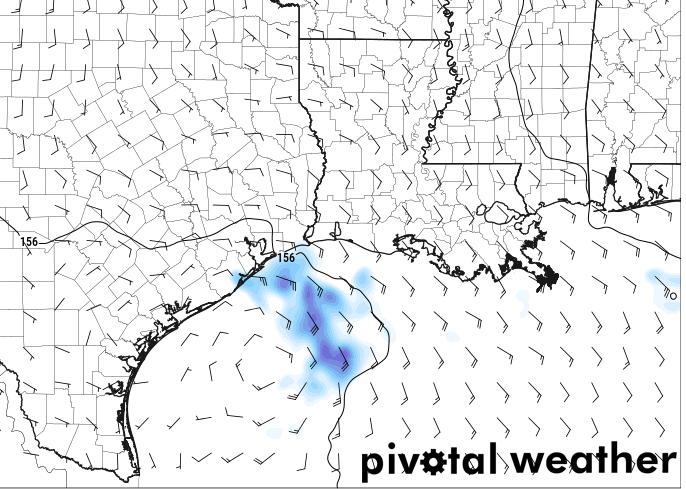
This little area of lower pressure will spin around near Houston today, tomorrow and into the weekend. There is some low-end risk that it tried to sneakily develop into a tropical depression, but I don’t think it’ll have enough time – nor the proper conditions – to really get all to ramped up into anything powerful or terribly organized.
But it will keep our area under this southerly and southeasterly flow – giving us shots for afternoon storms.
As we head toward next week, it looks like a front may try to sneak into the area. I’m still not sold on how far south it will get, but it worth monitoring.
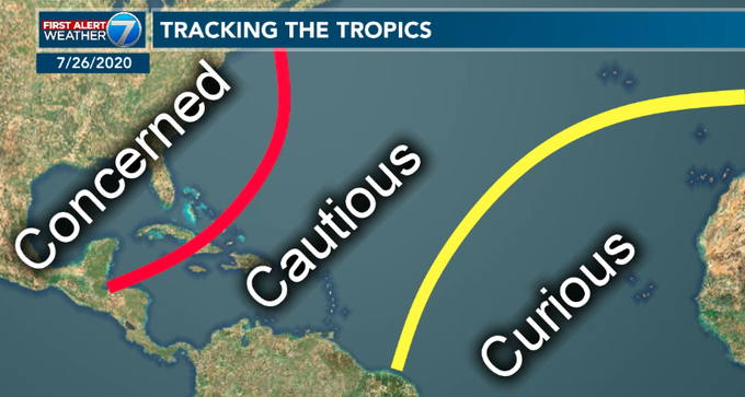
Speaking of monitoring things. The tropical wave I mentioned a few days ago continue to drift westward and is getting into an area where we need to start paying slightly more attention to it.

I posted the map below a handful of years ago (back in 2020) and I think it still holds true today. The wave is in the “Cautious” area. No reason to be worried about it, but it is worth monitoring a bit closer as it continues to drift west.
Model guidance seems mixed on whether or not it will develop – though I tend to think it will likely turn into *something* and probably be named. Beyond that, no one can know. The forecast data has been all over the road and there isn’t enough run-too-run consistency to paint anything more specific than “something probably will happen somewhere.”
Borrowing a line from American Dad….

For those folks seeing that, “two hurricanes in the gulf” post floating around social media. It is from 2020. Here is the same map, from me, four years ago, on Twitter. Today, that map is a hoax.
For now, keep an eye on the one thing to watch in the Atlantic and the area of rain near Texas.
REGIONAL DAY TO DAY FORECAST
Today: Partly sunny. A chance of showers and thunderstorms this morning, then showers and thunderstorms likely this afternoon. Highs in the mid 90s. Southeast winds 5 to 10 mph. Chance of rain 40 percent. Heat index values up to 106.
Tonight: Mostly cloudy with a chance of showers and thunderstorms. Humid with lows in the mid 70s. Southeast winds around 5 mph. Chance of rain 20 percent.
Friday: Showers likely. A chance of thunderstorms in the morning, then thunderstorms likely in the afternoon. Humid with highs around 90. East winds 5 to 10 mph, becoming southeast in the afternoon. Chance of rain 40 percent.
Friday Night: Mostly cloudy. A chance of showers and thunderstorms, mainly in the evening. Lows in the lower 70s. East winds around 5 mph. Chance of rain 20 percent.
Saturday: Partly sunny. A chance of showers and thunderstorms in the morning, then showers and thunderstorms likely in the afternoon. Humid with highs around 90. East winds 5 to 10 mph, becoming southeast in the afternoon. Chance of rain 60 percent.
Saturday Night: Mostly cloudy with a slight chance of showers and thunderstorms in the evening, then partly cloudy after midnight. Lows in the lower 70s. Chance of rain 20 percent.
Sunday: Mostly sunny. A slight chance of showers and thunderstorms in the morning, then a chance of showers and thunderstorms in the afternoon. Highs in the lower 90s. Chance of rain 30 percent.
Sunday Night: Partly cloudy. A slight chance of showers and thunderstorms in the evening. Lows in the lower 70s. Chance of rain 20 percent.
Labor Day: Mostly sunny. A slight chance of showers and thunderstorms in the morning, then a chance of showers and thunderstorms in the afternoon. Highs in the lower 90s. Chance of rain 30 percent.
Monday Night: Partly cloudy. A chance of showers and thunderstorms, mainly in the evening. Lows in the lower 70s. Chance of rain 20 percent.
Tuesday: Mostly sunny. A chance of showers and thunderstorms in the morning, then showers and thunderstorms likely in the afternoon. Highs in the lower 90s. Chance of rain 40 percent. Heat index values up to 105.
Tuesday Night: Mostly cloudy with a chance of showers and thunderstorms. Lows in the lower 70s. Chance of rain 30 percent.
Wednesday: Partly sunny. A chance of showers and thunderstorms in the morning, then showers and thunderstorms likely in the afternoon. Highs in the upper 80s. Chance of rain 30 percent.
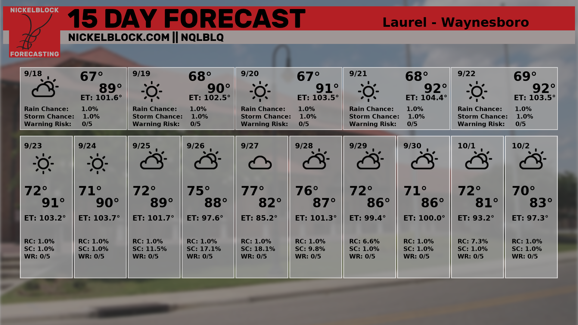
15 DAY OUTLOOK


I know its way too early but I am sure the fronts are gonna have an effect on the not formed tropical system in the carribean