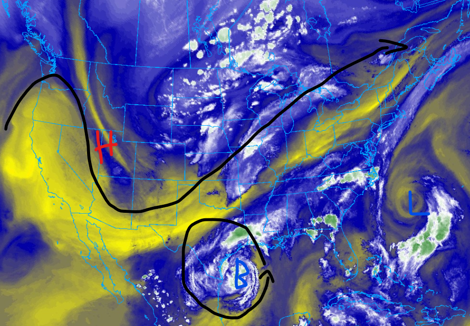
It has been quite active in terms of weather so far this July, and that trend is expected to continue today. Tropical Storm Beryl is expected to restrengthen into a hurricane before making landfall on the Texas Coast. The storm is expected to produce high winds, torrential rainfall, and severe storm surge. After Beryl makes landfall, it is expected to transition to a post-tropical system as it makes its way northeast. Although Beryl is expected to weaken quickly, heavy rainfall and a couple of severe storms are possible in the southern plains. The heavy rain from Beryl is forecasted to cause flooding in areas of the southern plains and upper midwest. It’s quite a different story out west, as a huge ridge of high pressure has been baking the desert west. Record heat is expected to continue for this region through next week; let’s get into this forecast!
Beryl expected to make landfall

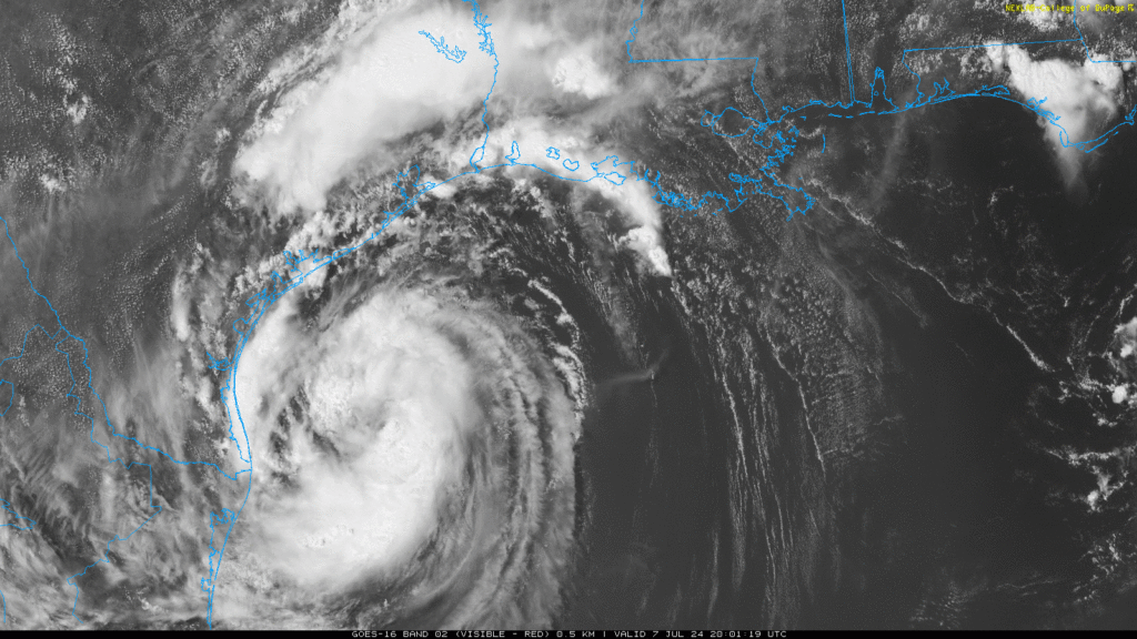
Even though it’s only Early July, we are expecting our first hurricane landfall of the season. This forecast will not cover Beryl in detail, so if you want more information, please read my tropical weather post from today. As of the 1 PM CDT observations, the center of Beryl is located at Lattitude 26.3 North, Longitude 95.3 West, and is moving northwest at 12 mph. The minimum central pressure last observed was 992mb, and the maximum sustained winds were 65 mph. The system is expected to strengthen back into a hurricane as it continues to move northwest. Hurricane warnings have been issued for areas of the Texas Coast, including Corpus Christi, Rockport, Victoria, and Bay City. Tropical Storm warnings have been issued for other areas of the Coast, including the Houston Metro Area. As shown in the image above, the first outer bands of the storm are already starting to impact the Texas Coast. As the outer bands of Beryl move ashore, a couple of imbedded severe thunderstorms are possible, with tornadoes being the primary threat. Please take this afternoon to prepare for Beryl’s arrival and/or evacuate, as landfall is expected overnight.
Other impacts expected from Beryl
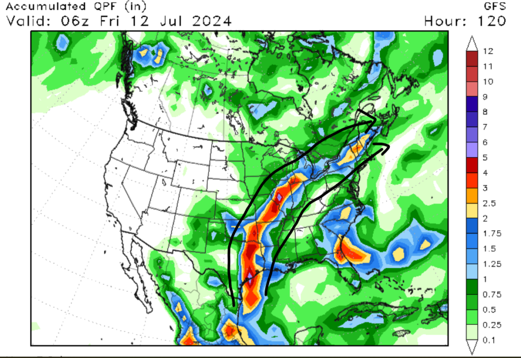
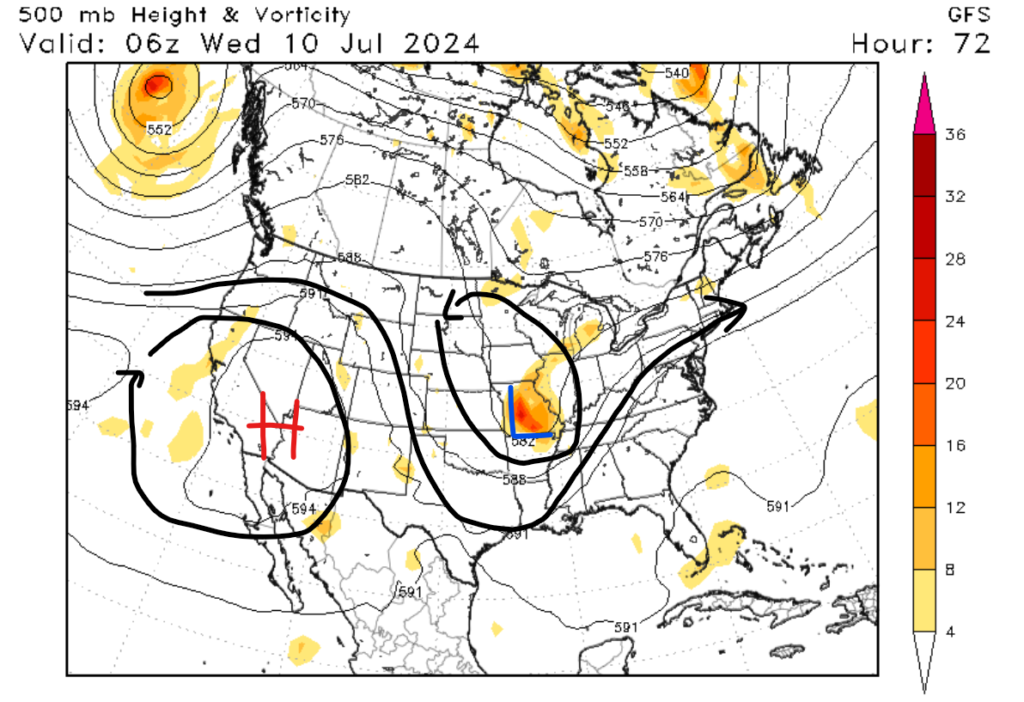
Although the news may be discussing Beryl’s expected impacts along the Texas Coast, it’s not like the storm is going to die after making landfall. It is forecasted to be quite the opposite, with heavy rainfall and high winds expected well inland. Beryl is expected to transition to a post-tropical system as it moves into Northeastern Texas. The system is forecasted to move in a northeasterly direction before moving off into the Atlantic Ocean off the coast of Massachusetts. If you look at the 500mb height map above, you can see a prominent ridge of high pressure (I’ll get to that later) in the western U.S. The way this high-pressure system is positioned is causing Beryl to move north/northeast, allowing it to take aim at major cities in the southern plains and upper midwest. The cities that will see the greatest impact are Dallas, Tulas, St. Louis, and Chicago. Heavy rain of up to 6 inches is expected over the next several days, with high winds and a few severe storms expected as the remains of Beryl moves through the Nation. This heavy rain could result in flash flooding in low-lying and poorly draining areas, so please take the necessary flooding precautions.
The West is cooking
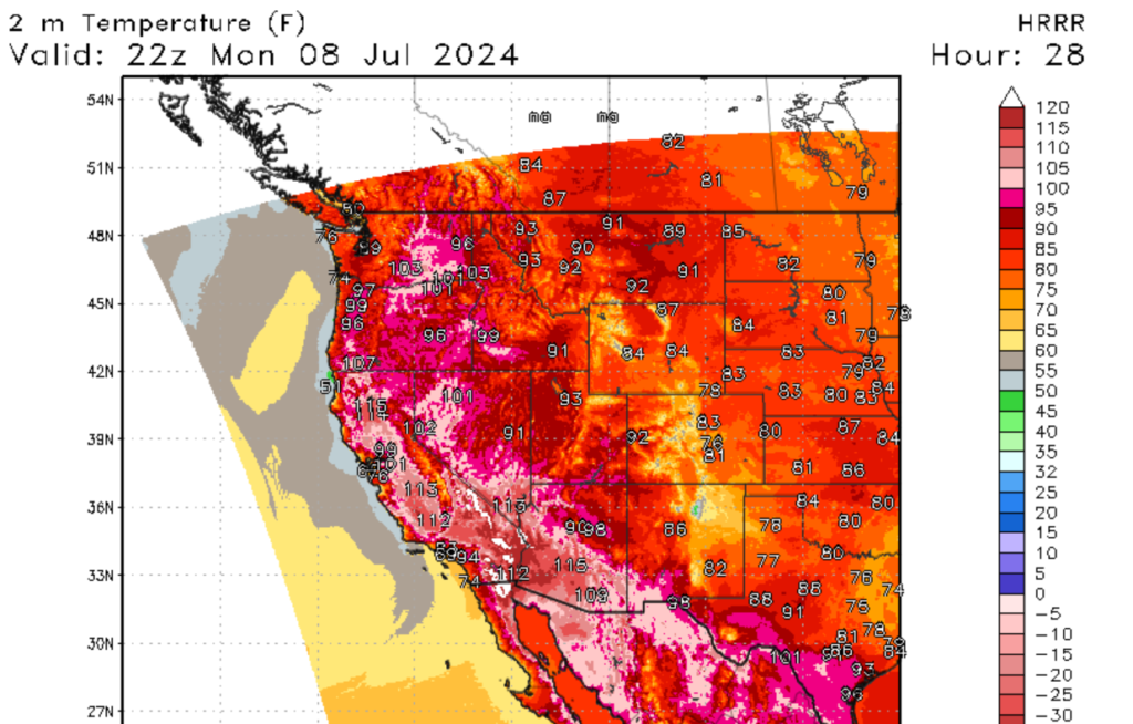
Changing gears here, we have quite a different story out west, where recorded heat has been in place for the last couple of days. These abnormally high temperatures have been caused by a prominent ridge of high pressure that has set itself up in this region. As of this writing, the ridge of high pressure is expected to stick around for the next few days. Record highs have been broken across the west over the last couple of days, with Death Valley, California, recording a high temperature of 127 degrees Fehernight on July 6th. Temperatures are expected to be 15-30 above average, with overnight lows providing little relief, especially in major cities. Please make sure to take the necessary heat-related precautions for the next few days.
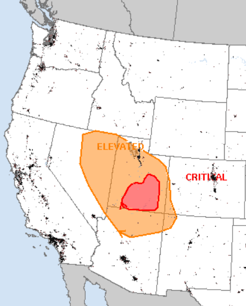
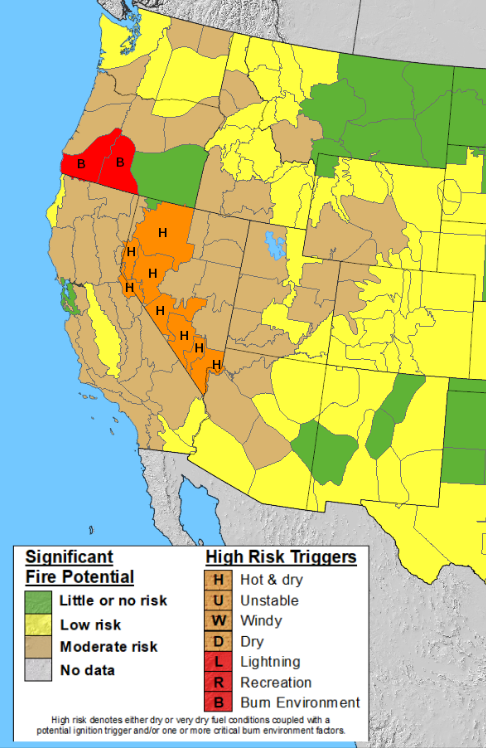
Due to the dry weather affecting the Western United States, wildfire potential is forecasted to be elevated to high over the next couple of days. Moderate winds, high temperatures, low humidity, and dried-out plant life are expected to elevate the fire risk. Areas under the greatest wildfire threat are portions of western Nevada and southern Oregon. Please ensure that you take proper fire-related precautions if you are planning on burning, and ensure you have a source of extinguishment with you. As Smokey the Bear states, “Only you can prevent wildfires.”
A look into the future


Looking into the future, one thing seems obvious to me: the heat looks to spread to the east. I am forecasting that the heat in the west will weaken slightly, but I am expecting that the heat will spread to the east. In simple terms, I predict that most of the Continental U.S. will see above-average temperatures starting this Friday and continuing through the week of the 15th. As we approach the middle of summer, I would not be surprised if we see a lot of recorded highs broken in the next couple of weeks.


