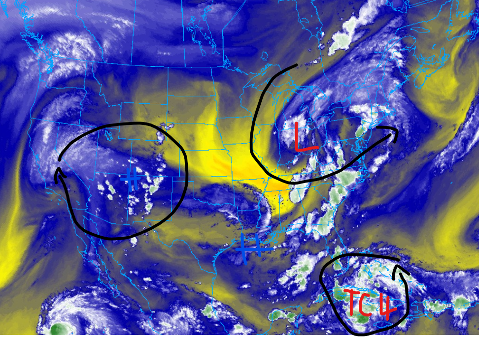
As August approaches, we are starting to see quite a lot of action in our weather nationwide, from heat waves to tropical storms and heavy rainfall. We will get into all of that in this report, starting off with the heat wave that is baking both the West and Gulf coasts of the U.S. This is thanks to multiple areas of high-pressure systems. Looking further south, a potential tropical storm may cause impacts to Florida and the coast of the Southeastern U.S. Heavey rainfall, gusty winds, and coastal flooding are the primary threats with this storm. Back in the Continental U.S., heavy rainfall from a mid-level trough is expected to soak the Northeastern U.S. We have a lot to discuss in this report, so let’s get into it!
More heat expected
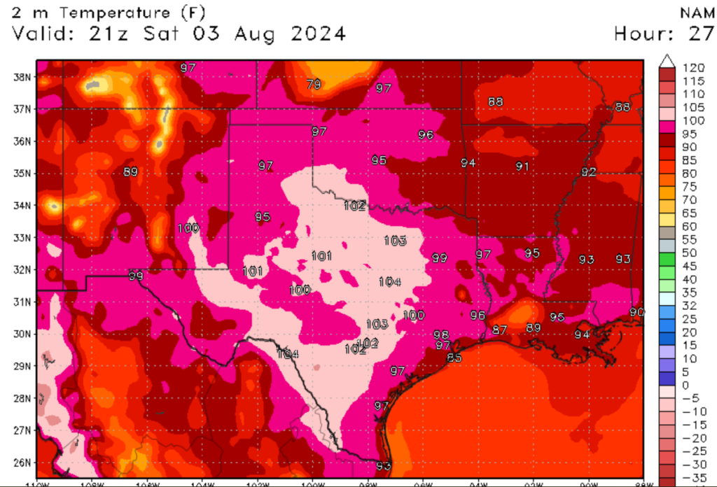
It has been quite a hot summer so far, and I expect that this trend will continue for the next couple of days for parts of the Gulf and West Coast. For the Gulf Coast (which includes areas inland), temperatures are expected to be anywhere from the low 90s along the coast to the low 100s for areas of Texas. Combined with high humidity levels, heat index values will be oppressive, causing concern for heat illnesses. A few storms could pop up tomorrow for the Gulf region thanks to a frontal boundary, but these will be isolated in nature and provide no relief from the heat,
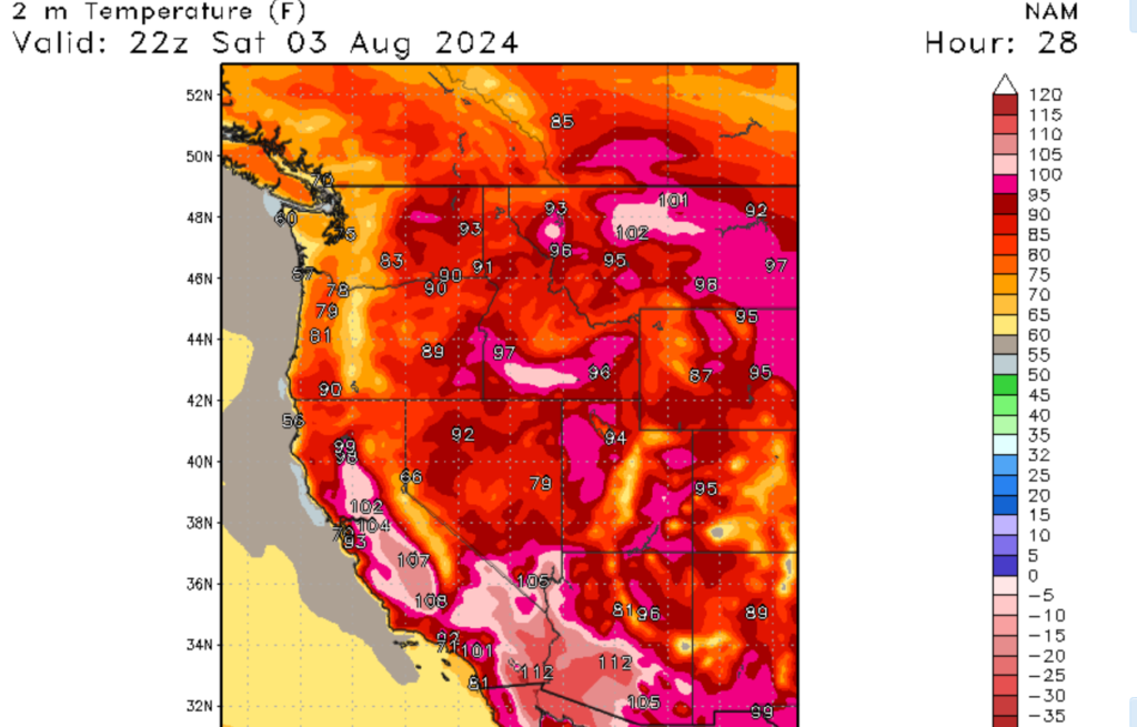
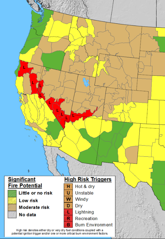
Looking out west, a large high-pressure system is dominating the West Coast, Intermountain West, and the Great Plains. Temperatures from the Intror Northwest to the northern Rockies and Western Great Plains are forecasted to see temperatures of over 100 degrees Fehernight. The only areas that will escape the extreme heat are the coastal areas of the West Coast and the high Mountains of Colorado, Wyoming, and Montana. Unlike the Gulf Coast, heat index values will be about the same as the air temperatures due to the low relative humidity values. Unfortunately, the low relative humidity values will promote an increase in the wildfire threat.

A possible tropical storm

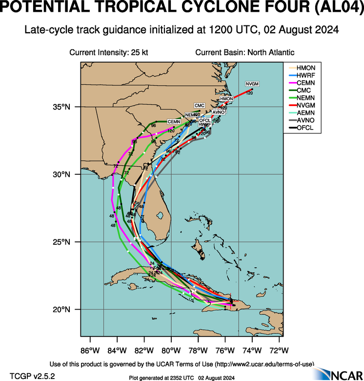
Now that we are in the month of August, hurricane season is now in full swing. As you can see in the images above, we have a possible tropical system that could develop into a tropical storm by the end of this weekend. This storm would be named Tropical Storm Debby and could have an impact on the state of Florida, as well as the coastal Southeast.

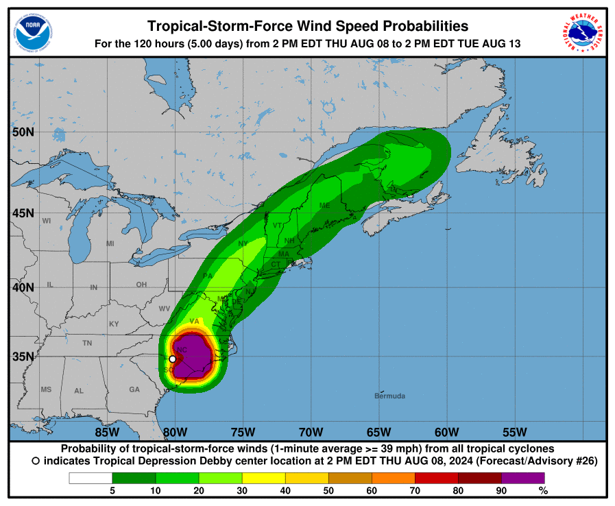
As of this writing, the primary threats that one can expect from this storm are heavy rainfall and coastal flooding from storm surges. Parts of Florida could see over 3 inches of rain in the next few days, with localized amounts of over 6 inches possible. The Florida Gulf Coast will be in the bullseye for storm surge and coastal flooding from Saturday Evening to Monday Morning. Gusty winds could cause some minor tree and structural damage throughout Florida. Even though this system is only expected to make landfall as a tropical storm, it can still cause major impacts on life and property. If you are in the path of this storm, please take the necessary hurricane precautions.
Rain for the Northeast and severe weather for the north
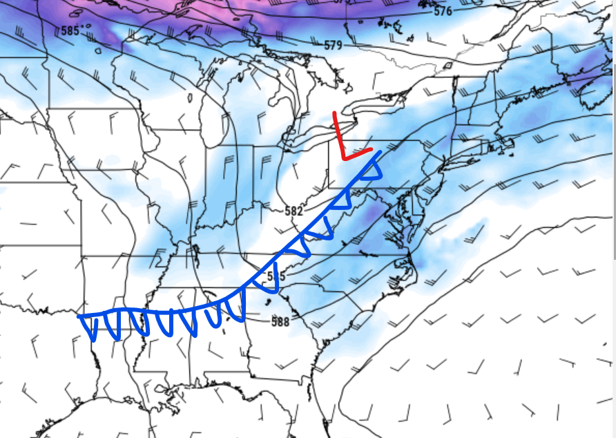
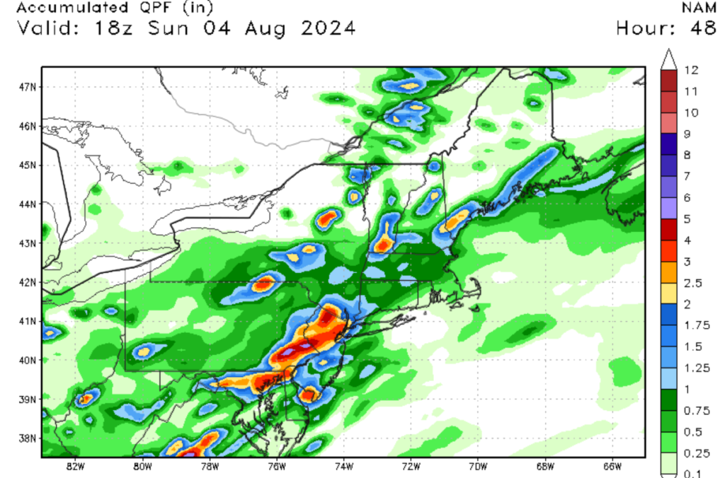
In contrast to the heat out west and the south, an upper-level disturbance and cold front are expected to soak the Northeastern U.S. over the weekend. This anticyclonic system is separate from the potential tropical storm in the Atlantic. Flooding is possible for parts of the Appellations and Mid-Atlantic, as this system is expected to stall out over the region. Although the front will provide some relief from the heat, flooding in the Appellation Mountains is a concern this weekend.
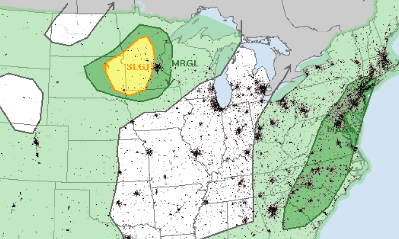
On the backside of this trough, severe weather is possible in the Northern Plains as a northwesterly flow associated with another cold front moving in from Canada. Due to the moderate instability and the northwesterly flow, hail and high winds will be the primary threats to the region. A MCS system would be the primary canadit for high winds tomorrow for the region, as the front makes its way across the Northern Plains. Please remember to stay weather-ready tomorrow if your region was mentioned in this discussion.
A look into the future


Looking into the future, it looks like the central part of the United States will see above-average temperatures, as well as parts of the Southeast and West Coast. This is not good news because this part of the country has delt with quite a hot summer, so this does not help. Those in the affected areas should take heat-related precautions and monitor the latest heat warnings and advisories for their area.


