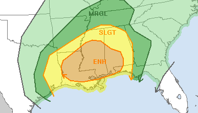
Looking toward Monday, the threat for severe weather returns to Louisiana, Mississippi, and Alabama. The Storm Prediction Center has issued an Enhanced Risk for severe weather – suggesting a 3 out of 5 on their five-tier severe weather scale.
Generally, the timing puts storms in here starting as early as 11am, sticking around through 8pm. But that is likely going to change given the current set up.

Here is the latest discussion from the SPC:
A warm front (portions of which will be convectively reinforced)
will likely extend from a weak surface low in northeast TX ewd
through southern portions of the Gulf coast states. In response to
ejecting southern-stream shortwave trough the surface low will
develop northeastward, reaching northern MS by Monday evening, while
the warm front will make only slow northward progress. A cold front
extending south from the low will move through eastern TX and the
lower MS Valley region during the day and into the southeast states
overnight.Primary complicating factor/uncertainty with regard to this outlook
is the evolution of the thermodynamic environment and potential for
ongoing convection. Greatest instability will reside from eastern TX
into a portion of the lower MS valley where plume of steeper lapse
rates will have overspread moist axis south of warm front where
mlcape to 1500 j/kg is possible. Widespread clouds and weaker lapse
rates will limit mlcape to aob 1000 j/kg farther east, with the
greater instability expected south of warm front over southern
portions of Gulf coastal states. A few severe storms are expected to
be ongoing along cold front across eastern TX where vertical shear
and instability will support organized structures including a few
supercells and bowing segments. This activity will persist into the
lower MS Valley. Another corridor of severe storms is expected as
storms develop over the gulf coast states, especially along warm
front and warm sector confluence bands as the low-level jet
strengthens. Low-level hodographs and strong effective bulk shear
will support potential for a few supercells with isolated tornadoes
possible. Severe threat becomes increasingly uncertain with
northward extent into Alabama and Tennessee due to limited potential
for boundary layer destabilization north of warm front.
The K-Meter (the south Mississippi severe weather index I’ve created) is running between a 6 and a 7, which lines up with the SPC’s thinking. Depending on which model you look at we could be in for a lot of rain and straight-line wind across the south OR in for a day th a handful of supercells and a few tornadoes – some possibly on the stronger side, too.
I’m not sold that we get sunny enough and warm enough on Monday to get the storms surface-based. If that holds, the tornado threat would be a bit lower. But, sadly, the modeling for events like this is always pretty poor. So we often – as a meteorological community – err on the side of caution.
So make plans now. Know what you would do if a Severe Thunderstorm Warning or Tornado Warning was issued for your area. Put those essential items in your safe place now, so you aren’t looking for medications or important items while you are trying to get to safety. If you live in a mobile home, reach out to a friend with a foundation-based building or storm cellar. Ask them if you can come over if the weather gets bad.
Of course, we will update you with the latest information when we get it.

