We had a little front/boundary move through last night. That will help to limit temperatures today to just the upper 80s to around 90 degrees. Much better that yesterday, which went down as the fourth-warmest September 22 on record! We tagged 96F!
After that, I think 88-90 sounds much better.

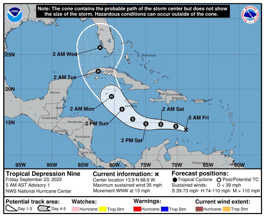
Of course, all eyes are on the tropics. And this morning, the National Hurricane Center minted Invest 98L as Tropical Depression Nine.

That also means they issued their first Forecast Cone.

This looks to be in line with a lot of the model guidance that came out overnight. It really helps that this thing developed a center yesterday and we saw a blow-up of convection overnight. It allows the models to do a better job and allows the meteorologists to use those models to create more meaningful forecasts.
DAY TO DAY FORECAST
Today
Sunny. Highs in the upper 80s.
Tonight
Clear. Lows in the mid 60s.
Saturday
Sunny. Highs in the lower 90s.
Saturday Night
Mostly clear. Lows in the upper 60s.
Sunday
Sunny with a few passing storms possible. Highs in the lower 90s. Chance of rain 20 percent.
Sunday Night
Mostly clear with a slight chance of showers and thunderstorms. Lows in the upper 60s. Chance of rain 20 percent.
Monday
Sunny. Highs around 90.
Monday Night
Mostly clear. Lows in the lower 60s.
Tuesday
Sunny. Highs in the mid 80s.
Tuesday Night
Clear. Lows in the upper 50s.
Wednesday
Sunny. Highs in the lower 80s.
Wednesday Night
Clear. Lows in the upper 50s.
Thursday
Sunny. Highs in the lower 80s.

