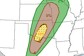
8:00AM UPDATE: It looks like the Storm Prediction Center has dropped the significant tornado risk for today. But keep in mind there is still a 5% tornado risk.

It looks like the atmospheric conditions are ripe for some severe weather across parts of central Oklahoma this afternoon.
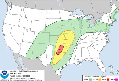
The Storm Prediction Center has issued a “Moderate” risk and a 10% tornado chance with a hatched area of EF-2 to EF-5 tornadoes possible.
It looks like the greatest risk is between Vernon, Texas and Bartlesville, Oklahoma.
By this afternoon instability levels – or CAPE Values – will be between 1500 J/kg and 3500 J/kg and the effective shear will be well above 45 knots – meaning the atmosphere is capable of producing and sustaining supercell thunderstorms.
Helicity levels are projected to be between 200 m2/s-2 and 500 m2/s-2 which means rotating updrafts are possible and with a reading over 400 m2/s-2, tornadoes are also possible.
If you live in one of these area please have a severe weather plan. Take shelter if a Severe Thunderstorm Warning or Tornado Warning is issued for your area.


