We’ve got a bit of fog this morning. But aside from that, things should be decent as you get out the door.
It’ll be another day that is mostly dry with a few folks that see some rain. That shot for showers and storms will be this afternoon and evening, but storms should be well below severe limits and will offer a shot for a brief heavy rain, lightning and some gusty wind.

Then we play the same song and dance tomorrow, too.
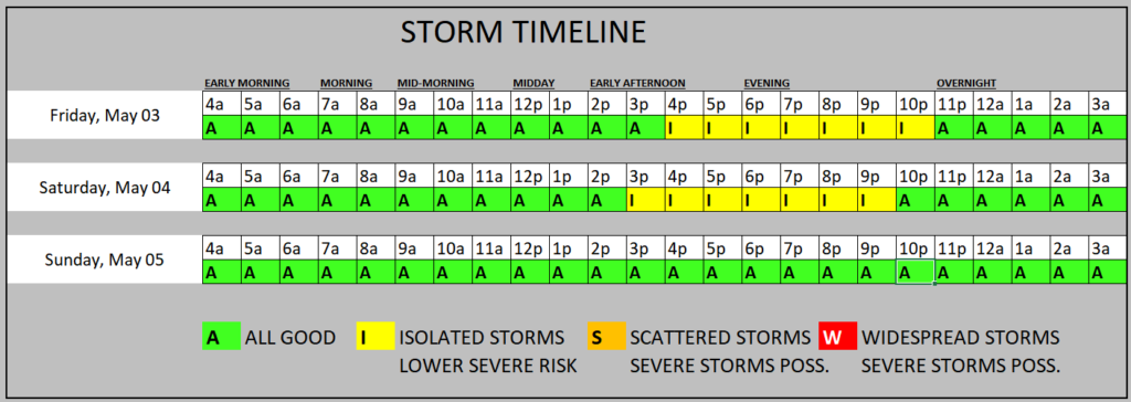
Sunday, things should calm down but then next week we may again see passing storms possible as MCSs try to sneak toward the Gulf.
REGIONAL DAY TO DAY FORECAST
Today: Areas of dense fog this morning. Partly sunny with a 20 percent shot for rain. Highs in the mid 80s. Southeast winds around 5 mph, becoming south this afternoon.
Tonight: Mostly cloudy. Lows in the upper 60s. South winds 5 to 10 mph.
Friday: Partly sunny. A slight chance of showers and thunderstorms in the afternoon. Highs in the mid 80s. South winds 5 to 10 mph. Chance of rain 20 percent.
Friday Night: Partly cloudy. Lows in the mid 60s. Southeast winds around 5 mph.
Saturday: Mostly sunny. A slight chance of showers and thunderstorms in the afternoon. Highs in the upper 80s. Southeast winds 5 to 10 mph. Chance of rain 20 percent.
Saturday Night: Partly cloudy. Lows in the mid 60s.
Sunday: Mostly sunny. Highs in the upper 80s.
Sunday Night: Partly cloudy. Lows in the upper 60s.
Monday: Mostly sunny. Highs in the upper 80s.
Monday Night: Mostly clear in the evening, then becoming partly cloudy. Lows in the upper 60s.
Tuesday: Mostly sunny. Highs in the upper 80s.
Tuesday Night: Mostly clear in the evening, then becoming partly cloudy. Lows in the upper 60s.
Wednesday: Mostly sunny. Highs around 90.


