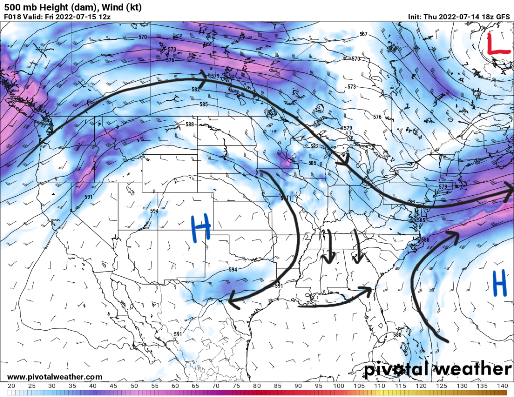
The Southeast will continue to see showers and storms into the weekend as the stationary front meanders over the northern half of Mississippi, Alabama, and Georgia. The overarching pattern is a weakness in the atmosphere over the region. Now, what does that mean?
There is the upper-level high pressure ridge over the Southwest to the region’s west and the Bermuda high extending into the Florida Peninsula over the Atlantic to the east. With a trough dipping down some from the north, there is weak flow aloft over the region. This allows the frontal boundary to initiate slow moving showers and storms over the area causing the flooding threat. The excessive rainfall threat continues into Friday with places near the Gulf Coast seeing the most rainfall.
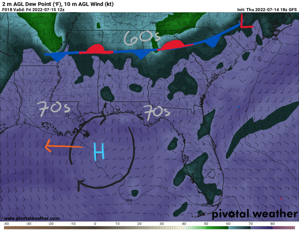
Near the surface, there is a surface high pressure over the Northern Gulf. Throughout the day, it will move towards the west. This will cause winds over the Florida Panhandle to shift from northerly to westerly into the late afternoon. Winds will be southerly from coastal Alabama westward.
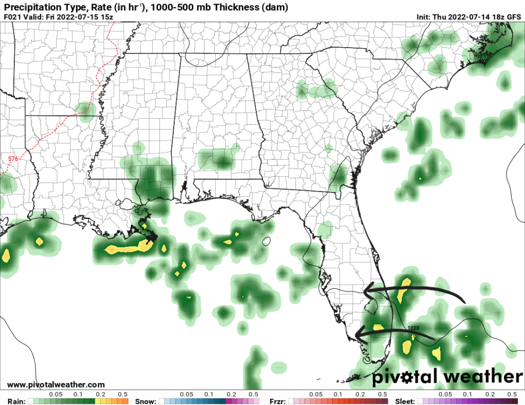
The sea-breeze will then kick off to initiate scattered storm activity where dewpoints are in the mid 70s near the Gulf Coast and Florida Peninsula. Precipitable water values range between 1.6″ to 2.1″ over the area to support heavy rainfall. Storms will move into the Gulf Coast into the early morning hours with the help of some outflow boundaries over the Gulf.
More inland, rainfall will decrease in coverage on the northern side of the boundary. Dewpoints will be in the 60s with precipitable water values decreasing below 1.5″.
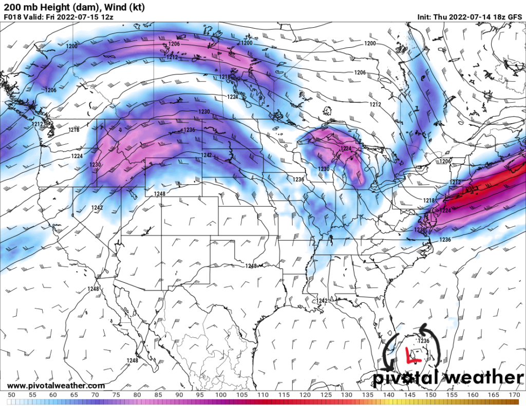
Southeast of southern Florida is a feature known as a Tropical Upper Tropospheric Trough, or TUTT. Basically, a TUTT is an upper-level low pressure that exists at around 200mb (around 40,000ft). There is no surface low associated with this; therefore, there is no tropical threat. However, these can be associated with some unsettled weather. An increased coverage of storms can be expected for southern Florida as this feature dissipates northeastward. These storms will follow the rest of Florida’s sea-breeze storms and move towards the west.
Temperatures Friday will be in the upper 80s to low 90s in most places. Rainfall and cloud cover will help cool down those area that receive it. More towards the west over northern MS and LA, AR, and TX, rain coverage will be sparse and high temperatures will reach into the upper 90s.
Saturday
The stationary front continues to stay over the South through the Mid-Atlantic states providing showers and storms for much of the region. The upper-level ridge over the Rockies will stretch towards the east on Saturday bringing more northerly flow. As a result, drier conditions will follow behind the surface frontal boundary.
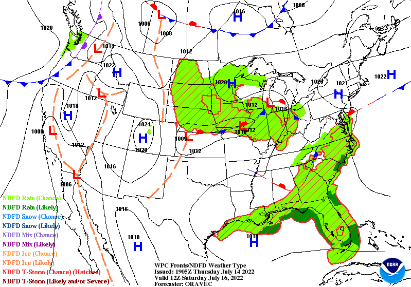
Dewpoints in more inland areas will be in the mid 60s. Thunderstorm activity will have to rely on daytime heating. Near the coasts, dewpoints will be high in the 70s. Showers and storms will be more concentrated near the coasts and over the whole Florida state as their sea-breeze convection will be prevalent as the Bermuda high will still exhibit easterly flow aloft to steer the storms towards the west.
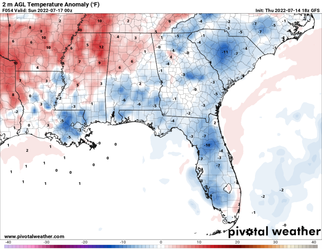
Since the upper-level ridge will reach to the east and the upper-level trough over the Northeast will start to back away, temperatures towards the western half of the region will see an increase. Highs over this area could reach the upper 90s and possibly hit 100F is some places. Heat indices will be more prevalent, especially in places with higher humidity. Values could reach past 100F and even get to 105F. Now, not every state will see this increase in temperature. The southeast side of the region will have increased rain coverage and cloud cover that will help keep temperatures down in the mid-to-upper 80s and low 90s. The image below depicts the temperature departure from normal showing a cooler side where showers and storms will be and a warmer western side.
Sunday
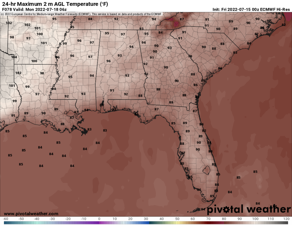
Sunday will be very similar to Saturday with scattered showers and storms throughout the region. Weak flow aloft between the two upper-level ridges will support slow moving storms capable of heavy rainfall as precipitable water values increase above 1.7″ across the Southeast. As the ridge over the Rockies stretches eastward a bit more, high temperatures will increase to the upper 90s and low 100s and reach more to the east into Mississippi and Alabama. The rest of the region will see highs in the upper 80s and low 90s with any rainfall helping to cool the atmosphere.
3-Day Forecast
| Dallas | ||
| Friday | Saturday | Sunday |
| High: 99 | High: 101 | High: 103 |
| Low: 80 | Low: 81 | Low: 81 |
| Precip: None | Precip: None | Precip: None |
| Houston | ||
| Friday | Saturday | Sunday |
| High: 90 | High: 96 | High:96 |
| Low: 77 | Low: 77 | Low: 78 |
| Precip: 40-percent | Precip: 30-percent | Precip: 20-percent |
| New Orleans | ||
| Friday | Saturday | Sunday |
| High: 88 | High: 88 | High: 88 |
| Low: 76 | Low: 78 | Low: 78 |
| Precip: 80-percent | Precip: 60-percent | Precip: 60-percent |
| Little Rock | ||
| Friday | Saturday | Sunday |
| High: 96 | High: 98 | High: 99 |
| Low: 74 | Low: 76 | Low: 76 |
| Precip: None | Precip: None | Precip: 20-percent |
| Memphis | ||
| Friday | Saturday | Sunday |
| High: 100 | High: 100 | High: 98 |
| Low: 75 | Low: 76 | Low: 76 |
| Precip: None | Precip: None | Precip: 30-percent |
| Birmingham | ||
| Friday | Saturday | Sunday |
| High: 93 | High: 94 | High: 94 |
| Low: 72 | Low: 72 | Low: 74 |
| Precip: 20-percent | Precip: 20-percent | Precip: 20-percent |
| Atlanta | ||
| Friday | Saturday | Sunday |
| High: 90 | High: 88 | High: 90 |
| Low: 71 | Low: 70 | Low: 70 |
| Precip: 30-percent | Precip: 30-percent | Precip: 30-percent |

