We’ve had a fairly warm day today with highs reaching the low 80s and some low level cumulus clouds. It might seem like a late Spring day, but I assure you, we’re only in March so far. The next few days will feel like a bit of whiplash as we dive into a more wintry like morning on Friday and jump towards the upper 70s by Saturday.
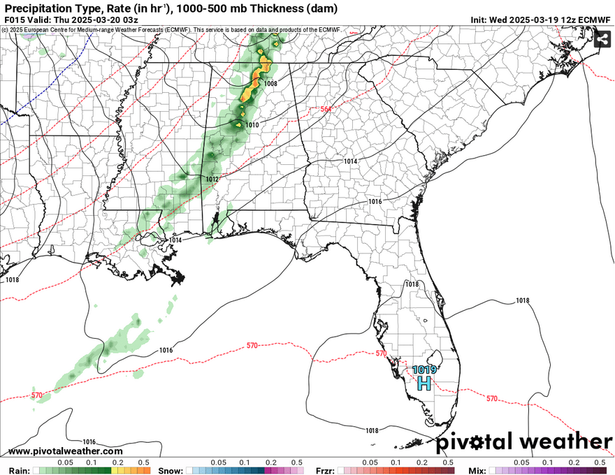
Tonight we’ll see some scattered showers roll in from a front in the upper Midwest. These don’t really pose a threat at all, but as they cross the Alabama border, the rain may get a little heavier. For the Pinebelt, it’ll be some scattered rain showers and possibly a thunderstorm after sunset. Afterwards, the northwest winds will roll in bringing some cool, dry air with some 30mph wind gusts and lows in the mid 40s. We’ll have a lack of clouds in the sky Thursday with winds gusting out of the northwest again and a high in the low 60s.
Due to the cold airmass above, temperatures will dive into the low to mid 30s overnight into Friday meaning frost is possible across much of the Pinebelt and northward. We’ll see a high around 70 with winds shifting towards the south due to the surface high’s shift towards the Atlantic. The low will reach the mid 40s with the upper level clouds beginning to roll in.
Saturday will be another warm day as the south winds prevail, however it’ll be a nice day overall. Highs will be in the upper 70s during the day with a slight west wind. Overnight, it’ll be fairly mild with a low in the low 50s.
The SPC has shifted the risk for severe weather further south from Arkansas to parts of central Louisiana and Mississippi. The NWS in Jackson has placed a Slight (2/5) risk for areas along and west of I-55 and a Marginal (1/5) risk for areas around I-59. So far, the risk is pretty low for our area for a few reasons. The first is a lack of moisture inflow. The GFS is more aggressive, but even then the moisture is centered towards much of northern Louisiana and west central Mississippi. As the cold front moves in towards the midnight hours, it begins to weaken the inflow.
The main risks for this system look to be high winds and hail. Wind gusts up to 60mph are possible and hail cores may develop along with some of the storms. I won’t doubt we’ll see a few strong to severe storms in our area, but not like what we saw last week. The rain will remain into Monday morning and then we will cool off a bit.
The next few days to start of the week will be much quieter and nicer. We’ll start off cool on Monday morning with temperatures in the mid 40s and highs in the low 70s. Tuesday will be sunny with a high in the upper 70s and a low around 50. By Wednesday, we’ll warm back up into the upper 70s to around 80 and a low in the 50s.
Select Data Set:

Regional Day-to-Day Forecast
Tonight – A slight chance of showers between 8pm and 11pm. Mostly cloudy during the early evening, then gradual clearing, with a low in the mid 40s. South southwest wind 10 to 15 mph becoming west northwest after midnight. Winds could gust as high as 30 mph. Chance of precipitation is 20%.
Thursday – Sunny, with a high in the low 60s. Northwest wind around 15 mph, with gusts as high as 30 mph.
Thursday Night – Clear, with a low in the low to mid 30s. Northwest wind 5 to 10 mph becoming light in the evening. Winds could gust as high as 20 mph.
Friday – Areas of frost before 8am. Otherwise, sunny, with a high near 70. Calm wind becoming south southwest around 5 mph in the afternoon.
Friday Night – Clear, with a low in the low to mid 40s. South southwest wind around 5 mph becoming calm in the evening.
Saturday – Sunny, with a high in the upper 70s. Calm wind becoming west around 5 mph in the afternoon.
Saturday Night – Mostly clear, with a low in the low 50s. South southeast wind around 5 mph becoming calm.
Sunday – A 20 percent chance of showers and thunderstorms after 1pm. Partly sunny, with a high in the upper 70s. South wind 5 to 10 mph increasing to 10 to 15 mph in the afternoon. Winds could gust as high as 25 mph.
Sunday Night – Showers and possibly a thunderstorm. Low in the mid 50s. South wind 5 to 10 mph becoming west southwest after midnight. Winds could gust as high as 20 mph. Chance of precipitation is 80%.
Monday – A 20 percent chance of showers and thunderstorms before 1pm. Partly sunny, with a high in the low 70s.
Monday Night – Mostly clear, with a low in the mid 40s.
Tuesday – Sunny, with a high in the upper 70s.
Tuesday Night – Mostly clear, with a low in the low 50s.
Wednesday – Mostly sunny, with a high near 80.


