The weather pattern is mostly unchanged through the weekend. Still warm, still humid, still a chance for showers and storms.
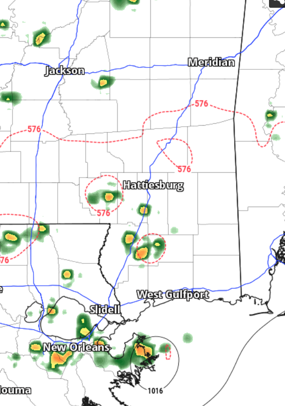
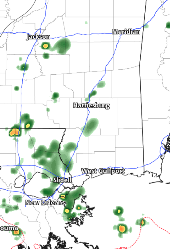
I don’t think the models are handling the extra shots for rain very well. I tend to think the graphics I’ve shown above are too sparsly peppered with showers and storms both this afternoon and overnight.
While severe weather isn’t likely today, storms will still pack a punch at times with brief heavy rain, lightning and gusty wind. The flash flooding risk continues, too. That said, according to the local NWS folks, while the presence of a deep, tropical air mass and significant warm cloud depths raises concerns for localized flooding, particularly in low-lying and urban areas where flash flooding remains possible, recent rains have made soils more responsive, reducing flash flood guidance and enhancing runoff potential.
So it is a bit of a mixed bag. The atmosphere is more conducive to producing flooding rains, but the soil is now better equipped to hold that extra rain.
Looking ahead, the long-term forecast remains consistent, with no significant changes expected through the upcoming weekend. The region will remain between an upper-level trough across the central states and ridging over the southeastern states, resulting in a southwesterly flow that brings tropical moisture. Rain chances will be diurnally driven but continuous, with potential for heavy downpours and several inches of rain in a short period. The threat of limited flash flooding will persist, particularly south of I-20, with the coverage of the flood risk being reassessed daily. As the troughing pattern evolves, rain chances are expected to decrease in intensity but continue through the weekend.
As an aside, I heard from a lot of you guys through the Spring worried about another drought this summer. Other outlets were – I’m told – warning people about a repeat of the 2023 Summer where it was 95+ nearly every day and dry.
In March, I put out this forecast:
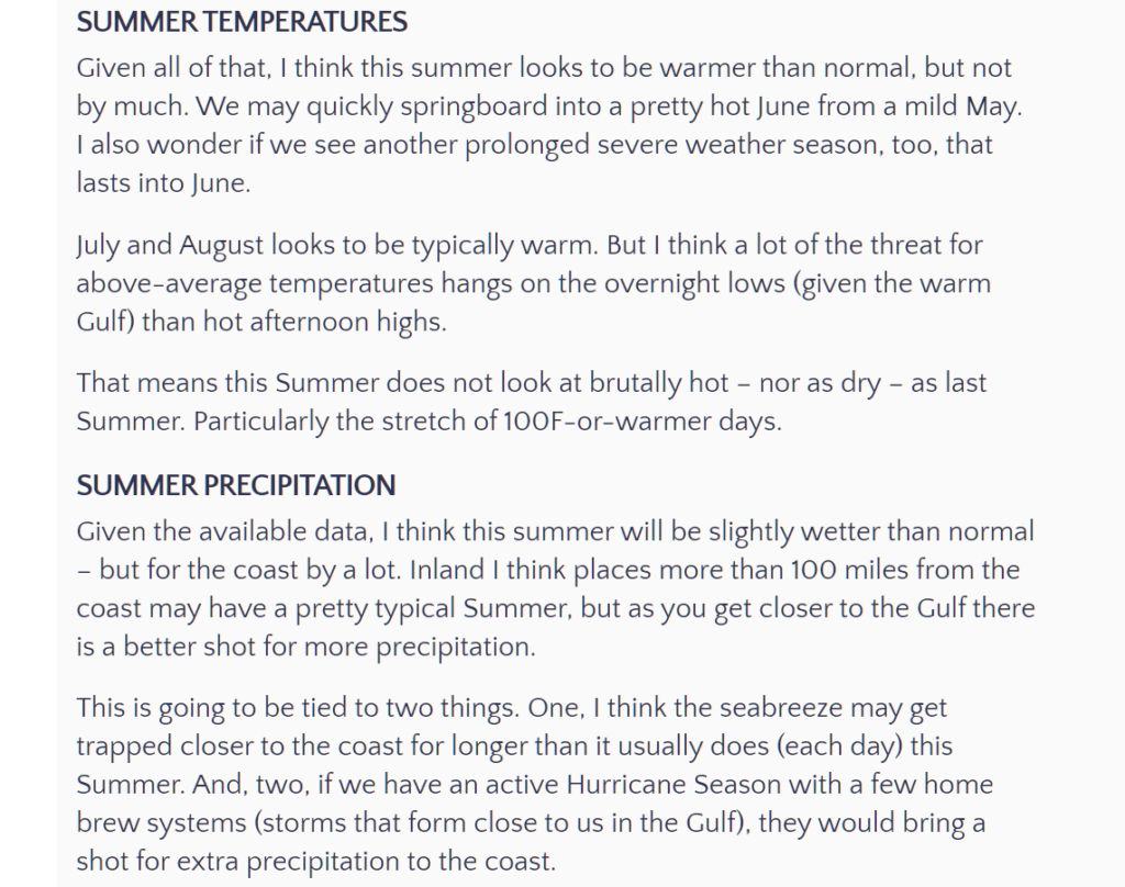
You can find the entire thing here: https://www.nickelblock.com/a-way-too-early-dive-into-the-central-gulf-coast-2024-summer-hurricane-season-outlook/
When I released it, I was met with a lot of doubters and doom-and-gloomers. But so far, one month in, it has held reasonably true.
This isn’t a reminder that “I’m right” but rather that, “fighting the urge to assume the worst is always a good decision.”
Weather can be rough yes. But they won’t always be the roughest. And just because one season was lone way, doesn’t mean the next time around it will be like that – or worse.
REGIONAL DAY TO DAY FORECAST
Today: Partly sunny with a chance of showers and thunderstorms this morning, then mostly cloudy with showers and thunderstorms this afternoon. Highs in the upper 80s. Southwest winds around 5 mph. Chance of rain 90 percent.
Tonight: Mostly cloudy with a chance of showers and thunderstorms in the evening, then partly cloudy with a slight chance of showers and thunderstorms after midnight. Lows in the lower 70s. South winds around 5 mph in the evening, becoming light and variable. Chance of rain 50 percent.
Tuesday: Mostly sunny with a chance of showers and thunderstorms in the morning, then mostly cloudy with showers and thunderstorms in the afternoon. Humid with highs around 90. Temperature falling into the mid 80s in the afternoon. Southwest winds around 5 mph. Chance of rain 80 percent. Heat index values up to 106.
Tuesday Night: Mostly cloudy with a chance of showers and thunderstorms. Lows in the lower 70s. South winds around 5 mph in the evening, becoming light and variable. Chance of rain 50 percent.
Wednesday: Showers and thunderstorms. Humid with highs in the mid 80s. East winds around 5 mph, becoming south around 5 mph in the afternoon. Chance of rain 80 percent.
Wednesday Night: Mostly cloudy with a chance of showers and thunderstorms. Lows in the lower 70s. Chance of rain 50 percent.
Thursday: Partly sunny. A chance of showers and thunderstorms in the morning, then showers and thunderstorms likely in the afternoon. Highs in the upper 80s. Chance of rain 70 percent.
Thursday Night: Mostly cloudy with a chance of showers and thunderstorms in the evening, then partly cloudy after midnight. Lows in the lower 70s. Chance of rain 40 percent.
Friday: Mostly sunny with a chance of showers and thunderstorms. Highs in the upper 80s. Chance of rain 50 percent.
Friday Night: Partly cloudy. A slight chance of showers and thunderstorms in the evening. Lows in the lower 70s. Chance of rain 20 percent.
Saturday: Partly sunny. A slight chance of showers and thunderstorms in the morning, then a chance of showers and thunderstorms in the afternoon. Highs around 90. Chance of rain 50 percent.
Saturday Night: Mostly cloudy in the evening, then becoming partly cloudy. Lows in the lower 70s.
Sunday: Partly sunny. A slight chance of showers and thunderstorms in the morning, then a chance of showers and thunderstorms in the afternoon. Highs in the lower 90s. Chance of rain 50 percent. Heat index values up to 105.


Just looked at the forecast on the NWS site. It doesn’t have a chance of rain below 60% and that’s through Monday of NEXT week! I’m starting to miss last year’s drought where you actually had more than 2 days of NO rain. I wish it ‘was’ cooler.