Hello everyone! I appreciate you taking the time to read my third summer project. As with my other two projects, it is evident that I am a fan of severe and tropical weather. For my topic today, I want to discuss the weather phenomenon known as Derechos and how these storms are just as dangerous as tornados/hurricanes. My research includes facts and information found in various sources that will be linked below. The main points I will focus on today are the formation/characteristics and impacts of derechos while also making a comparison to other common hazards in the United States.
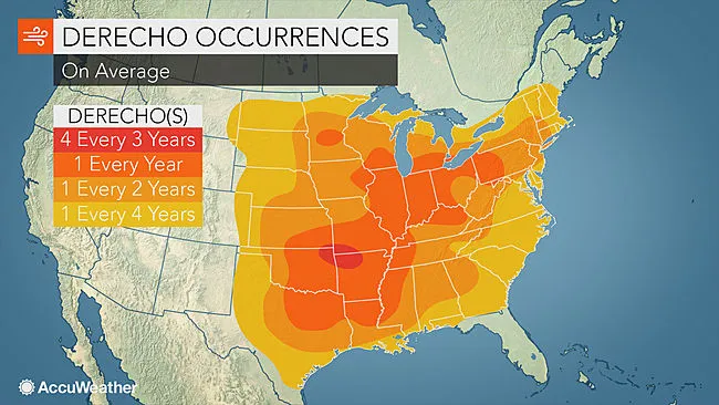
Before jumping into the main points, what is a Derecho? The definition given by the National Weather Service is “a widespread long-lived windstorm associated with a band of rapidly moving showers or thunderstorms,” such as bow echoes or squall lines. Derechos are more common in the Spring/Summer months and mainly affect the Midwest/Great Plains regions of the United States. It is important to note that derechos cover a vast area (240 miles by definition) and last for hours, while tornados are more localized and typically do not last very long. While they have similarities to tornados, derechos also have distinct differences in formation and characteristics.
FORMATION/CHARACTERISTICS:
The formation of a derecho requires a unique set of atmospheric conditions. First, there must be a high level of atmospheric instability, which occurs when warm, moist air near the Earth’s surface resides below cooler, drier air aloft. This instability allows air to rise rapidly, fueling thunderstorm development. Additionally, a significant amount of moisture in the lower atmosphere is necessary to sustain the thunderstorms as they develop and strengthen.

Another critical factor in the formation of a derecho is strong vertical wind shear. Vertical wind shear refers to the change in wind speed and direction with height in the atmosphere. This shear helps tilt the developing thunderstorms, preventing them from collapsing on themselves and allowing them to grow stronger and more organized. When these conditions are met, a line of thunderstorms can develop and merge, creating a powerful mesoscale convective system (MCS).
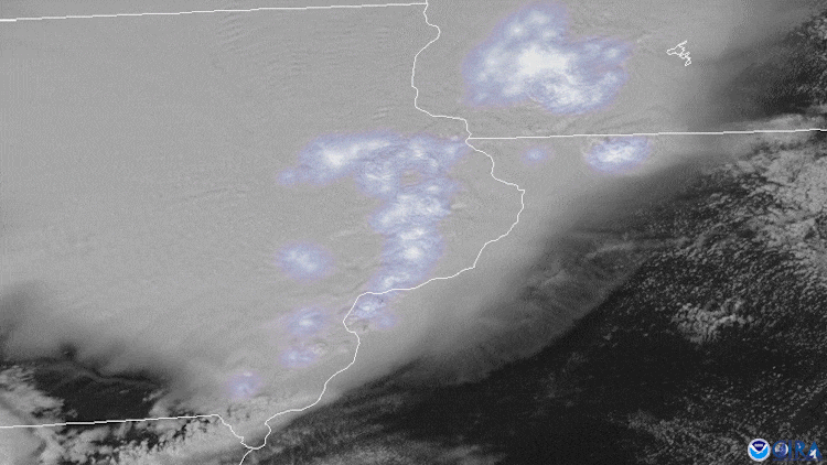
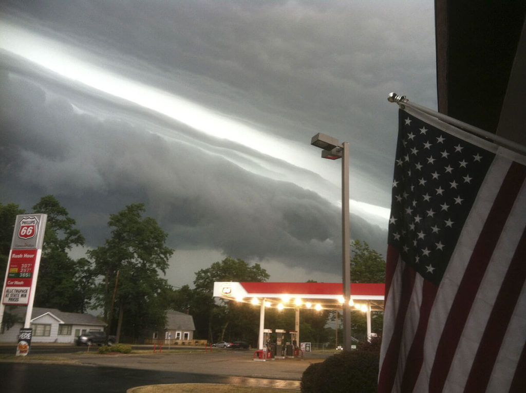
Within this MCS, the thunderstorms often form a bow echo, a radar signature that looks like a bow or crescent. This bow shape indicates the presence of strong winds pushing out ahead of the storm line. These winds are driven by downbursts and microbursts—intense downdrafts that hit the ground and spread outwards, creating powerful, straight-line winds that can exceed 100 mph. These features contribute to the extensive damage associated with derechos.
As the derecho progresses, it can maintain or intensify its strength by feeding off the warm, moist air ahead of it. The system moves quickly, typically at 50 to 70 mph speeds, covering large distances in a short timeframe. This rapid movement allows derechos to impact broad areas, often leaving a path of destruction that spans several states.
IMPACTS:
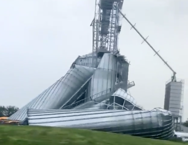
The impact of derechos can be devastating, often comparable to that of hurricanes and tornadoes. One of the most significant differences is the extent of the area affected. While tornadoes and hurricanes tend to impact more localized regions, derechos can cause widespread damage over hundreds of miles. This widespread damage makes them particularly dangerous for infrastructure, agriculture, and populations spread over a large geographical area.
The economic impact of derechos can be substantial. The cost of repairing infrastructure, homes, and businesses can run into billions of dollars. The economic toll includes immediate repairs and recovery costs and long-term effects on local economies, such as lost productivity and decreased economic activity.
While infrastructure and economic losses are significant, the human impact of derechos can be profound. These storms can result in injuries and fatalities due to falling trees, flying debris, and collapsing structures. In the aftermath of a derecho, communities often face prolonged recovery periods, during which access to electricity, clean water, and emergency services is limited.
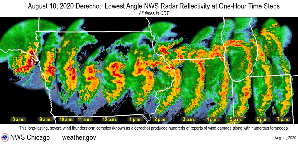
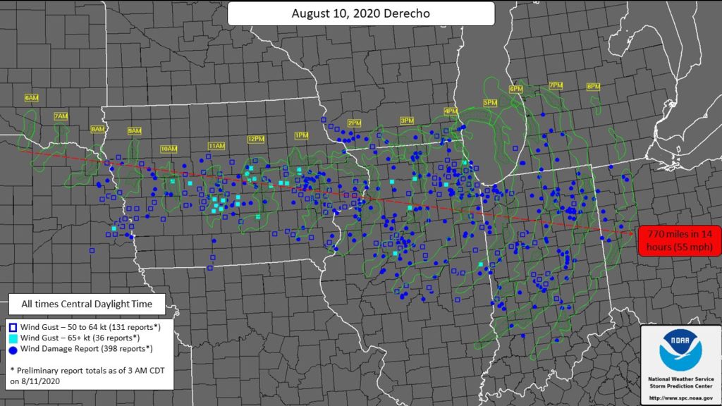
For a real-world example to help understand the significant damage done, the Midwest Derecho of August 2020 caused extensive damage across several states, including Iowa, Illinois, and Indiana, resulting in the nickname “Corn Belt Derecho.” The Corn Belt Derecho event resulted in widespread power outages, significant agricultural losses, and structural damage to homes and businesses. The total cost estimated to be $11 billion in damage, making it one of the costliest thunderstorms in U.S. history
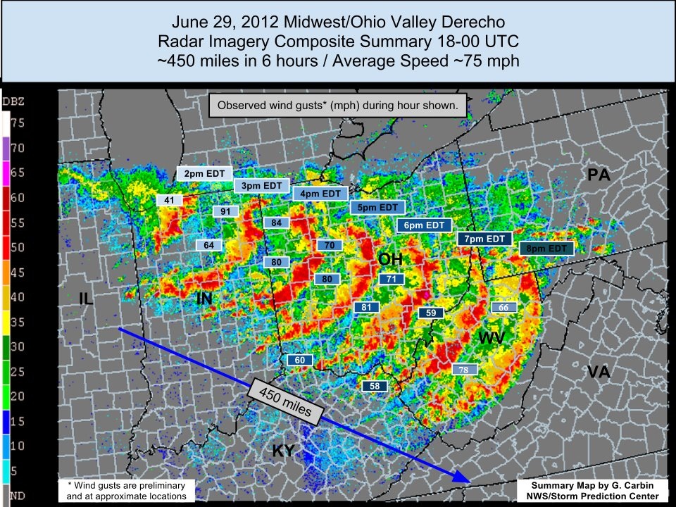
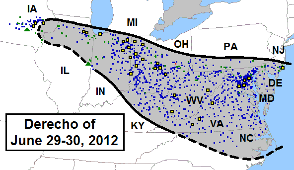
Another example is the 2012 North American Derecho, which happened on June 29 and was named “Super Derecho.” It traveled over 700 miles in about 12 hours, producing widespread wind damage and leaving a path of destruction. The storm resulted in 22 fatalities, numerous injuries, and estimated damages of $2.9 billion.
COMPARISON TO OTHER HAZARDS:
Compared to other natural hazards, derechos present unique challenges. Unlike hurricanes, which can be tracked for days before making landfall, or tornadoes, typically detected right before they form, predicting a derecho can be more complex. The rapid development and progression of the convective systems that lead to derechos make it difficult for meteorologists to provide timely warnings.

Hurricanes are large, organized systems that develop over warm ocean waters and can be tracked for several days before landfall. This extended lead time allows for more comprehensive preparation and evacuation efforts. In contrast, derechos develop more quickly and can travel over land, making it harder to predict their exact path and intensity until they occur. While hurricanes and derechos can produce powerful winds, hurricanes also bring heavy rainfall and storm surges, leading to flooding. Derechos, on the other hand, are primarily wind events, though they can also produce heavy rains and localized flooding.
Tornadoes are highly localized, short-lived events characterized by rotating columns of air extending from thunderstorms to the ground. They can produce incredibly destructive winds in a narrow path, often less than a mile wide. Tornado warnings can be issued minutes to an hour in advance, giving people a short window to seek shelter. Derechos, however, cover much larger areas, with paths extending hundreds of miles. While the individual wind gusts may not be as intense as those of the strongest tornadoes, the cumulative effect of the widespread wind damage can be more severe. The widespread nature of derechos means that many more communities can be affected simultaneously compared to a single tornado.
Moreover, the widespread nature of the damage caused by derechos differentiates them from other hazards. While floods and wildfires can also affect large areas, the intensity and speed of the winds associated with derechos can lead to more immediate and severe.
CONCLUSION:
In conclusion, derechos are significant natural hazards in the United States due to their unique formation, widespread impact, and extensive reach. While they may not be as well-known as hurricanes or tornadoes, their potential for widespread damage makes them a critical area of focus for meteorologists, emergency planners, and the public.
Understanding and preparing for derechos is essential to mitigate their impact and protect communities across the United States. By acknowledging the threat posed by derechos and adopting proactive measures, communities can better protect themselves and reduce the severe consequences of these intense and widespread wind events.
SOURCES:
National Weather Service. “Derechos: Widespread, Long-Lived Windstorms.” National Weather Service, 2023, www.weather.gov/lmk/derecho
NOAA National Severe Storms Laboratory. “Derechos.” NOAA National Severe Storms Laboratory, 2023, www.nssl.noaa.gov/education/svrwx101/wind/types/
“Midwest Derecho in August 2020: Fast Facts and Figures.” National Oceanic and Atmospheric Administration, 2020, www.noaa.gov/news/midwest-derecho-in-august-2020-fast-facts-and-figures
Squitieri, Brian Joseph, Andrew R. Wade, and Israel L. Jirak. “A Historical Overview on the Science of Derechos: Part I: Identification, Climatology, and Societal Impacts.” Bulletin of the American Meteorological Society, vol. 104, no. 10, Oct. 2023, https://doi.org/10.1175/BAMS-D-22-0217.1.
Ashley, Walker S., and Thomas L. Mote. “Derecho Hazards in the United States.” Bulletin of the American Meteorological Society, vol. 86, no. 11, Nov. 2005, https://doi.org/10.1175/BAMS-86-11-1577.


This was really cool. I was not aware how widespread these storms could be. The radar timestamps were very helpful.