Thank you for taking the time to read my second research paper of the summer! Today we’re going to be focusing on the third costliest hurricane in United States history: Hurricane Ian. Even though this may seem like your typical later-in-the-season Florida hurricane, Ian had quite the shift in track and intensity right before landfall. Unfortunately, this surprised millions in southwest Florida as they were about to get hit with a major hurricane. I’ll break down the initial forecast and how things changed leading up to landfall.
Some factors I will be looking at include specific atmospheric conditions, such as upper-level troughing, as well as surface observations. The goal is to use the synoptic data and explain why Ian’s projected landfall and intensity were difficult to forecast.
BACKGROUND:
Ian was your typical easterly wave coming off the coast of Africa in September as it slowly started to organize before reaching tropical storm status in the Caribbean Sea on September 23. The first cone was issued that day and it already hinted at the idea of a major hurricane impacting the state of Florida.
As Ian strengthened and moved off to the west-northwest, portions of Cuba were first in line to face direct impacts. Unfortunately, the western part of the island took a direct hit from a category 3 hurricane and millions of people were without power for weeks.
After moving over Cuba, Hurricane Ian now targeted the southwest coastline of Florida and quickly strengthened to a category 4 hurricane at landfall. On September 28, the storm made landfall in Cayo Costa, Florida with winds of 150 mph. Later that week, Ian made another landfall in South Carolina as a category 1 hurricane.
Overall, Hurricane Ian caused over 100 billion in damages as areas in southwest Florida and Cuba are still rebuilding to this day.
THE FIRST PART OF IAN’S FORECAST:
Let’s start off by saying Hurricane Ian wasn’t an easy storm to forecast. Credit the National Hurricane Center (NHC) for putting SW Florida in the first issued cone. So what made the storm so tough to track and predict after that? I’m going to take you through each stumbling block.
When was it going to begin the process of rapid intensification? Rapid intensification takes place with a hurricane when wind speeds increase by 35 mph or greater in 24 hours. Most major hurricanes undergo rapid intensification and this process is extremely difficult to forecast. This is one of the parts of the forecast that I thought the NHC handled pretty well. They agreed that as Ian moved into the western Caribbean towards Cuba, that’s where the greatest strengthening would take place. The NHC did well with the location of landfall in western Cuba and they were close with the intensity forecast as well, suggesting a stronger hurricane.
THE DIFFICULT PART OF IAN’S FORECAST:
WLOX 13 (2022)
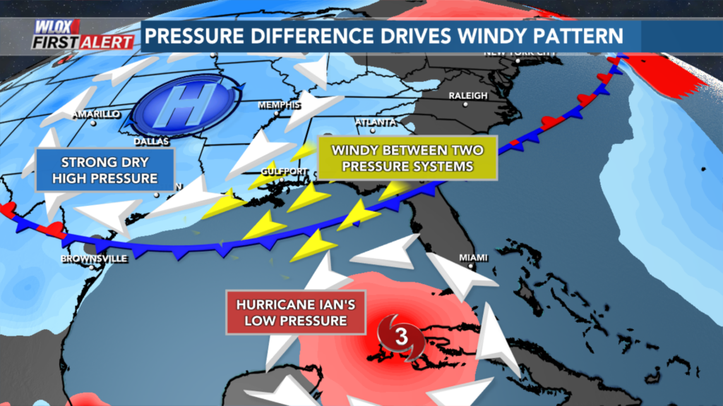
What are the synoptic features going to do to Ian? This was the most difficult part of the whole forecast. A strong upper-level trough was digging in across the Great Lakes and northeast CONUS around the same time Ian impacted Cuba. At the surface, an extremely powerful cold front made its way through the central U.S. and showed no signs of slowing down.
Models struggled with the timing of these two features drastically as they were predicting a much weaker cold front and they thought the trough would decrease Ian’s intensity. Here were the two scenarios that could’ve happened:
a. The cold front is weaker and allows Ian to turn more northward towards greater mid to upper-level shear, weakening the system to a lower-end hurricane near Tampa Bay or Cedar Key.
b. The cold front is stronger and doesn’t give Ian a northward option, so it avoids most of the wind shear and makes landfall as a stronger hurricane near Fort Myers.
If you chose option b, you’re correct. Forecasts a couple of days out had a much weaker storm making landfall near the Florida panhandle, however, by the time Ian passed over Cuba, models suddenly shifted south again and bumped up the intensity forecast. Areas from Sarasota to Fort Myers had a short window of time to make plans.
RAPID INTENSIFICATION TAKES PLACE AGAIN:
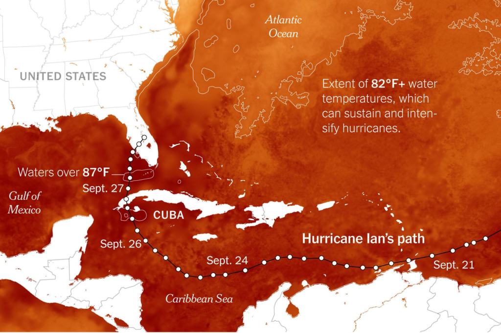
While SW Florida was quickly preparing for a major hurricane to make landfall 36-48 hours from now, Ian was in an environment primed for rapid intensification. Sea surface temperatures were near 90F and plenty of moist tropical air was in its path. There was some lower-level wind shear on the southwest side of Ian due to the aforementioned cold front, but the storm was too large by this time. Wind shear can affect the cloud tops and structure of a tropical cyclone, so the larger the size of the storm, the harder it is for a tropical system to completely fall apart. Ian’s structure was very symmetrical and had a well-defined eye.
Ian intensified from a 120 mph category 3 to a monster 160 mph category 5 in the Gulf of Mexico. The storm barely weakened to a 155 mph category 4 hurricane at landfall and the center of Ian passed just north of Fort Myers Beach.
STORM SURGE & FLOODING:
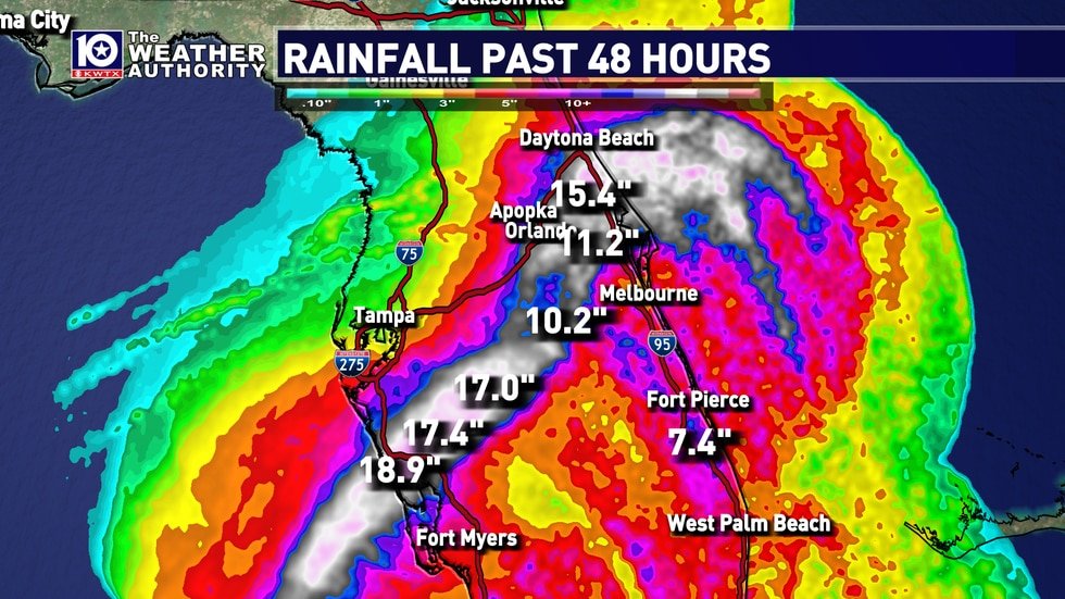
Because Ian’s landfall was just north of Fort Myers, the city was in a bad spot to experience catastrophic storm surge and flooding. The counterclockwise flow of the hurricane pushed the water out of the south-southwest well inland as totals were almost 15 feet near the beach.
KWTX 10 (2022)
In addition, Hurricane Ian was only moving at 10 mph, so this would be a prolonged event with hours of dangerous winds, storm surge, and heavy rainfall. Some locations near the center of Ian picked up over 20 inches of rainfall, so devastating impacts were felt all over central and southern Florida. Further east, areas such as Charleston, South Carolina experienced significant flooding with a storm surge of around 5 feet.
TAKEAWAYS:
Hurricane Ian was one of the most impactful storms in United States history. The strong winds, heavy rainfall, and life-threatening storm surge impacted millions from Cuba to Florida to South Carolina. A hurricane with such magnitude should always be monitored closely, so you don’t get caught off guard like many people did in SW Florida. There are so many factors that can impact the track or intensity of a tropical cyclone, so it is important to be prepared and trust your officials. Meteorologists are continuing to find the most effective ways to message information to people across the world and a system like Ian shows just how crucial it is.
SOURCES:
Bellafiore, Sean, et al. “Hurricane Ian Makes Landfall for a 3rd Time in South Carolina.” Https://Www.kwtx.com, 28 Sept. 2022, https://www.kwtx.com/2022/09/28/near-category-5-hurricane-ian-set-make-landfall-florida-today/.
Bucci, Lisa, et al. “National Hurricane Center Tropical Cyclone Report Hurricane Ian.” National Hurricane Center, 3 April 2023, https://www.nhc.noaa.gov/data/tcr/AL092022_Ian.pdf
Duncan, Carrie, and Wesley Williams. “Ian Takes Aim at Florida This Week.” Https://Www.wlox.com, 28 Sept. 2022, https://www.wlox.com/2022/09/27/ian-becomes-major-hurricane/.
Gillis, Chad. “Hurricane Ian by the Numbers: Wind Gust of 140 Mph Recorded in Cape Coral.” Press, Fort Myers News-Press, 1 Oct. 2022, https://www.news-press.com/story/weather/hurricane/2022/10/01/cape-coral-punta-gorda-hurricane-ian-wind-gust-rainfall-storm-surge-numbers/8151166001/.
“Hurricane Ian Special Summary.” National Centers for Environmental Information, Sept. 2022, https://www.ncei.noaa.gov/access/monitoring/monthly-report/national/202209/supplemental/page-5
Shao, Elena, et al. “How Hurricane Ian Became so Powerful.” The New York Times, The New York Times, 29 Sept. 2022, https://www.nytimes.com/interactive/2022/09/29/climate/hurricane-ian-florida-intensity.html.


