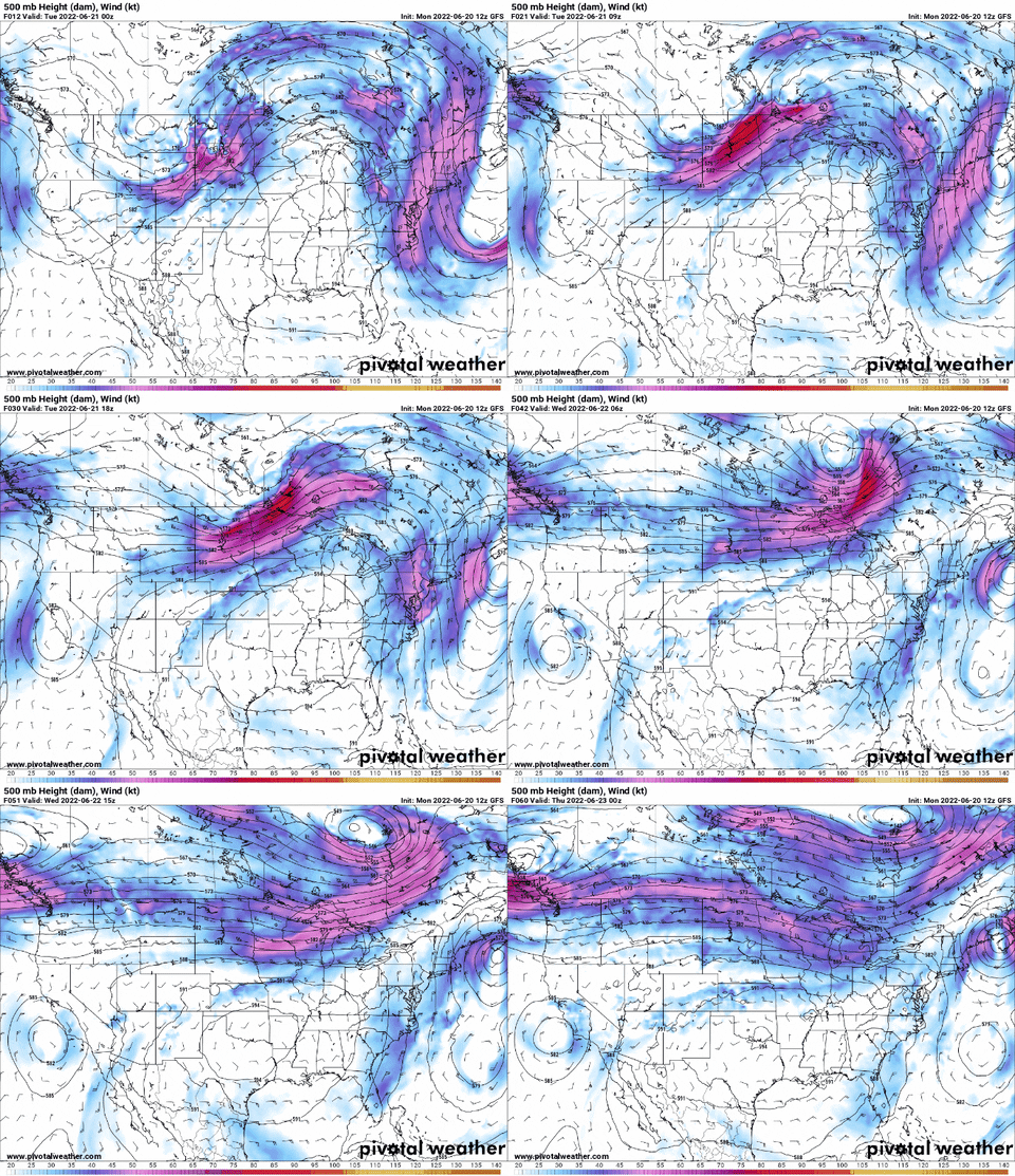
The start of this work week will feature much of the same as the previous week: oppressive heat which continues to build over the coming days.
Unfortunately for much of the southeast, the current subtropical ridge just does not want to budge, which results in the continuation of heat to build as we progress throughout the week over our forecast area.

The ridge on the GIF is visible throughout the southeast region as the enclosed area of clockwise rotation that stays over our general area. From the progression, or lack thereof, of the ridge over the area from Tuesday through Thursday, it is clear that the main concern will be how hot will it get and will there be a need for any heat advisories as the heat and humidity continues to increase throughout the upcoming week.
And it will be hot! The WPC is forecasting for max temperatures to be close to 10 degrees above average from Thursday through early next week across our area.

Looking at today, high temperatures are expected to be in the upper 90s F to near 100F across much of the region, with it being slightly cooler near the coastline thanks to onshore flow.

In terms of heat index values, they should remain at or below 105F thanks to enhanced vertical mixing during the daytime hours. This vertical mixing throughout the atmosphere allows for the drier mid-level air to mix down towards the surface, allowing the dew points to remain in the 60s F to near 70F instead of in the upper 70s.
(adsbygoogle = window.adsbygoogle || []).push({});This makes the warmth a slightly drier heat, however with temperatures still high, it will still be a scorcher outside.


Any chances for precipitation throughout the week are very sporadic and limited. Any precipitation would occur likely in the mid to late afternoon, where onshore flow will converge with flow from the north to create sea-breeze boundary. However many of the models show this to be disperse at best, and with the dynamics of large scale subsidence (sinking motion) and mid-level dry air not supportive of convective activity, thus the forecast will be mainly dry throughout the week.

Moving forward towards the weekend, the ridge beings to weaken slightly and move more toward the west. With the ridge not directly overhead, this increases the chance for potential showers and thunderstorms to impact our area. This will have to be monitored to see if this allows for any disturbances to impact our area later in the week and into the weekend.
(adsbygoogle = window.adsbygoogle || []).push({});
Day to Day Forecast
Today
Sunny and hot with highs near 100F. Heat index may reach 105F. Wind light and variable.
Tonight
Mostly clear with lows in the low to mid 70s. Wind calm.
Wednesday
Sunny and hot with a 20 percent chance of an afternoon shower or thunderstorm. Highs in the lower 100s. Heat index in the lower 100s. Wind north at 5 to 10MPH.
Wednesday Night
Mostly clear with lows in the mid 70s. Wind calm.
Thursday
Sunny and hot, with a highs in the lower 100s. Heat indexes may reach 106. Wind north 5 to 10MPH.
Thursday Night
Mostly clear with lows in the mid 70s. Wind northwest at 5MPH becoming calm.
Friday
Sunny and hot with highs in the lower 100s. Heat index may reach 104. Wind northwest at 5 to 10MPH.
Friday Night
Mostly clear with lows in the mid 70s. Wind light and variable.
Saturday
Mostly sunny and hot with highs in the lower 100s. Heat index may reach 104. Wind north 5 to 10MPH.
Saturday Night
Mostly clear with lows in the mid 70s. Winds light and variable.
Sunday
Mostly sunny and hot with a 30-percent chance at afternoon showers and thunderstorms. Highs in the lower 100s. Heat index may reach 104. Wind east 5MPH.
Sunday Night
Partly cloudy with a 20-percent chance of a shower or thunderstorm with lows in the mid 70s. Wind calm.
Monday
Mix of clouds and sun becoming more cloudy throughout the afternoon with a 40 percent chance of afternoon showers and thunderstorms. Highs in the lower 90s. Wind north at 5 to 10MPH.
Monday Night
40-percent of showers and thunderstorms with lows in the lower 70s. Wind north at 5 to 10MPH.

