All that “In like a lion, out like a lamb” or vice-versa talk about March, as a scientist, always makes me cringe. Because it is based on subjective opinion and not objective analysis. That leaves it open to observational bias and a slew of other issues. So, I will ask as a friend and your local, friendly, neighborhood meteorologist, to avoid thinking that because it is going to storm the first week in March that it will be calm at the end of March.
That being said, there is a chance for storms Tuesday and Wednesday for parts of the Gulf Coast and Southeast. The Storm Prediction Center has highlighted parts of Texas, Louisiana, Arkansas and Mississippi with a Slight Risk for severe weather.

As of now, the main concern will be heavy rain, damaging wind gusts, hail up to the size of ping-pong balls, and the potential for a few tornadoes.
It’s gon’ rain

Thanks Ollie.
As the next front swings through, it will open the door for showers and storms to develop from east Texas through Louisiana and Arkansas and into Mississippi and Alabama. But the heaviest rain may fall north and into parts of Tennessee.

The Weather Prediction Center has highlighted parts of Tennessee and Kentucky with a forecast for the highest rain totals. Note on the map above that up to seven inches of rain is possible.
The WPC notes:
Ejection of the upper trough/low expected to be near southern California as of early Mon should provide added focus/surface development by Tue-Wed. The best clustering of guidance continues to show the best potential for significant rainfall will be from the ArkLaTex region into the Tennessee Valley/lower Ohio Valley and possibly Appalachians. Some locations may see multi-inch accumulations with this event. Heaviest rainfall should occur to the north of areas that have had the most rain in the past couple weeks but this event could enhance/prolong flooding issues over and downstream from areas that see significant rainfall.
From the SPC
The Storm Prediction Center continued to hold on to the same area highlighted yesterday. So no real change from the meteorologists there. In their discussion today, they did note that the latest runs of the ECMWF may slow the system down a bit.
Medium-range guidance is in good agreement that a closed low just off the southern CA coast early D4/Monday will eject eastward across the southern third of the CONUS, interacting with a moderately moist air mass across the southern Plains and Southeast. However, variability within the guidance regarding the speed/timing of this eastward progression leads to considerable forecast uncertainty. The latest run of GFS has trended slightly more progressive with this system, bringing it across TX D5/Tuesday afternoon. In contrast, 00Z run of the ECMWF progs a much slower system reaching TX D6/Wednesday afternoon. This delay causes the shortwave to lag behind the cold front, limiting forcing for ascent over the warm sector.
Despite this variability within the guidance, model consensus exists regarding the presence of a moist and strongly sheared air mass from central TX eastward across the Southeast on D5/Tuesday, ahead of a cold front progressing southeastward. Thunderstorms are anticipated along the front, with the coverage and severity largely controlled by the proximity of the approaching shortwave trough. It seems prudent to leave the D5/Tuesday outlook area in place for this forecast, although a reduction in probability and/or area maybe in needed in subsequent outlooks if the slower trend currently progged by the 00 ECMWF appears most likely.
The data
Since the system is still about five days out, the amount of reliable data is limited. And within that data, the specificity of events needs to be handled with skepticism.

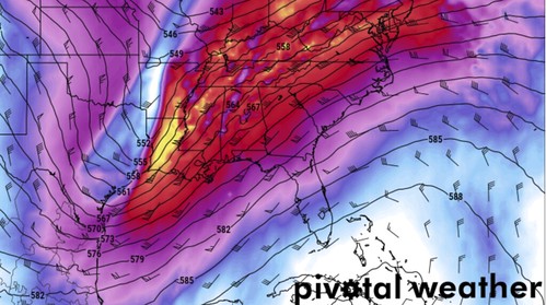
The above map from the GFS shows the upper-level (500mb) trough passing through Texas around 6p on Tuesday night. This would be the beginning of opening the door for storms to develop across the region.

Here is a look at the 500mb map for Wednesday morning around 6am. This shows the upper-level trough swinging through parts of Louisiana closing that door for everyone but Mississippi and Alabama.
The most interesting thing to note is that within the data, the best ingredients for severe weather overlap across parts of eastern Louisiana, southern Mississippi and southern Alabama around midnight Tuesday night and into Wednesday morning.

The above map shows the Supercell Composite parameter. The equation for that is SCP = (muCAPE / 1000 J kg-1) * (ESRH / 50 m2 s-2) * (EBWD / 20 m s-1). Basically what it is trying to do is take muCAPE (instability), ESRH (spin in the air), and EBWD (potential change in wind direction in a storm) to figure out how likely storms are to be organized. And, as you all know, the better organized a storm is, the better the chance it is severe.
So the higher the number / shading on the map, the better the chance a severe storm could develop.
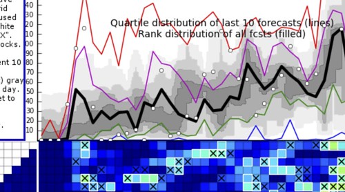
That same equation is what goes into the CFS Chiclets map I showed a few days ago.

That is a look at the updated boxes.

And that is the updated map.
This will bare watching in the coming days, and I have a feeling the true threat is going to shift northwest of its current position given how these systems tend to evolve this time of the year for our region.
The analogs
Using analogs can be very helpful. But, a lot like regular weather model data, it can change every 12 to 24 hours.
The CIPS Analogs have shown the threat for severe weather for Tuesday and Wednesday for about a full week now. And while the CIPS can’t offer specifics that may feel important, there are some really cool nuggets you can pull out of the data. I want to show you guys two maps based off of the “Experimental” CIPS Analogs. This is a great tool, but it is based on the GEFS model and the GEFS model alone. So, there are no inputs from the ECMWF, the NAM or even the regular GFS. So it has limitations.
That said, it has a history of performing pretty well. It air-balls some events, sure. But historically, it is a reliable source of weather data.

The above map shows the potential for severe storms on Tuesday. Most of the threat would be across eastern Texas, Louisiana and Arkansas. As well as parts of Mississippi and a sliver of Tennessee.

By Wednesday, that threat moves into Mississippi and Alabama. As well as Tennessee and Georgia.
This shows a 15-percent risk across the two days with a little splotch of 30-percent on Wednesday around south-central Mississippi.
Now that you’ve seen those maps, I want to show the regular CIPS data.

This may be tough to see, but these are all of the days that are used to make a comparison to the upcoming storm system. The top 15 most similar atmospheric setups. In these cases, the main concern for the region is wind. Most of the severe storm reports from past storm systems like the one coming up are wind.
There is a corridor where, historically, a tornado threat exists. But that is mainly across parts of east Texas, northern Mississippi, and northwestern and southern Alabama.

So, at this point, given the available data, even though the CIPS can’t offer specifics like, “will a tornado hit my town” it can offer you a look at where – historically – tornadoes have occurred in past systems like this one.
The Karrie Meter
For folks in South Mississippi, it is back up to a 4.16.

For the region, the Karrie Meter looks like this…
Here is the Karrie Meter map from the 12z GFS. Shows the overnight threat limited to south Mississippi and western & southern Alabama pic.twitter.com/4LdlFPhe4N
— Nick Lilja (@NickLilja) February 28, 2020
The Bottom Line
The forecast for Tuesday evening through Wednesday morning features a chance for storms and severe weather from east Texas through Louisiana, Arkansas and Mississippi. And that probably includes Alabama and parts of Tennessee, too.
Specifics about this system are currently unknown. Things are likely going to need to be massaged and changed in the coming days. The timeline, the risks, etc are all going ot shift slightly here and there.
As of now, the main concerns are for heavy rain (including potential flooding for some places), frequent lightning, wind gusts up to 70mph, hail up to the size of ping-pong balls, and the potential for tornadoes.
For some places this may be an overnight event, so make sure you have a NOAA Weather Radio, a weather alert app on your phone, or some other means to be woken up if a tornado warning is issued.

