We have another round of showers, storms, and severe weather expected across the region tomorrow afternoon and evening. The Storm Prediction Center (SPC) has placed most of the area under an Enhanced Risk for severe weather—a Level 3 on the 1-to-5 scale, where 5 represents the highest risk for significant severe storms.
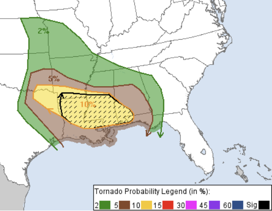
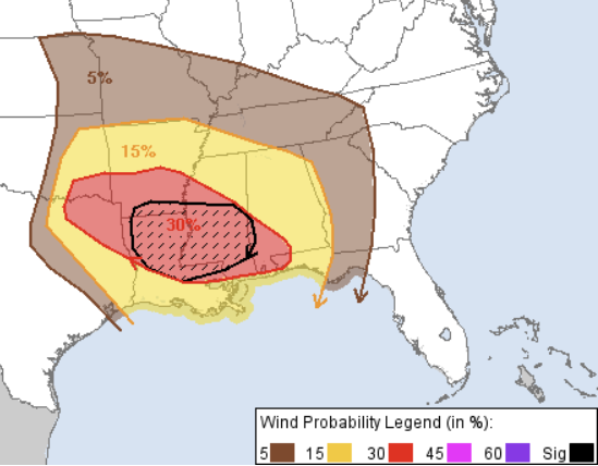
The SPC has also highlighted our area with a 10% hatched risk for strong tornadoes and a 30% hatched risk for damaging winds.
While this isn’t a guaranteed outbreak of tornadoes or damaging winds, the risk is high enough to warrant serious attention and this level of concern from the SPC.
TIMELINE & THREATS
We have seen the timing really speed up on some of the hi-res guidance. This is both good news and bad news for our area. The good news is fewer folks will have storms moving through during the overnight hours. The bad news is these storms will really need the daytime heating to get going and will benefit (greatly) from any added warmth they can get. This is a situation where the overnight risk may actually be lower than the daytime risk – even when consider you can’t see tornadoes at night.
Estimated Timing:
Midday: Central Louisiana & Western Mississippi
Afternoon: Central & Southern Mississippi, Southeastern Louisiana
Evening: Southeast Mississippi & Western Alabama
Overnight: Central and Eastern Alabama
What to Expect:
Everyone: Brief heavy rain, some lightning, wind gusts up to 40 mph
Most Places: Brief heavy rain, some lightning, wind gusts up to 50 mph
Many People: Prolonged heavy rain, frequent lightning, wind gusts up to 55 mph
Some Folks: Prolonged heavy rain, frequent lightning, wind gusts up to 60 mph, small hail
A Few Spots: Multiple rounds of heavy rain, frequent lightning, wind gusts up to 75 mph, large hail, a tornado
The main concern for most will be brief heavy rain, lightning, and potential wind gusts up to 60 mph. Not everyone will see that level of wind, but it’s the primary risk.
Tornado Threat:
There is a chance for a few tornadoes tomorrow, but for our area, that risk looks more conditional. The SPC’s concern is valid—the wind field throughout the atmosphere is supportive of severe storms and the production of tornadoes, including strong tornadoes. However, we may end up with too much wind relative to instability.
In past events, we’ve seen situations where strong wind shear overwhelms the updrafts, tilting them too much for storms to efficiently mix severe winds down to the surface and disrupting the balance between the updraft and downdrafts needed to produce a tornado. That scenario is possible again this time.
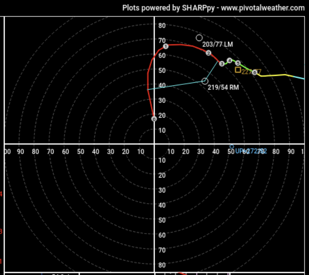
But here is how is shakes out visually:
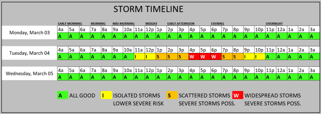
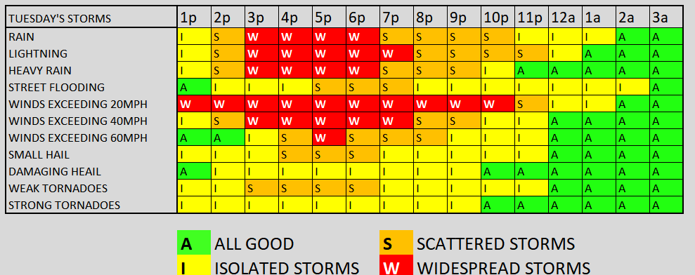
And here is a look at how that timeline shakes out with the specific threats
FAILURE MODES
Like I said, this isn’t a slam dunk. There are a few factors that could limit the potential for significant severe weather. That doesn’t mean you shouldn’t pay attention when storms develop, but if certain things don’t line up, we might miss out on the worst of the worst.
Too Much Wind
As I mentioned, we may have too much wind—not at the surface, but higher up. Wind shear and helicity help storms organize by allowing rain to fall in one part of the storm while warm air is pulled up into another. But sometimes, if the winds aloft are too strong or misaligned, and the updrafts are weaker, those winds can tilt the updrafts too much.
Teh hodograph below shows wind up to 65kts above the surface, but this might be too strong.
There’s a delicate balance required for tornado formation. While it’s easy to create in general, it’s much harder to pinpoint exactly when and where conditions will be just right for a tornado to form. Predicting which storm will reach that balance is even tougher. (As an aside, this is why it’s so difficult to answer the question I get occasionally: “Is it going to tornado or not? Just tell us.”)
Not Warm Enough
There’s a chance we won’t get warm enough tomorrow, even with daytime heating and a steady south wind at 20 mph all day long.
This air mass isn’t deep, tropical moisture from the Caribbean. Instead, it’s recirculated air from Ohio—yes, Ohio. About 72 hours ago, this air was over the Midwest, then it got flung out over the Gulf and is now being pulled back northward.
Because of that, we aren’t tapping into the rich, warm, humid air that fuels more intense storms. Adding to that, the air about 4,000 feet up is coming from near the Yucatán, which is actually warmer. But when you put warmer air above cooler air, it creates stability, not instability—essentially suppressing storm development.
This sKew-T profile is actually pretty robust. But it is missing one thing, strong surface-based instability.
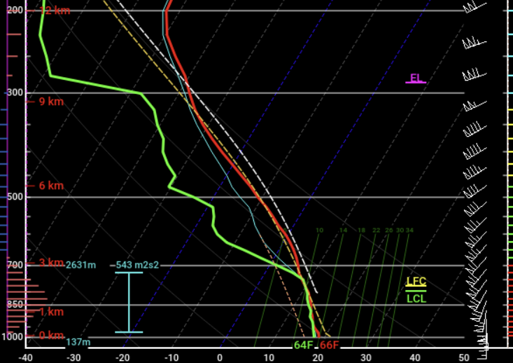
That means we could see a lot of elevated storms tomorrow, with only a handful being surface-based. If we don’t warm up enough, that will keep the most intense storms limited. But if we get more sunshine, it will increase the instability and give us more to worry about.
So if you see the sun tomorrow, it doesn’t mean “the forecast is wrong.” It just means “the forecast isn’t correct yet.”
Fast-Moving Storms
Storms tomorrow may be moving so fast that they don’t have time to do extensive damage the way slower-moving, longer-lasting storms can. Instead of dealing with 70 mph wind gusts for 5 to 15 minutes as a storm moves through, you may just get one sudden 70 mph gust as the storm races by.
Storm motion could be highway speeds, which means two things:
If a storm is not surface-based, it will still produce wind, but it will be in and out so fast you might think, “That’s it?”
If a storm becomes surface-based, it will have no trouble mixing down a 70 mph wind.
Putting it all Together
All of that together means when looking at the Updraft Helicity Streaks, that what you see may not be as worthwhile a descriptor as it normally is.
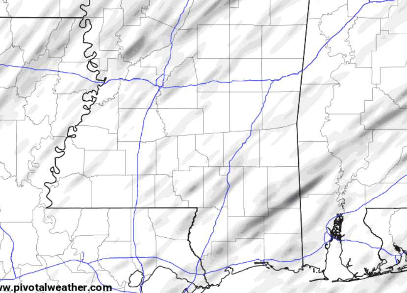
Because this map shows where the computer thinks the strongest storms will be, but it doesn’t tell you if those storms are surface-based or tilted too much.
BOTTOM LINE
Severe storms are possible tomorrow, but the extent of the threat depends on several key factors. If we warm up enough and storms can tap into surface instability, damaging winds and tornadoes will be a bigger concern. However, if cooler air and excessive wind shear disrupt storm organization, the severe threat may be more limited.
Either way, expect fast-moving storms with heavy rain, frequent lightning, and gusty winds, with a few areas seeing more intense impacts. Stay weather-aware, and don’t let the uncertainty keep you from being prepared.


We as contractors rely on past weather data for contract extensions as well as accurate forecast for roofing operations on a daily basis.