I might be saying two different S-words in the coming days.
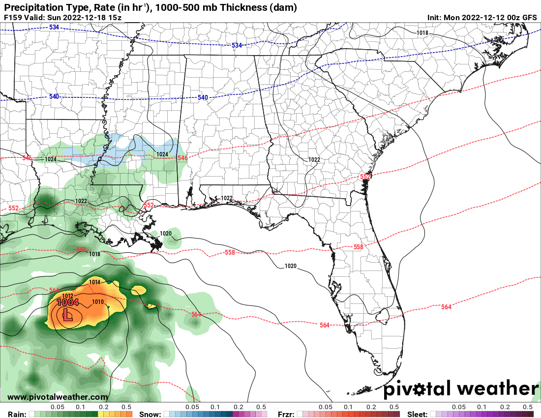
First we have a battle with severe weather on Tuesday night and through Wednesday. Then — and I’ve kicked this can down the road for a few days now without saying anything — we may have our first chance to see some ice crystals / tiny snow flurries of the season by this weekend. It is still a pretty low chance, but its the first shot of the season.
And I would argue the chance that your house sees a snow flurry is about as high as the chance that your house sees a tornado.
But let’s talk about the severe weather potential really quickly. Here are the maps from the SPC:


An Enhanced Risk for most of Louisiana. The Slight Risk clips most of southern Mississippi across both days and Alabama on Wednesday. The Marginal Risk has a bit wider spread.
The interesting part to me, currently, within the model guidance is the slow-down of the storms on Tuesday night and into Wednesday morning. This has been shown across the Euro and GFS and is now also being shown in some of the high-res guidance, too.

This would likely increase the risk for severe weather across southern Mississippi and Alabama. It would also change the timeline of events for some folks, too. It would really limit the chance for storms on Tuesday to be more isolated and much lower. And it would really increase the chance for storms on Wednesday.
Looking at the sounding data, it suggests a decent severe weather environments ahead of the storms Wednesday afternoon, too.

I think the takeaway from the data is “slower storms, more severe” for Wednesday. And “faster storms, less severe” for Tuesday night into Wednesday morning.
And that is specifically for our coverage area. The speed of the storms is irrelevant to the threat for severe weather Tuesday before 10pm for the rest of the risk area. But, given the data, here is a look at the timeline for threats:

After all of this is done, we get some cooler air to settle into the area. Just how cold is still a bit in question. And the specific storm track of the next system is also in question. As is the timing.
But, again looking at the latest data, there is a chance the next system slides back across the Gulf. That would leave the cooler air in place and allow for some precip to overrun the cooler air which may allow for a few ice crystals or snow flurries to occur late Saturday night and into Sunday morning.


That said, the modal guidance is still unsure about there even being precip in the area. So we still ahve plenty of time to shake this one out.
DAY TO DAY FORECAST
Today
Mostly cloudy. A slight chance of showers this morning. Patchy dense fog this morning. Highs around 70. Northeast winds around 5 mph. Chance of rain 20 percent.
Tonight
Mostly cloudy. Near steady temperature in the upper 50s. East winds around 5 mph.
Tuesday
Mostly cloudy. A chance of showers in the afternoon. Highs in the mid 70s. Southeast winds 5 to 10 mph with gusts up to 20 mph. Chance of rain 30 percent.
Tuesday Night
Cloudy. A chance of showers with a slight chance of thunderstorms in the evening, then showers with a chance of thunderstorms after midnight. Near steady temperature in the mid 60s. Southeast winds 5 to 10 mph with gusts up to 25 mph. Chance of rain 80 percent.
Wednesday
Showers and thunderstorms. Highs in the lower 70s. South winds 5 to 10 mph with gusts up to 30 mph. Chance of rain near 100 percent.
Wednesday Night
Mostly cloudy with showers and thunderstorms in the evening, then partly cloudy with a slight chance of showers and thunderstorms after midnight. Much cooler with lows in the upper 40s. Chance of rain 80 percent.
Thursday
Sunny, cooler with highs in the lower 60s.
Thursday Night
Mostly clear. Lows in the upper 30s.
Friday
Sunny. Highs in the mid 50s.
Friday Night
Mostly clear. Lows in the mid 30s.
Saturday
Mostly sunny. Highs in the lower 50s.
Saturday Night
Mostly cloudy. A slight chance of rain showers after midnight. Lows in the mid 30s. Chance of rain 20 percent.
Sunday
Partly sunny with a 20 percent chance of rain showers. Highs around 50.

