So I’m sure every social media meteorologist has been going crazy over Saturday’s severe weather event due to a multitude of factors. I’m not here to confirm or deny any of their claims, but I will tell you my observations. This forecast isn’t a doozie, but it’s a little harder to pin down due to the nature of it. First, let me tell you about the rest of the work week and then we can dive in.
Starting tonight, the gradient winds I mentioned on Monday will begin to roll in as an upper level trough moves in and brings a small chance of rain to parts of Mississippi. Some rain and possible thunderstorms will be possible in the morning hours. Afterwards, Thursday will be a more windy day with gusts up to 20mph and clouds clearing out during the day with a high in the low 80s. Thursday night into Friday morning will be noticeably warmer with lows in the upper 50s and winds moving from the South.
I’m not gonna lie, pinning down Friday’s severe threat has been a challenge, but I’m assuming that the warm sector has a lot to do with it. I noticed some storms developing due to the winds out of the south with favorable conditions for severe weather from the Skew-T’s. I wouldn’t doubt we’ll get some isolated severe thunderstorms, but I think the main threats will be slightly north of us towards I-20. Overnight, we’ll see part of the main front move in bringing more storms. All the risks are on the table for Friday night including gusty winds, localized heavy rain, hail, and a possible tornado. It’ll be something to watch out for and I’ll go into more detailed analysis once the short-range models are in range. It’ll be a very warm day with temperatures in the low to mid 80s and winds gusting out of the South.
Severe Weather Saturday
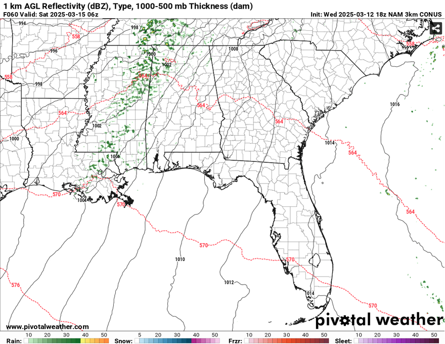
The warm sector will move further north into the Midwest leaving us with the main cold front to contend with. Not only that, a surface low will move in from northeastern Mexico bringing a strong gradient of wind at the surface and more moisture to compound with the Atlantic high. As the low moves from the Gulf, it will mature and close causing an organized MCS development across the Gulf South. The ingredients are all here for severe weather to happen.
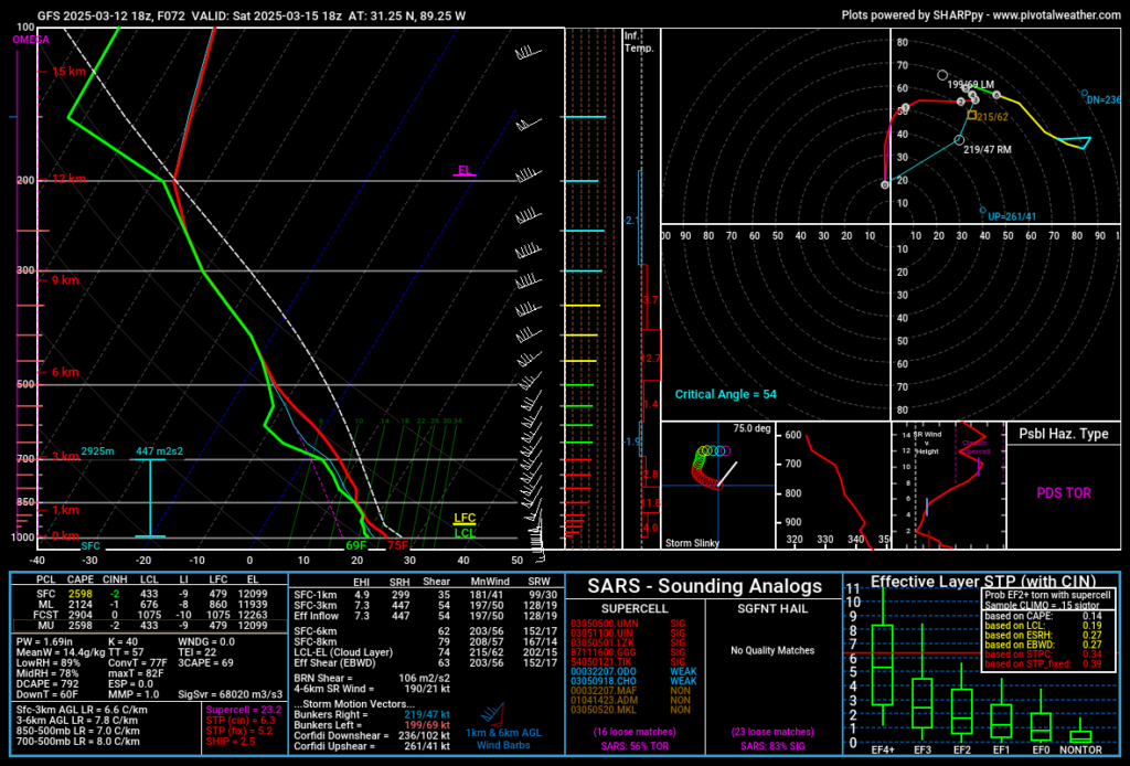
Okay, before we go full doom-mode here, I need to make this clear. The GFS and NAM models have been pretty aggressive on this event. The European model has toned it down a bit, but it still implies probable severe weather. The helicity, instability, dewpoint, and hodographs are pretty much there.
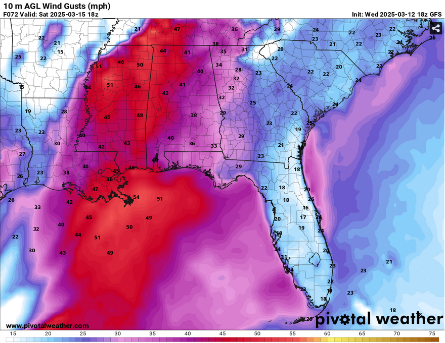
Do I think we’ll see some severe weather? Yes, I think it’s pretty likely. Some tornadoes will be possible, and the NWS in Jackson implies that there could a possibility of a strong tornado. Hail is possible considering the dry slots in the atmosphere. Wind gusts up to 50mph and even up to 70 may be possible. Heavy rain and localized flash flooding may also be possible. This looks to last most of the day starting in the mid-morning and lasting until the early evening.
The main ways I think that the severe threat could be weakened is in the same way that we dealt with last time, the speed of the storms and the wind inflow. If the winds are too strong, they may hinder tornado development a bit. The speed of the storms may also inhibit the severity. Don’t put your eggs all in one basket for this, though.
Sunday and the Work Week
As the cold front moves out Saturday night, we’ll see a brief period of milder temperatures with winds out of the northwest on Sunday. Highs will be in the low 70s and lows in the low 40s. The surface ridge will move in on Monday keeping temperatures on the mild side on Monday with highs in the low 70s and lows in the mid 40s. The clouds will roll in starting Tuesday with highs in the upper 70s and lows climbing to the low 50s. By Wednesday, we’ll reach the 80 degree point with more clouds and south winds.
Select Data Set:

Regional Day-to-Day Forecast
Tonight – A slight chance of showers between 3am and 4am. Increasing clouds, with a low in the mid 50s. South wind 5 to 10 mph, with gusts as high as 20 mph. Chance of precipitation is 20%.
Thursday – Areas of fog before 7am. Otherwise, mostly cloudy, then gradually becoming sunny, with a high in the low 80s. Southwest wind 5 to 10 mph, with gusts as high as 20 mph.
Thursday Night – Increasing clouds, with a low in the upper 50s. South wind around 5 mph.
Friday – Partly sunny, with a high in the low to mid 80s. South wind 5 to 10 mph increasing to 10 to 15 mph in the afternoon. Winds could gust as high as 30 mph.
Friday Night – Showers likely, with thunderstorms also possible after 4am. Mostly cloudy, with a low in the mid 60s. South wind 10 to 15 mph, with gusts as high as 30 mph. Chance of precipitation is 60%. New rainfall amounts of less than a tenth of an inch, except higher amounts possible in thunderstorms.
Saturday – Showers and possibly a thunderstorm. Some of the storms could be severe. High in the upper 70s. South wind 10 to 15 mph, with gusts as high as 30 mph. Chance of precipitation is 90%. New rainfall amounts between a half and three quarters of an inch possible.
Saturday Night – Scattered showers and thunderstorms before 1am. Some of the storms could be severe. Partly cloudy, with a low in the low 50s. West southwest wind 5 to 15 mph, with gusts as high as 25 mph. Chance of precipitation is 30%.
Sunday – Sunny, with a high in the low 70s. Northwest wind 5 to 10 mph, with gusts as high as 20 mph.
Sunday Night – Clear, with a low in the low 40s. North northwest wind around 5 mph.
Monday – Sunny, with a high in the low 70s
Monday Night – Mostly clear, with a low in the low to mid 40s.
Tuesday – Sunny, with a high in the upper 70s.
Tuesday Night – Partly cloudy, with a low in the low 50s.
Wednesday – Partly sunny, with a high near 80.


