A frosty start to the day will quickly give way to warmer temperatures under sunny skies and increasing southerly winds. Even after all the rain, the wind will contribute to a limited to elevated fire danger north of I-20.
Saturday remains quiet, with surface ridging moving east across the region. By Sunday, a closed low over the Northern Plains will shift toward the Great Lakes, pushing a cold front eastward into the western parts of the forecast area. Strong to severe storms are possible ahead of this front Sunday afternoon and evening due to instability, wind shear, and dewpoints in the low 60s.
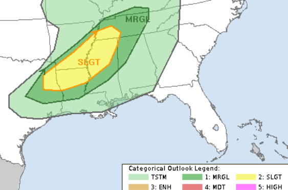
Model agreement is improving, though timing differences remain—Euro guidance is slightly faster than the GFS. The SPC Slight Risk (2 of 5, where a “5” is the highest risk for the most significant severe weather) for severe storms has shifted northward and now includes parts of north central and northwest Mississippi, southeast Arkansas, and northeast Louisiana. The Marginal Risk (Level 1 of 5) has also shifted northward, removing most of the Pine Belt from risk areas. That does’nt mean we are out of the woods for storms – nor for storms that may pack a bit of a bite – but it does mean that the risk for more substantial severe weather is lower.

Model guidance continues to show this to be a late evening or overnight threat Sunday night through Monday morning. Damaging winds and hail are the main threats. That also means any plans for Sunday for outdoor activities are probably okay. I’d have a back-up plan just in case, but no reason to make wholesale changes given the model guidance at this time.
In fact, there is even some evidence to suggest this may linger around north of us and not press all the way through until you head to work Monday morning.
Monday through late week, showers may linger in the southeast as the cold front exits. Cooler, drier air moves in Monday afternoon, followed by a quiet pattern through midweek. By late week, temperatures and moisture gradually increase ahead of a dry cold front expected to move through the region from the Tennessee Valley.
A pretty good-looking Spring Break!
REGIONAL DAY-TO-DAY FORECAST
Today: Areas of frost this morning. Sunny. Highs in the upper 60s. Northeast winds around 5 mph, becoming south this afternoon.
Tonight: Clear. Not as cool with lows in the mid 40s. Southwest winds 5 to 10 mph.
Saturday: Sunny. Not as cool with highs in the upper 70s. Southwest winds 5 to 10 mph.
Saturday Night: Mostly clear. Lows in the lower 50s. South winds 5 to 10 mph.
Sunday: Mostly sunny. Highs in the upper 70s. South winds 10 to 15 mph with gusts up to 25 mph.
Sunday Night: Partly cloudy in the evening, then mostly cloudy with showers likely after midnight. Not as cool with lows in the lower 60s. Chance of rain 70 percent.
Monday: Mostly cloudy. A chance of showers and thunderstorms in the morning. Highs in the mid 70s. Chance of rain 50 percent.
Monday Night: Partly cloudy. Lows in the lower 50s.
Tuesday: Sunny. Highs around 80.
Tuesday Night: Mostly clear. Lows in the mid 50s.
Wednesday: Sunny. Highs in the lower 80s.
Wednesday Night: Mostly clear. Lows in the lower 50s.
Thursday: Sunny. Highs in the lower 80s.


