With some cooler weather today, you’d think that there wouldn’t be any severe weather tomorrow. However, the Storm Prediction Center has put us under an Enhanced Risk (3/5) for severe weather tomorrow.
The biggest reason for this is high winds and the chance for tornadoes. Models are sending mixed signals for tornado development, but it’s absolutely possible that there will be a few that will develop and even a few strong tornadoes considering the environment. However, like Nick mentioned, there is a delicate balance to form a field capable of tornado development.
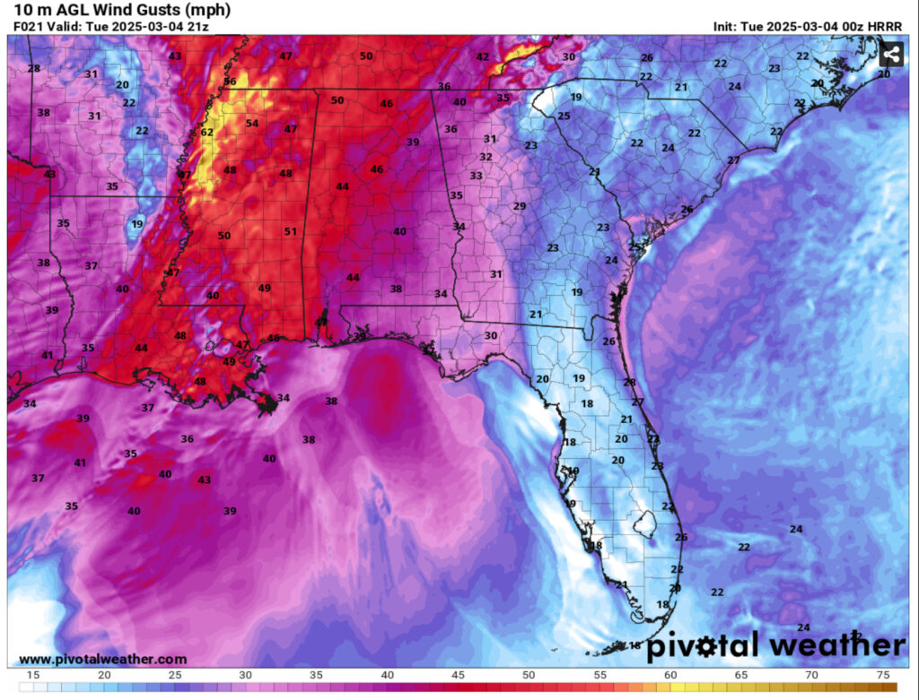
The first thing is the mixing in the upper levels. There’s plenty of shear to be had with higher than average winds at the surface and 70+ knot winds at the 500mb level. This is prime for high wind gusts across much of the northern Delta as well as 40+ mph wind gusts in the south end of Mississippi. So easy to say, falling limbs off of trees and power outages will likely happen. Heavy rain and lightning are also a concern for tomorrow with a decent amount of instability developing from the thunderstorms. It will be mostly localized flooding from the thunderstorms.
Overall, I think this will be a decent day for severe weather but mainly if we get enough instability from the sun before the storm system arrives. The HRRR model shows the line splitting as it moves towards Mississippi indicating that it will begin to lose steam. This will likely change as we go forward tomorrow especially if/when conditions change. The speed of these storms will bring enough high winds and heavy rain to us but may limit the tornado development.
The Rest of the Week
After the storm system moves out, we’ll have another cool, gusty day as a high pressure zone from Canada takes over the entire central US. With an already tight gradient left over from the low pressure, we’ll experience some wind gusts up to 30 mph during the day with temperatures just reaching the low 60s. Lows will fall into the upper 30s with west northwest winds still blowing overnight.
Thursday will be cool, but more calm as the high pressure moves over the Deep South inhibiting the winds for the day. Highs will be in the mid 60s and lows in the low 40s. As the high moves towards the Atlantic, the gradient will allow some strong southern winds to move into our area with winds gusting into the 20s and temperatures into the 70s. The clouds will be increasing during the day. Models are still on a different wavelength to see whether there will be moisture associated with the low pressure system that develops out of the southern Rockies. The GFS suggests there is rain and possible thunderstorms moving in on Saturday while the Euro shows no such thing, but as the week moves on, we’ll see the models agree more on the upcoming system.
Regional Day-to-Day Forecast
Tonight – Mostly cloudy, with a low in the low 50s. Southeast wind 5 to 10 mph, with gusts as high as 20 mph.
Tuesday – A chance of rain and thunderstorms before 4pm, then rain likely and possibly a thunderstorm between 4pm and 5pm, then showers and possibly a thunderstorm after 5pm. High in the mid 70s. Windy, with a south southeast wind 10 to 15 mph increasing to 20 to 25 mph in the afternoon. Winds could gust as high as 40 mph. Chance of precipitation is 80%. New rainfall amounts between a tenth and quarter of an inch, except higher amounts possible in thunderstorms.
Tuesday Night – Showers likely and possibly a thunderstorm before 9pm. Cloudy during the early evening, then gradual clearing, with a low in the low 50s. Southwest wind 15 to 20 mph decreasing to 10 to 15 mph after midnight. Winds could gust as high as 35 mph. Chance of precipitation is 70%. New precipitation amounts between a tenth and quarter of an inch, except higher amounts possible in thunderstorms.
Wednesday – Sunny, with a high in the low 60s. West wind 15 to 20 mph, with gusts as high as 30 mph.
Wednesday Night – Clear, with a low in the upper 30s. West northwest wind 5 to 10 mph, with gusts as high as 25 mph.
Thursday – Sunny, with a high in the low 60s. North wind around 5 mph becoming calm in the afternoon.
Thursday Night – Mostly cloudy, with a low in the low 40s. Calm wind.
Friday – Partly sunny, with a high in the mid 70s. Light south southeast wind becoming south southwest 10 to 15 mph in the morning. Winds could gust as high as 20 mph.
Friday Night – A 20 percent chance of showers after midnight. Mostly cloudy, with a low in the mid 50s. South wind 5 to 10 mph.
Saturday – A 40 percent chance of showers. Partly sunny, with a high in the low 70s.
Saturday Night – A 20 percent chance of showers. Mostly cloudy, with a low in the mid 40s.
Sunday – Mostly sunny, with a high in the mid 60s.
Sunday Night – Mostly clear, with a low in the low 40s.
Monday – Sunny, with a high in the low 70s.


