A weak cold front is moving southward today, bringing drier air with it by the afternoon and evening. For areas south of Interstate 20, it will still be pretty hot, with temperatures reaching the lower 90s and feeling like close to 100 degrees in some places. North of the Interstate, it’ll be slightly cooler and less humid, with heat index values around 85-90 degrees.
There’s a chance of showers or storms, especially near the Gulf Coast, but they’ll taper off in the evening as drier air moves in. Overnight temperatures will drop into the 60s, possibly even upper 50s in some spots, making for a pleasant summer evening.
For the rest of the week into the weekend, we’ll see upper level troughing in the atmosphere, which means “cooler” and “drier” air will be moving into our region behind the cold front. Both of those are in quotes because they should probably read “not as hot” and “not as humid” instead. Rain chances have shifted southward and should hug the coast for most of the week, with any significant impacts from disturbances in the Gulf of Mexico not expected until late in the week or the weekend.
Temperatures will be slightly cooler on Tuesday and Wednesday, with highs in the mid to high 80s for most areas, while some areas in the Pine Belt may still reach the low 90s.
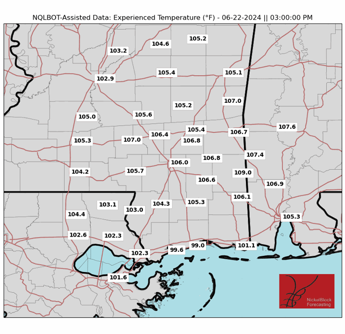
By Thursday, temperatures will start to warm up again as southerly winds bring in warmer air from the Gulf. Rain chances will remain low, mostly to our south. By Friday and Saturday, temperatures could climb to the upper 90s, making it possibly the hottest days of the year so far for some folks. While there’s no official Heat Advisory has been issued yet, i bet we see something by later this week. Some of these “Experienced Temperatures” on Friday look disrespectful.
All the while, we have eyes on what is happening in the Tropics. So far we don’t have anything to worry about, just two areas to monitor.

For more info about that, you can check out the Tropical Update from last night.
REGIONAL DAY TO DAY FORECAST
Today: Mostly sunny. A chance of showers and thunderstorms this afternoon. Highs in the mid 90s. Northwest winds around 5 mph. Chance of rain 30 percent.
Tonight: Mostly cloudy with a shower or storm possible. Lows in the upper 60s. North winds around 5 mph. Chance of rain 20 percent.
Tuesday: Sunny. Highs in the lower 90s. North winds 5 to 10 mph.
Tuesday Night: Mostly clear. Lows in the mid 60s. Northeast winds around 5 mph.
Wednesday: Sunny. Highs in the lower 90s. Northeast winds around 5 mph.
Wednesday Night: Mostly clear. Lows in the mid 60s.
Thursday: Sunny. Highs in the mid 90s.
Thursday Night: Mostly clear. Lows around 70.
Friday: Sunny. A slight chance of showers and thunderstorms in the afternoon. Highs in the upper 90s. Chance of rain 20 percent.
Friday Night: Mostly clear. Lows in the lower 70s.
Saturday: Sunny. A chance of showers and thunderstorms in the afternoon. Highs in the mid 90s. Chance of rain 30 percent. Heat index values up to 105.
Saturday Night: Partly cloudy with a slight chance of showers and thunderstorms. Lows in the mid 70s. Chance of rain 20 percent.
Sunday: Mostly sunny. A chance of showers and thunderstorms in the morning, then showers and thunderstorms likely in the afternoon. Highs in the upper 80s. Chance of rain 40 percent.


