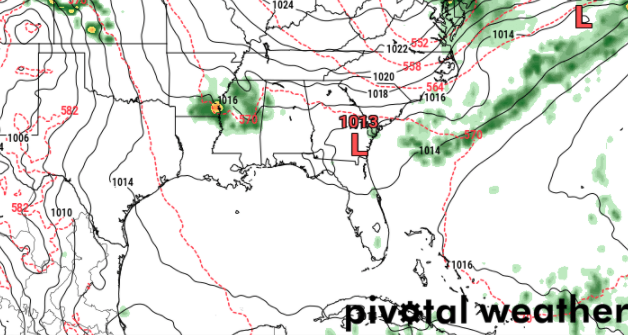
The strong ridge of high pressure that continues to hang out in south Mississippi – because who wouldn’t want to? – will finally get the nudge to move along by Friday. This will allow a leftover front to swing through the area with some showers and storms.
The timing for the front is a bit uncertain at this point, though. For now, I’m going to stick with a Saturday arrival. There is some indication that it may hold off until as late as Tuesday of next week.

Regardless of timing, when it shows up, it will shove the current ridge out and allow a more subtropical air mass to build into the area. That means a bump in daily chances for rain as well as a boost to our humidity.
Day-by-Day Forecast
Today
Patchy fog in the morning, then clearing this afternoon. Highs around 90. South winds 5 to 10 mph.
Tonight
Clear in the evening then becoming partly cloudy. Lows in the mid 60s. South winds around 5 mph.
Wednesday
Mostly sunny. Highs around 90.
Wednesday Night
Mostly clear and rather mild. Lows in the upper 60s.
Thursday
Sunny. Highs around 90. .
Thursday Night
Mostly clear. Lows in the upper 60s.
Friday
Partly cloudy with a 20-percent shot for some afternoon storms. Highs around 90.
Friday Night
Any showers and storms should end by 9pm leaving the area under partly cloudy skies. Lows in the upper 60s. The chance of rain 20-percent.
Saturday
Leftover showers and storms along a falling-apart-front will press through the area. Highs should be held in check by the rainfall and only tag the mid 80s. The chance of rain 50-percent.
Saturday Night
Partly cloudy. Lows in the mid 60s.
Sunday
More afternoon showers and storms possible. The chance for rain is around 20-percent. Highs in the upper 80s.
Sunday Night
Mostly clear. Lows in the mid 60s.
Memorial Day
Partly cloudy and warm. Highs in the upper 80s.


Just looked at the latest model run on Tidbits and it is showing the front moving through on Saturday. I guess, as ‘you’ would say, we’ll see. Thank you, again, for the daily updates. Hope you’re doing OK.