Welcome to Hurricane Season. Coincidentally, this year, it is also the start to out ‘there is a chance for rain every afternoon’ season, too.
It looks like, as anticipated, one ridge of high pressure has moved out leaving the door open for much more humid air to be shoved into the region. It won’t be felt immediately, but the last few days, we have been able to ‘mix down’ some drier air as the daytime heat drives the humid air at the surface up.
But during the day today, the drier low-level and mid-level air will be replaced by humid air, which means we will be mixing down air that is just as humid. So we won’t be able to enjoy the afternoon sun as much anymore.
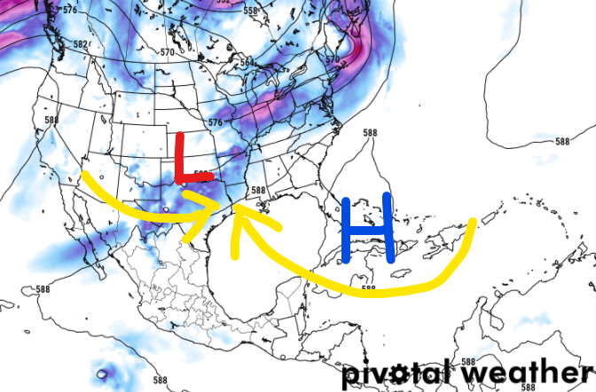
And at the surface, with high pressure setting up to our southeast, we will start to build in air from the Gulf and Caribbean. Also, much more humid.

With an area of low pressure developing to the west, this will set the stage for afternoon storms to return. Almost every day.
All the while, not that we are in Hurricane Season, we will have to keep tabs on what may by brewing in the Tropics. So far, it looks like things will remain pretty quiet during the next five days, but once we get into the Day 9 – Day 15 timeframe, things look like we may see something try to develop near (or in) the Gulf.
Remember, NOAA and Colorado State meteorologists are forecasting an above average season. So please keep tabs on the Tropical Forecast! And don’t go more than a few days this summer without checking in to make sure something ‘new’ hasn’t popped up.
Day-by-Day Forecast
Today
Patchy fog in the morning. A 20-percent chance of showers and thunderstorms in the afternoon. Partly cloudy. Highs in the upper 80s. South winds 5 to 10 mph.
Tonight
Mostly cloudy with lows in the upper 60s.
Wednesday
Partly to mostly cloudy. Mild and more humid. Highs in the mid 80s. South winds 5 to 10 mph. The chance of rain 40-percent.
Wednesday Night
Mostly cloudy with a few lingering showers possible. Lows in the upper 60s. Chance for rain will be around 20-percent.
Thursday
Mostly cloudy with a 60-percent chance for showers and storms in the afternoon. Highs in the mid 80s.
Thursday Night
Mostly cloudy with lingering showers possible. Lows in the upper 60s.
Friday
Mostly cloudy with afternoon storms possible. Highs in the mid 80s. The chance of rain 40-percent.
Friday Night
Mostly cloudy with a few lingering storms possible. Lows in the upper 60s.
Saturday
Mostly cloudy with a 40-percent chance of showers. Highs in the mid 80s.
Saturday Night
Mostly cloudy. Lows in the upper 60s.
Sunday
Another round of showers and storms possible. Highs in the mid 80s. Chance for rain around 40-percent.
Sunday Night
Mostly cloudy with a 30-percent chance of showers. Lows in the upper 60s.
Monday
Another round of showers and storms possible. Highs in the mid 80s. Chance for rain around 40-percent.
The Bottom Line
It is going to be a generally soggy few days. Today may not be quite as bad with a lower chance for rain, but as we move through the week and through next weekend, a few little areas of low pressure to the west and a ridge to the southeast means continued chances for afternoon storms.
So far, the rainfall totals during the next seven days don’t look to top 2″ to 4″ across the area. So while it will be soggy, it doesn’t look like it will be a complete washout and flooding doesn’t look to be a concern at this time.
Just keep the umbrella handy. And if you have any outdoor plans, keep an eye to the sky and when thunder roars, head indoors!


‘Chance of rain every afternoon’ … looks like you could come up with something new, Nick.