Things continue to look pretty dry around here. During the next two weeks, model guidance suggests between 10- and 50-percent of normal rainfall across the region. Normal rainfall for this time of year is about 0.10″ per day.
Please keep in mind, the average rainfall per day doesn’t mean that on average it rains every day, but that historically there have been days with a ton of rain and then other days it has been bone dry that simply average out to around 0.10″.
So, 0.10 multiplied by 15 days gives us about 1.5″ on average. And 10-percent to 50-percent of that is about .15″ to .75″ of rain is shown in the model guidance during the next two weeks.

That is pretty dry. Because of that, more counties have added Burn Bans across Mississippi. No specific county-based or parish-based burn bans are in effect in Louisiana or Alabama at the moment (that I would find).

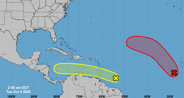
Looking out into the tropics, the wave heading toward the Caribbean is still out there, but the NHC isn’t as enthusiastic about its chances of development.

It is worth watching, but nothing I’d lose sleep over at this time.
DAY TO DAY FORECAST
Today
High clouds and diffuse sunshine. Highs in the mid 80s.
Tonight
Partly cloudy. Lows in the upper 50s.
Wednesday
More high clouds. Highs in the mid 80s.
Wednesday Night
Mostly clear. Lows in the upper 50s.
Thursday
Sunny. Highs in the upper 80s.
Thursday Night
Mostly clear. Lows in the upper 50s.
Friday
Mostly sunny. Highs in the upper 80s.
Friday Night
Partly cloudy. Lows in the upper 50s.
Saturday
Mostly sunny. Highs around 80.
Saturday Night
Partly cloudy in the evening, then becoming mostly clear. Lows in the lower 50s.
Sunday
Sunny. Highs around 80.
Sunday Night
Mostly clear. Lows in the lower 50s.
Columbus Day
Sunny. Highs in the lower 80s.

