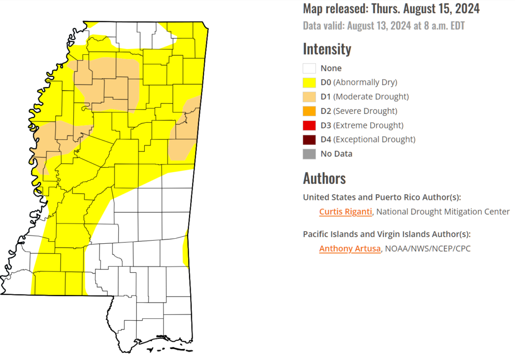
Today through tonight, the primary concern is the continued dry weather and increased fire danger due to a strong subtropical high moving across the Southern Plains and a weakening upper-level trough over the eastern U.S. As we talked about last week, the area is becoming ‘abnormally dry’ in spots and the Drought Monitor reflects that.
This pattern will keep a dry and well-mixed air mass over the area, with only a slight chance for a few showers in far eastern Mississippi. Afternoon humidity levels will drop to near critical levels, and some wind gusts could occur, prompting a concern for wildfires and brush fires.
Looking ahead to Friday and beyond, a little change is expected but high pressure remains in control. The change will be the gradual reintroduction of Gulf Humidity. Although drier air will persist, creating continued fire weather concerns through Friday, a gradual warming trend will be noticeable each day. By next week, heat stress may become an issue with temperatures reaching the upper 90s, potentially requiring excessive heat warnings.
The shot for any rain will remain low, with only isolated showers or brief storms expected this weekend. There is a slight possibility of increased rain by mid to late week as that little system we talked about earlier this week ends up in the Gulf of Mexico — though confidence in its impact remains low. With hurricane season at its peak, any potential developments will be closely monitored.
REGIONAL DAY TO DAY FORECAST
Today: Sunny. A slight chance of showers and thunderstorms this afternoon. Highs in the mid 90s. Northeast winds around 5 mph. Chance of rain 20 percent.
Tonight: Mostly clear. A slight chance of showers and thunderstorms in the evening. Lows around 70. East winds around 5 mph. Chance of rain 20 percent.
Friday: Sunny. A slight chance of showers and thunderstorms in the afternoon. Highs in the lower 90s. East winds 5 to 10 mph. Chance of rain 20 percent.
Friday Night: Mostly clear. Lows in the upper 60s. East winds around 5 mph.
Saturday: Sunny. A slight chance of showers and thunderstorms in the afternoon. Highs in the lower 90s. East winds 5 to 10 mph. Chance of rain 20 percent.
Saturday Night: Mostly clear. A slight chance of showers and thunderstorms in the evening. Lows around 70. Chance of rain 20 percent.
Sunday: Sunny. A slight chance of showers and thunderstorms in the morning, then a chance of showers and thunderstorms in the afternoon. Highs in the mid 90s. Chance of rain 40 percent.
Sunday Night: Mostly clear. Lows in the lower 70s.
Monday: Mostly sunny. A chance of showers and thunderstorms in the afternoon. Highs in the mid 90s. Chance of rain 40 percent.
Monday Night: Partly cloudy in the evening, then clearing. Lows in the lower 70s.
Tuesday: Mostly sunny. A chance of showers and thunderstorms in the afternoon. Highs in the mid 90s. Chance of rain 30 percent.
Tuesday Night: Partly cloudy. Lows in the lower 70s.
Wednesday: Mostly sunny. A chance of showers and thunderstorms in the afternoon. Highs in the mid 90s. Chance of rain 30 percent. Heat index values up to 105.


