We’ve got a stalled boundary that will be lifting back to the north through the evening and during the day tomorrow. This setup will lead to scattered showers and isolated thunderstorms this afternoon, especially along and east of I-55. These showers may linger into the evening before tapering off, although the influx of tropical moisture will continue overnight. Expect temperatures to stay close to seasonal norms.


As we move into Wednesday through Friday, that same boundary / front will hover near or just south of our area, acting as a focal point between the higher dewpoints of the tropical airmass to the south and slightly lower ones to the north which should lead to widespread showers and thunderstorms. Strong upper-level support will increase the coverage of rain, with showers potentially continuing through the night. Rain totals could range from 1 to 3 inches, with some areas seeing even higher amounts. While this rain is much needed to alleviate recent dry conditions, there’s a limited threat of flooding, especially in areas that experience heavy downpours.

Generally, model guidance paints most of the area around 1″ of general rain. Isolated spots will have the chance for higher totals where storms will train over one area or underneath storms that are particularly potent.
Right now, severe weather doesn’t look to be in the cards, but I’ll monitor things and let you know if that changes.
By Friday, the shot for rain will decrease as an upper trough moves into the Great Lakes region, pushing a cold front well southward. This will usher in much drier air, setting the stage for a pleasant weekend.
And perhaps the first taste of near-fall weather. Honestly, it will be great football weather for any games on Friday night.
Looking ahead to Saturday through Monday, expect a noticeable drop in temperatures behind the cold front. This will bring cooler and drier conditions, with some areas potentially struggling to reach 90 degrees!.

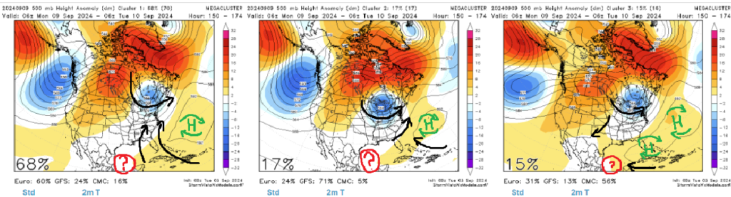
You can see the bombardment of Blue from the north. The maps above show the cooler air descending across the area by “Day 5” which is Saturday..
Next week, we will have to wait and see what happens in the tropics. Recall my post from a few days ago mentioning that it would be this weekend before we knew what may – or may not – happen with the tropical wave in the Atlantic. Model guidance shows it moving intot he Bay of Campeche during the next five days, and then it is uncertain what happens thereafter.

Some model guidance shows it turning northeast and toward Louisiana and Mississippi while other guidance shows it moving into Mexico.
REGIONAL DAY TO DAY FORECAST
Tonight: Mostly cloudy with a chance of showers and thunderstorms in the evening, then partly cloudy with a slight chance of showers and thunderstorms after midnight. Humid with lows in the lower 70s. East winds 5 to 10 mph. Chance of rain 50 percent.
Wednesday: Mostly sunny with a chance of showers and thunderstorms in the morning, then mostly cloudy with showers and thunderstorms likely in the afternoon. Highs in the upper 80s. East winds 10 to 15 mph. Chance of rain 70 percent.
Wednesday Night: Showers and thunderstorms likely in the evening, then showers likely with a chance of thunderstorms after midnight. Lows in the lower 70s. East winds 5 to 10 mph. Chance of rain 70 percent.
Thursday: Showers likely with a chance of thunderstorms in the morning, then showers with thunderstorms likely in the afternoon. Highs around 80. East winds 5 to 10 mph. Chance of rain 80 percent.
Thursday Night: Showers likely. Thunderstorms likely, mainly in the evening. Lows around 70. Chance of rain 70 percent.
Friday: Showers likely. A chance of thunderstorms in the morning, then thunderstorms likely in the afternoon. Highs in the lower 80s. Chance of rain 70 percent.
Friday Night: Mostly cloudy. A chance of showers and thunderstorms, mainly in the evening. Lows in the upper 60s. Chance of rain 50 percent.
Saturday: Mostly sunny with a slight chance of showers. A slight chance of thunderstorms in the afternoon. Highs in the mid 80s. Chance of rain 10 percent.
Saturday Night: Partly cloudy in the evening, then becoming mostly clear. Lows in the lower 60s.
Sunday: Sunny. Highs in the mid 80s.
Sunday Night: Mostly clear. Lows in the lower 60s.
Monday: Sunny. A slight chance of showers in the afternoon. Highs in the upper 80s. Chance of rain 20 percent.
15 DAY FORECAST
The 15 day shows the retreat of the blue on the maps. By the time we get to Day 10, we lose most of the blue and get back to “normal” for this time of year.

And of course, that part of the forecast will be heavily influenced by what happens in the tropics. Holding that aside for the moment, by Day 14 we are right back into the normal-to-slightly-above-normal warmth along and near the Gulf Coast!

Of course, again, that will be dictated by the tropics, too. Which, looking at the model guidance clusters for the Day 6-10 time period, we can estimate that the models are split three ways…
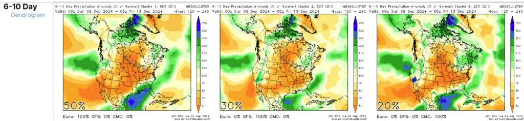
Either the wave moves northeast toward the Southern MS/AL/LA area and dumps rain mainly along the southeast side of the system, nothing happens at all, or the system slides up the Texas coastline.
So we are in wait-and-see mode.


