A quiet start to Friday is expected across the region with increasing cloud cover through the morning. By late afternoon and evening, scattered showers will begin developing as a shortwave trough over Texas slowly moves toward central Mississippi. Temperatures will warm into the upper 70s west of I-55 and low 80s to the east. Rain chances increase tonight, especially in the west, as moisture, strong southerly flow, and instability ramp up. Expect lows in the low to mid-60s.
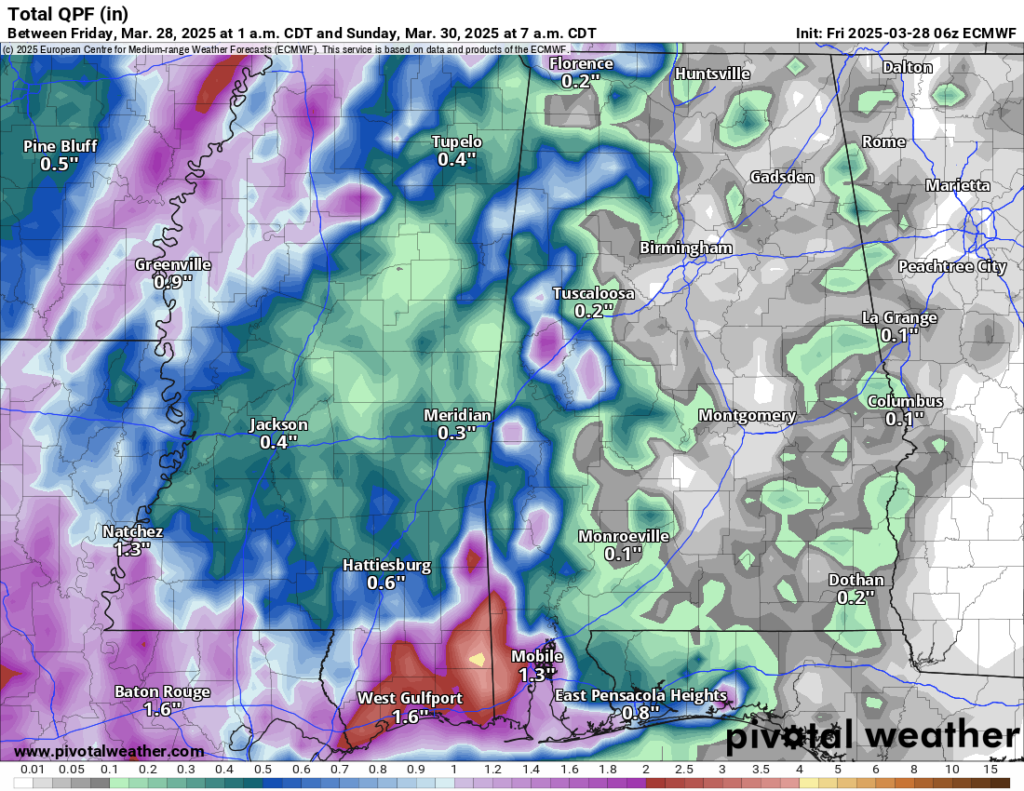
Saturday brings widespread showers and scattered thunderstorms as the system pushes through. While the threat for strong storms remains low, a slight uptick in instability late in the day may support a few stronger storms. Rain will taper off Saturday night, with lingering showers mainly east of I-55.
Again, the severe threat should be pretty low. What this will do is offer a pretty good soaking rain to most of the area.
That changes late Sunday.

I want to stress that it looks like Sunday should be okay during the daylight hours with some isolated showers and storms possible, but widespread stuff shouldn’t develop. But then late Sunday night the next shot for storms arrive. Models are in good agreement that overnight Sunday night and into Monday morning presents the greatest risk for storms and potential severe weather, with damaging winds and hail the main concerns, but tornadoes are also possible.
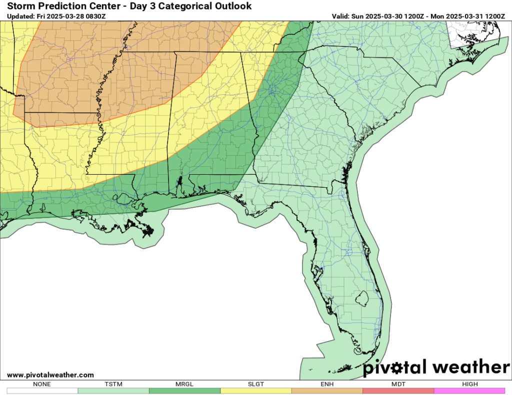
The Storm Prediction Center shows a Marginal or Slight Risk for most of the area, depending on location. The Slight Risk includes areas closer to I-20.
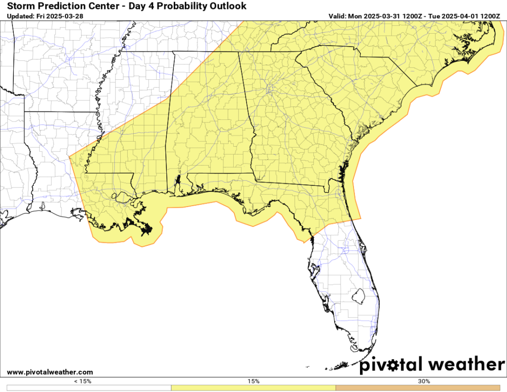
Rain and storms may linger into Monday MID-morning as the front exits, with drier conditions expected by late Monday. After a brief lull Tuesday, another system could bring additional storms midweek. However, forecast confidence is still low due to model differences, so this next potential threat will need to be monitored closely.
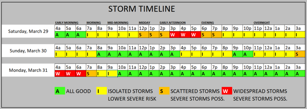
A timeline for the weekend and into next week look slike this:
Looking beyond that, we have a breif dry spell late next week before another round of storms moves through.
REGIONAL DAY-TO-DAY FORECAST
Today: Partly sunny this morning, then becoming mostly cloudy. Highs in the lower 80s. Southeast winds 10 to 15 mph with gusts up to 30 mph.
Tonight: Mostly cloudy. Lows in the lower 60s. Southeast winds 5 to 10 mph with gusts up to 25 mph.
Saturday: Showers likely with a slight chance of thunderstorms in the morning, then showers likely with a chance of thunderstorms in the afternoon. Highs in the mid 70s. Southeast winds 10 to 15 mph with gusts up to 30 mph. Chance of rain 70 percent.
Saturday Night: Cloudy with a chance of showers. A slight chance of thunderstorms in the evening, then a chance of thunderstorms after midnight. Lows in the mid 60s. Southeast winds 10 to 15 mph with gusts up to 25 mph. Chance of rain 50 percent.
Sunday: Mostly cloudy in the morning, then becoming partly sunny. A chance of showers and thunderstorms. Highs in the lower 80s. South winds 10 to 15 mph with gusts up to 25 mph. Chance of rain 50 percent.
Sunday Night: Mostly cloudy. A chance of showers and thunderstorms after midnight. Lows in the upper 60s. Chance of rain 60 percent.
Monday: Storms in the morning, then clearing by afternoon. Highs in the mid 80s. Chance of rain 90 percent.
Monday Night: Partly cloudy. Cooler with lows in the upper 50s.
Tuesday: Mostly sunny. Highs in the lower 80s.
Tuesday Night: Partly cloudy in the evening, then becoming mostly cloudy. Lows in the mid 60s.
Wednesday: Partly sunny. Highs in the mid 80s.
Wednesday Night: Mostly cloudy. A slight chance of showers and thunderstorms after midnight. Lows in the upper 60s. Chance of rain 20 percent.
Thursday: Mostly cloudy in the morning, then becoming partly sunny. A slight chance of showers and thunderstorms. Highs in the mid 80s. Chance of rain 20 percent.
15-DAY OUTLOOK


