2,029 words | 11 minutes read time
There is potential for severe storms across the area as we move through Friday, Saturday, and into Sunday. The Storm Prediction Center (SPC) has placed most of the region under a Moderate Risk, which is a 4 out of 5 on their scale—where 5 represents the highest threat level for significant severe weather.
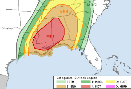
The SPC is particularly concerned about damaging wind gusts over 60 mph, hail larger than quarters, and the possibility of a few tornadoes—including strong tornadoes. I think the top-end threats look like wind up to 75mph, hail up to the size of golf balls and tornadoes up to EF-4 in strength.
Yes, EF-4 tornadoes are possible.
That said, it’s important to put this risk into context and consider different scenarios to give you a full picture of what could happen.
First, let me be clear: There will be storms. We’re not getting through this with sunny skies and everyone staying dry. Nearly everyone has a chance of seeing at least a strong storm—not necessarily severe, but the kind that makes you look out the window and think, “Wow, that’s some rough weather.”
How this unfolds will depend on how the atmosphere sets up. We could see a long line of storms sweeping through, or a few scattered storms popping up here and there.
Now, I know some of you may be reading this thinking, “Well, which one is it?! Not much of a weatherman if you’re just waffling back and forth—make a decision!”
But that’s not how meteorology works. That’s not what we do. And that’s never been how I approach forecasting. Instead of making an ironclad prediction more than 48 hours out, I’d rather give you the knowledge and tools to be prepared—no matter which outcome plays out.
Because in the end, it’s not about betting on one scenario. It’s about making sure you’re ready for all of them.
THE SETUP
We have a potent system set to deepen across the Midwest and Northern Plains. I don’t think it’ll go full “bomb cyclone” on us, but it will undergo significant strengthening as it moves northeast.
At the same time, lee cyclogenesis will kick off across the foothills of the Rockies, helping to push a dryline eastward across Texas. Then, a trailing shortwave trough, accompanied by a cold front, will dive south—setting the stage for showers and storms in our region.

What complicates the forecast?
Any shift in the timing or trajectory of these three key features will change how things play out. Right now, model guidance is lining up nearly “perfectly” for severe weather to occur.
That brings me to an important point: If we do see changes in the models, the more likely outcome is for those changes to reduce the severe threat rather than increase it.
Could we see an unexpected shift that ramps up the risk for more significant severe weather? Sure. But statistically speaking, it’s far more likely that any major change in model guidance would diminish the threat rather than make it worse.
FAILURE MODES
Scenario 1: The Main Low Moves Northward More
If the main low shifts farther north, one key change would be a weaker dryline in Texas. A less potent dryline means fewer storms firing up on Friday across East Texas, Oklahoma, Louisiana, and Arkansas—which, in turn, would lower the severe weather risk for our area on Friday.
But Nick, our storms are on Saturday!
Yes, our highest risk is Saturday, but this kind of shift would mean fewer storms Friday night as well—maybe just one or two rather than a broader outbreak.
A weaker Friday setup also means we’d lose the outflow boundaries from earlier storms. These localized air masses often serve as interaction points, helping storms intensify or aiding tornado development. Without them, we’d have to rely on the cold front or hope that an updraft can break through the cap of warm air to initiate storms—both possible, but less likely.
If this scenario plays out, we would need to wait for the warm front to push through on Saturday morning for the next round of storms. These would likely be isolated. Then, as the cold front arrives Saturday afternoon, it would bring a line of storms with embedded supercells.
Could storms develop in the open warm sector between the warm front and cold front? Possibly, but a semi-stout cap of warm air aloft might suppress surface-based updrafts.
In this case, we’d still see plenty of rain, wind, and lightning, but the risk for large hail and widespread tornadoes would be lower. Instead of a large outbreak, we might see just a few tornadoes, and for any to be strong, specific conditions would have to come together just right.
Scenario 2: The Dryline Fires Off an MCS in East Texas on Friday
Most models aren’t showing this, but I do wonder if this system could fire off a few storms that congeal into a mesoscale convective system (MCS). If that happens, it could ride the instability through Louisiana, Arkansas, and Mississippi on Friday afternoon and evening.
This would be both good and bad:
- Good:
- It would consume some of the available atmospheric energy, reducing instability.
- It would drop a cold pool of air along its path.
- If the MCS becomes large and long-lived, it could cut off the surge of warm, moist Gulf air, reducing Saturday’s severe threat in its wake north of I-20. It would also slow down the northward movement of the warm front, limiting instability further, too
- If storms fire early enough – before full daytime heating – they could “sour the milk” of the atmosphere, making it tougher for any individual storm to become dominant and well-organized.
- Bad:
- South of the MCS, warm air and moisture would still be in place.
- Numerous outflow boundaries could provide a catalyst for storms on Saturday, aiding tornado development and rotation.
The key factor here is that the cap of warm air Saturday morning doesn’t look particularly strong. So if we get even a small atmospheric push, storms shouldn’t struggle to develop.
Scenario 3: The Surface Low Fails to Develop, and the Front Weakens
If the surface low doesn’t fully develop and the trailing cold front weakens and fails to push far enough south, then this system won’t have the same punch.
What does that mean?
This wouldn’t be a widespread event. We would start to talk about potency, not ubiquity. And, to put it bluntly, it might feel like a bust-o-rama for those expecting a widespread, severe weather outbreak, with tornadoes all over the place. If the cold front doesn’t tilt more meridionally, storms may struggle to form south of I-20.
That said, “storms may struggle” doesn’t mean “no storms will happen” as I think a few storms will still develop. And, in an environment like this, it wouldn’t take much for those isolated storms to reach severe levels.
This scenario would not produce the “knock-down, drag-out” severe weather day that some models—and social media—are hyping up. But the storms that do form could still be intense.
Regardless of Specifics
The exact evolution of this system remains fluid, but we’re dealing with a setup where small changes in timing, positioning, and strength will dictate how things play out.
For now, model guidance continues to favor a setup that supports severe storms, but if that changes, the most likely outcome is a lower threat, not a higher one.
As always, I’ll keep watching things and provide updates as the picture becomes clearer!
THE DATA
When looking at the overall setup, I think there’s good reason to question the likelihood of multiple storms producing multiple strong tornadoes (EF2 or stronger) in our area.
- North of I-20? The likelihood increases.
- East of I-65? We get into even better parameter space.
But for us? I think we may see two, maybe three strong tornadoes—but I’d be hard-pressed to look at the data and suggest more than that.
One important caveat: Given this setup, there’s potential for long-track supercells. That means a single storm could become rooted, organized, and then march across our area for miles. If it produces a tornado that touches down intermittently 15 times over 15 miles, each touchdown could technically count as a “strong tornado.” But in reality, it’s the same storm, producing the same tornado, repeatedly cycling.
Now, let’s look at the Karrie Meter maps (finally have them back!). They show a broad area of values between a 4 and a 6, which translates to a Slight Risk or Enhanced Risk from the SPC, a “2” and “3” on their 1-to-5 scale.

This suggests the Karrie Meter is less impressed with this event compared to past severe setups. For example, the Easter 2020 event from the same model was an “9” at the highest point.
Interestingly, this model has historically struggled with high CAPE days, often over-predicting severe weather. But in this high CAPE setup, it’s actually returning lower values. That’s something to watch. Looking across all model guidance, and trying to find a singular number the Karrie Meter is a bit higher.
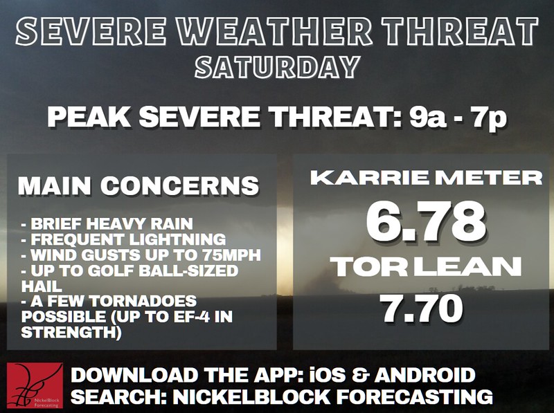
That “Tor Lean” part showing higher than the Karrie Meter number itself means that tornadoes – in this situation – are more likely that climatological average for this kind of an event. But that doesn’t indicate the -number- of tornadoes will be higher, just that the environment is more favorable. And it takes more than a favorable environment to produce a tornado.
Looking beyond the Karrie Meter, model guidance as a whole presents a wide spread in potential impacts. That said, most models have settled on a robust day for severe weather.
The Convection-Allowing Models (CAMs) all favor supercells as the dominant storm mode for our area, supported by:
- Strong lapse rates
- High instability (CAPE)
- Shear and helicity
- Long, arching hodographs
As I mentioned from the start, most models continue to paint a “perfect” environment for storms to develop.
But as they said in Monty Python: Search for the Holy Grail…

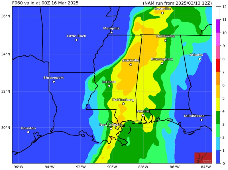
THE TIMELINE
Here is a look at the timeline for storms centered on the I-59 corridor. If you live to the west move this timeline earlier by a few hours and if you live to the east, move it later by a few hours.

This timeline is not set in stone, either. If anything, I feel like things may speed up a bit, rather than slow down. But we still need to wait another 24 (perhaps even 36 hours) before things may settle in. And by then, storms may actually be developing.
THE BOTTOM LINE
Storms will happen on Saturday—that’s the only guarantee at this point. Some will be severe, bringing heavy rain, frequent lightning, wind gusts up to 70 mph, hail up to the size of a golf ball, and the potential for a strong tornado. That means some of these storms could be rather potent, so take time today—or even right now—to prepare.
Know where your safe place is and have a plan for what you would do if a warning is issued. Keep a storm kit in your safe place with water, non-perishable food, a flashlight, a whistle, and a helmet. It’s also a good idea to keep a pair of sturdy shoes there in case you need to move around safely after the storm. Stay updated on the forecast over the next 48 hours so you’re not caught off guard by any shifts in timing or severity.
I know severe weather can feel overwhelming, but remember that knowledge is power. Being aware of the risks and having a plan in place helps reduce uncertainty and fear. It’s also important to keep in mind that while forecasts will continue to evolve, a shift in the models is more likely to lower the severe threat than increase it.
So while preparation is key, we don’t need to assume the worst-case scenario. At the end of the day, we will get through this. Understanding the risks, having a plan, and staying informed will give you the confidence to navigate whatever comes our way.


You my friend are a realist and that is refreshing. It seems so many want to be an Al Roker, terrorizing that 100 millon viewers in the storms path. LOL Thanks for your infomative insights.
Thank you, Nick for looking out for us, again! There IS one bright spot in all this … hopefully, it’ll put a big dent in the pollen.