I will say, it’s not a drastic change in temperature for the week, but it will feel much drier and windier for the next several days as the cold front moves in tomorrow. Much of us in southern MS/LA/AL won’t see the effects until later in the day on Monday, however the wind will be felt through much of the day as it shifts northward.
This evening we’ll have a few stray showers from east to south Mississippi and eastern Louisiana moving southeast.
Early to Mid-week
Starting off the week is the “summer-buster” cold front we’ve all been waiting for the past month. Temperatures won’t take a nosedive, but it will be more noticeable in terms of humidity. The dew point will drop into the 50s and flux between the 40s and 50s for the next few days which will be a nice departure from the mid-60s we’ve had this past weekend.
The winds will shift towards the north indicating the dry weather, however fire weather will also be a concern with gusty winds possible throughout until around Thursday. Temperatures will reduce a bit from the upper 80s tomorrow to the mid and low 80s for the rest of the week. Overnight, the temperatures will drop into the mid to upper 50s for much of the inland parts of the Deep South.
The Rest of the Week and the Weekend
Starting Thursday, a low from the Great Lakes region will move south towards our neck of the woods. This will inhibit any rain chances we have for another few days, but it will also cut back on the fire weather. Winds will be at a steady 5 to 10 and eventually will calm as the high moves further south. This won’t affect temperatures much, but we will have a slight spike in humidity on Thursday and Friday before falling back into the 40s and 50s again. Saturday will be a similar story with temperatures in the mid 80s during the day and the mid 50s overnight.
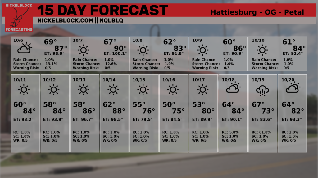
Here’s the 15 day forecast:
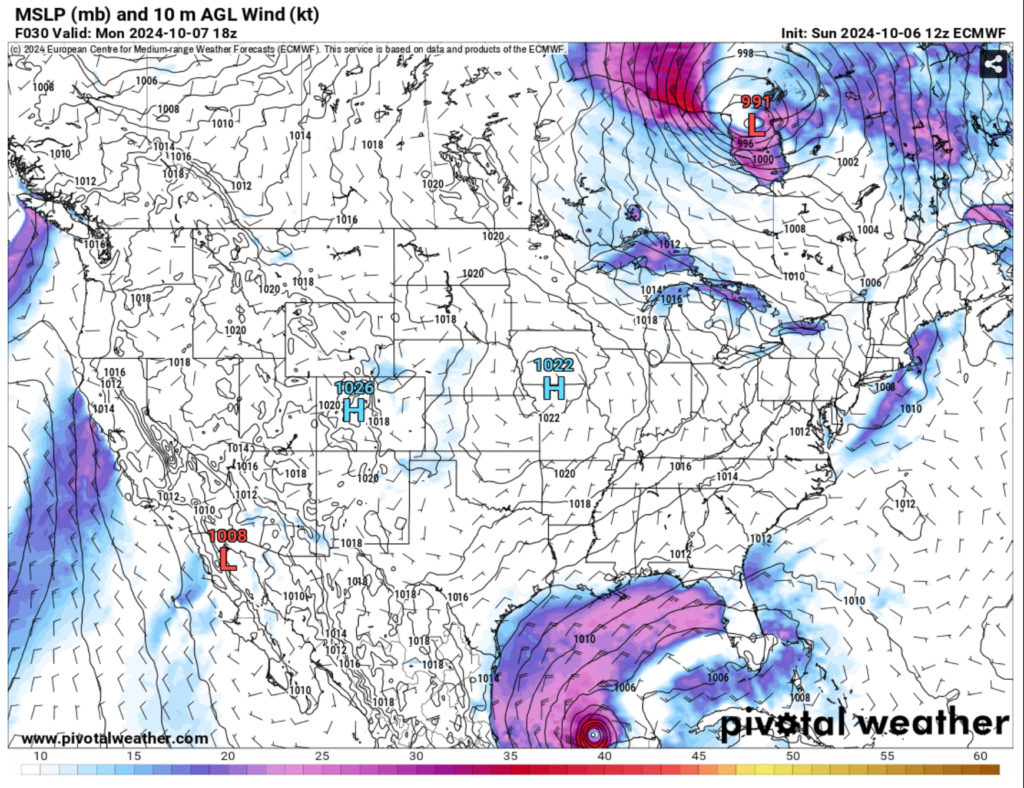
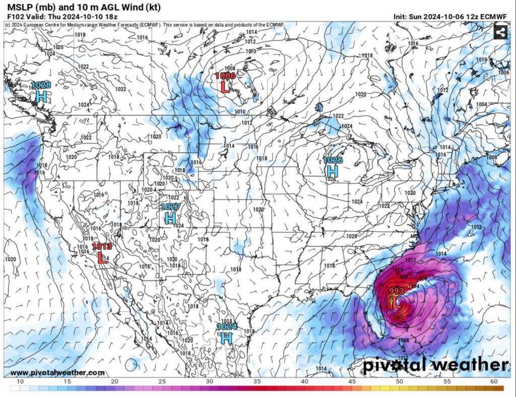
Hurricane Milton
So a lot changed since my post yesterday. I did notice the GFS had Milton more correct in terms of strength, however what the National Hurricane Center saw was much more intense, and that may have been with further model updates. But if you’ve seen the news on social media in the past 24 hours, the NHC has forecasted Milton to be a major hurricane fast before it reaches inland, and for good reason.
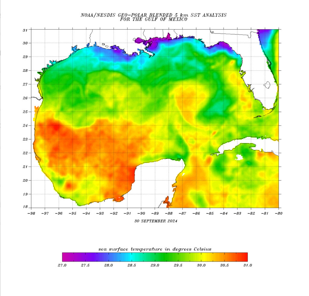
The Sea Surface Temperatures I mentioned yesterday are a definite for Milton’s development starting in the Yucatán and as it moves eastward. It will see a slight dip around the horn of the Yucatán but then have a whole channel of warm water to work with as it moves into the center of the Gulf of Mexico. Needless to say, it’ll have plenty to work with before it moves inland.
It’s movement towards Florida is due to the cold front we’ll see in the Deep South mixed with mid-level northerly flow keeping it towards the southern Gulf. Guided by these and the warm water in the middle of the Gulf and it’s heading eastward towards Florida.
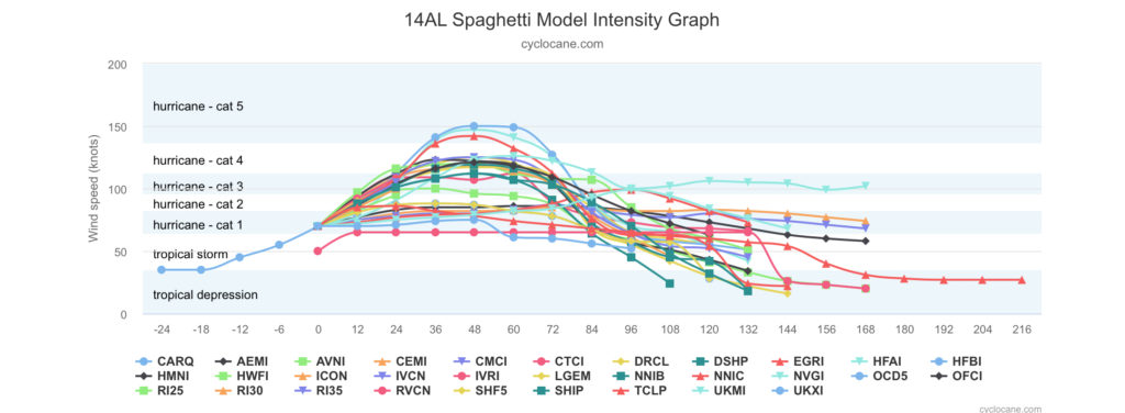
Spaghetti plots show Milton strengthening on average to a strong Category 3 to a possible Category 4 at its strongest. Most of the location plots put it south of Big Bend towards the Tampa Bay area. The timing looks to be around Wednesday, and this is a fairly decent moving storm coming in within a couple of days. For anyone in the southern Florida area from Tampa to Orlando and the Atlantic Coast need to be prepared as it moves across the state.
Regional Day-to-Day Forecast
This Afternoon – A 20 percent chance of showers. Sunny, with a high in the mid 80s. Northeast wind around 10 mph.
Tonight – Mostly clear, with a low in the mid 60s. Northeast wind around 5 mph becoming calm in the evening.
Monday – Sunny, with a high near 90. North northeast wind 5 to 10 mph, with gusts as high as 20 mph.
Monday Night – Clear, with a low around 60. North wind around 5 mph.
Tuesday – Sunny, with a high in the mid 80s. North wind 5 to 10 mph.
Tuesday Night – Clear, with a low in the upper 50s. North wind around 5 mph.
Wednesday – Sunny, with a high in the mid 80s. North northeast wind 5 to 10 mph.
Wednesday Night – Clear, with a low in the upper 50s. North wind around 5 mph.
Thursday – Sunny, with a high in the mid 80s. North northeast wind 5 to 10 mph.
Thursday Night – Clear, with a low in the upper 50s.
Friday – Sunny, with a high in the mid 80s.
Friday Night – Clear, with a low in the mid 50s.
Saturday – Sunny, with a high in the mid 80s.
Saturday Night – Clear, with a low in the mid 50s.
Sunday – Sunny, with a high in the mid 80s.


One thought on “The “Summer-buster” is Coming – Weekly/Tropical Outlook for 10/6/24”
Comments are closed.