While the SPC is highlighting the region with the potential for severe weather, it isn’t a total slam dunk at this time. I know everyone and their brother with an interest in the weather is quick to tell you why severe weather is likely and why a giant tornado will occur. And sure, in the coming days things may shake out that it ends up being very certain that severe weather will occur for some folks. But for everyone? Not as likely.
So I want to take an opposite approach.
I hear from a lot of folks with these kinds of situations asking, “is there anything that can make it go away?” and the short answer is, “not really” but the longer answer is, “yes, it could.” So, here is a look at a few things that may limit the overall potential for severe weather for everyone. These aren’t guaranteed to happen, ether. But if you’re hoping for something, hope for these things to happen.
Too much shear – Likelihood: 20% chance
To get severe weather in the Spring often times you need a few things in the atmosphere: Instability and Shear are the two biggies. But you can’t have too much of one and not enough of the other, or else you won’t get severe weather.
In the case of Tuesday, there may be too much shear.
Shear, recall, is the changing of wind speed and direction as you move up in altitude in the atmosphere. This very artistic representation below shows that the updraft (red arrow) into the cloud is acted upon by the shear (blue arrows) at different directions and speeds.

At times, the shear can be so strong that it can, in essence, decapitate the updraft. It cuts the updraft off and a given height (sometimes at 10,000ft, other times at 20,000ft) and stops storms from growing to be as deep.
Tuesday shows a chance that over-shearing may occur. The data from the NAM model earlier today shows an atmosphere with 55kts to 70kts of directional shear between 900mb and 500mb.
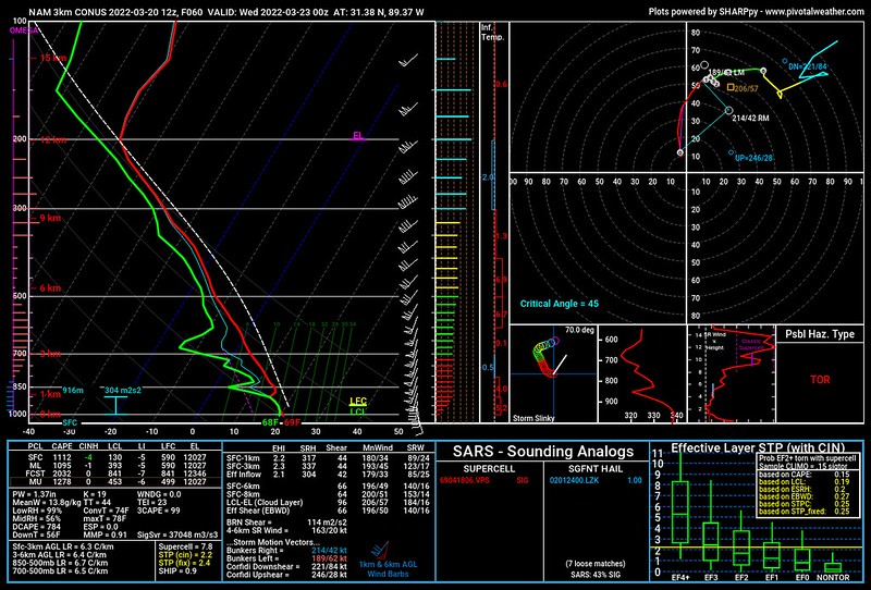
In English? Well, updraft speed can be calculated by taking the square root of double the CAPE value. And the CAPE value is about 1100. So the square root of 2200. That is about 45. And the units are meters per second. So we just convert that to knots per hour and you get about 85kts/hr
Well, if the horizontal wind speeds are between 55kts and 70kts per hour, then any pocket of air that wants to move upward is going to get strung out pretty quickly. And that may limit the ability for storms to grow to have deep convection because updrafts will be too tilted.
Blob off the coast – Likelihood: 5% chance
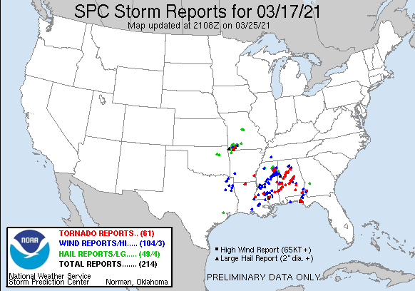
There have been a handful of sever weather events over the past decade along the Gulf Coast that have never produced a single severe storm due to a phenomenon I dubbed “the blob” back in 2014.

The blob is a cluster of storms that form ahead of the cold front and squall line down along the coast or out into the Gulf that suck up all of the low-level heat and moisture trying to flow into the region from the Gulf of Mexico.
The image above is the European model for Tuesday evening showing a pronounced blob along the coast. This would limit the threat for severe weather and tornadoes to the north.
It is worth noting, though, that while The Blob is possible. It doesn’t often actually come to our rescue.
In fact! Almost one year ago we were looking at a similar setup with a Day 4 Enhanced Risk (now Day 3 Moderate) and forecast data showing the chance at a Blob. It never ended up ‘blobbing’ so we had a day of relatively significant severe weather.
You can read about it here, if you’d like.
The same thing happened in February of 2020, too. We were tracking the chance for a blob, and no blobbing ever happened. And it was another day of significant severe weather.
Contaminated pre-frontal environment – Likelihood: 3% chance
There are times the warm sector ahead of a cold front is “uncapped” and all of th showers and storms go up at once ahead of the front. This happens frequently during the cool season along the Gulf Coast and then later in the Spring, too.
Warm air off the Gulf spreads across the region, we get some daytime heating and BOOM! storms go up all over the place.
These storms can turn severe, but most times these storms end up clustering together and it really limits how potent they can become and really, really limits the tornado threat.
In order for that to happen, often we need an environment ahead of the front that is, as I said above, ‘uncapped’ and free to form showers and storms. This happens where there is surface-based instability without much forcing. Think of it like a hot August day along the Gulf Coast. Big poofy clouds everywhere. And a few storms here and there with heavy rain and gusty wind, but not many tornadoes.
Same idea applies.
IF this were the case on Tuesday it may also look a bit like the European model image from above. Clusters of storms all over the place like that limiting the threat for discrete supercells. Because in order to get the big bad tornadoes, you need supercells. And there are really only two ways to do that – when they are out there by themselves with no other storms around or embedded within a line squall line along a front.
But if things cluster up, wave goodbye to the strong tornado threat.
Sadly, in this case, this looks like the least likely scenario. Because a lot of the forecast data does, in fact, show some capping aloft ahead of the main line of storms.
This means if – big if – storms develop ahead of the line, it will be in places where an updraft was able to get rooted and it will be able to tape into all of the other parameters necessary to make a severe storm.
The reality
Even if we add up the chance that all of these things actually occur, you still only get to 28-percent. That leaves a 72-percent chance – even if we added all those things up! – that severe weather occurs somewhere. And the SPC is showing the Risk as high as a 45-percent chance that within 50 miles of a point a severe storms occurs in parts of Louisiana and Mississippi. That is roughly 20-times higher than historical average.
So, while yeah, I’m telling you there is a chance we get through this without any severe weather, the chance isn’t very high at all.
But if you want something to hope for… hope for one – or all – of those things to happen.


One thought on “Tuesday’s severe threat isn’t a slam dunk, if you don’t want severe weather, hope for one of these things…”
Comments are closed.