Welcome to the 2022 Hurricane Season. And right on cue, there are two areas to watch.

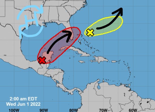
The leftovers of Agatha is mixing it up with the Central American Gyre over the Yucatan and there is a second area northeast of the Bahamas that may try to swirl up into a system, too.
From the NHC:
Near the Yucatan Peninsula and Southeastern Gulf of Mexico:
A large area of disorganized showers and thunderstorms located over the northwestern Caribbean Sea and Yucatan Peninsula is associated with a broad area of low pressure. Environmental conditions appear conducive for gradual development, and this system is likely to become a tropical depression while it moves northeastward over the northwestern Caribbean Sea and southeastern Gulf of Mexico during the next couple of days. Regardless of development, locally heavy rainfall is likely across portions of southeastern Mexico, the Yucatan Peninsula, and Belize during the next day or so, spreading across western Cuba, South Florida, and the Florida Keys on Friday and Saturday. Interests in the Yucatan Peninsula, western Cuba, the Florida Keys, and the Florida Peninsula should monitor the progress of this system.
— Formation chance through 48 hours…high…70 percent.
— Formation chance through 5 days…high…80 percent.
Southwestern Atlantic northeast of the Bahamas:
A weak surface trough located around 200 miles northeast of the central Bahamas is producing disorganized shower activity as it interacts with an upper-level trough. Surface pressures are currently high across the area, and significant development of this system appears unlikely as it moves generally east-northeastward over the next several days away from the southeastern United States.
— Formation chance through 48 hours…low…10 percent
— Formation chance through 5 days…low…10 percent.
More importantly, around here, there is a chance for storms here and there as we head through the next few days. These will all be summertime storms, mainly confined to the afternoon and won'[t last much longer than an hour at a time.
Thursday and Friday look to offer the best bet for storms. There might be a front that tries to back through the region. The cold front won’t make it far enough south to cool things down, but it will offer the chance to fire up storms that eventually push through the area later in the evening and overnight.
Then things dry out for the weekend.
Day to Day Forecast
Today
Mostly sunny with a few storms possible. Highs in the lower 90s. Chance of rain 20 percent.
Tonight
Mostly clear. Lows in the upper 60s. Southwest winds around 5 mph.
Thursday
Mostly sunny with a few storms possible. Highs in the lower 90s. Chance of rain 20 percent.
Thursday Night
Mostly cloudy with a chance for storms overnight. Lows in the upper 60s.
Friday
Mostly sunny with a 40-percent chance for storms. Highs in the upper 80s.
Friday Night
Partly cloudy. Lows in the upper 60s.
Saturday
Sunny. Highs in the lower 90s.
Saturday Night
Mostly clear. Lows in the upper 60s.
Sunday
Sunny. Highs in the mid 90s.
Sunday Night
Partly cloudy. Lows in the upper 60s.
Monday
Mostly sunny with a few storms possible. Highs in the lower 90s. Chance of rain 20 percent.
Monday Night
Mostly clear. Lows in the lower 70s.
Tuesday
Mostly sunny with a few storms possible. Highs in the mid 90s. Chance of rain 20 percent.


I live in south MS, about 90 miles from the coast. Which area is of more concern this hurricane season, the GOM and Caribbean, or the ones coming off the African coast?
I’d focus closer to home, Charles, and look into the Gulf. I think many of the waves off Africa will get turned north before they make it to the Gulf and many of the Caribbean storms will either go west or curl east. But the ones that form near the Gulf will be the ones to watch the most.