A surface ridge extends over the northern Gulf, and a cold front stretches from north of Columbus to south of Greenville. Satellite imagery shows stratus clouds moving into the region, which may cause areas of dense fog.
We may see a few light showers here and there north of I-20, but overall, dry weather is expected through tonight and tomorrow. Afternoon temperatures will be cooler than Thursday but still above normal, with lows around the lower 60s. Stratus and fog may return by sunrise.
The forecast shows a wet weather pattern as a cold front pushes into northern areas and stalls. Onshore flow and weak disturbances will bring moderate rainfall, with some localized heavy amounts possible. Seasonal temperatures are expected north of the front, while warmer conditions may continue in the southeastern areas.
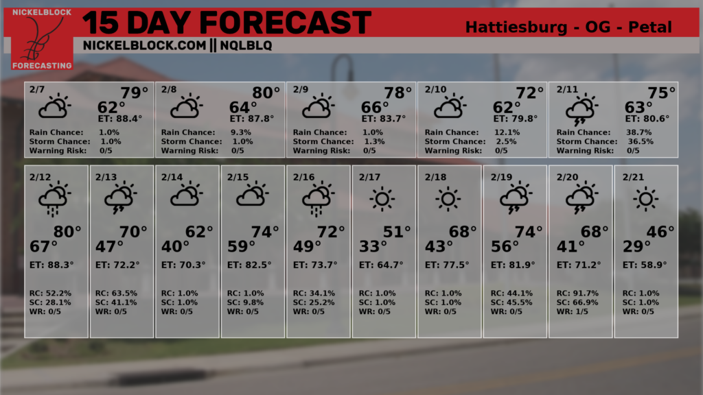
Then, as we move through the middle of next week, we will see a shot for storms as a parade of systems push through the area. The CIPS Analogs from Saint Louis University are showing a pretty decent shot (historically speaking) that this kind of setup produces severe weather.
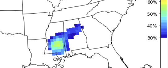
And, looking at the model guidance, we may actually end up with two rounds of severe weather during this time period. We may get one round roll through around the 12th and then again on the 15th. Which may mean the map above is clumping two potential rounds into one, which would then show up on that map as a higher risk than there actually is.
Either way, it does look like that window of time will offer a chance for storms and the potential for severe weather.
Even NQLBOT, our aI Weather Helper, shows that risk. The Bot also shows a chance for some cooler temperatures to roll in around the 21st.
REGIONAL DAY TO DAY FORECAST
Today: Mostly cloudy this morning, then becoming mostly sunny. Areas of dense fog this morning. Highs around 80. Southwest winds 5 to 10 mph.
Tonight: Partly cloudy in the evening, then becoming mostly cloudy. Areas of fog after midnight. Lows in the mid 60s. South winds around 5 mph.
Saturday: Mostly cloudy in the morning, then mostly sunny with a slight chance of showers in the afternoon. Highs in the upper 70s. South winds 10 to 15 mph. Chance of rain 20 percent.
Saturday Night: Partly cloudy in the evening, then becoming mostly cloudy. Patchy fog after midnight. Lows in the lower 60s. Southwest winds 5 to 10 mph.
Sunday: Areas of fog in the morning. Mostly sunny. Highs around 80. Southwest winds around 5 mph.
Sunday Night: Partly cloudy in the evening, then becoming mostly cloudy. Lows in the upper 50s.
Monday: Mostly cloudy in the morning, then mostly sunny with a slight chance of showers in the afternoon. Highs in the upper 70s. Chance of rain 20 percent.
Monday Night: Mostly cloudy with a 20 percent chance of showers. Lows in the upper 50s.
Tuesday: Mostly cloudy in the morning, then becoming partly sunny. A chance of showers. A slight chance of thunderstorms in the afternoon. Highs in the upper 70s. Chance of rain 30 percent.
Tuesday Night: Mostly cloudy. Showers likely with a slight chance of thunderstorms in the evening, then a chance of showers and thunderstorms after midnight. Lows in the upper 50s. Chance of rain 40 percent.
Wednesday: Mostly cloudy in the morning, then becoming partly sunny. A slight chance of thunderstorms in the morning. A chance of showers. Highs in the mid 70s. Chance of rain 40 percent.
Wednesday Night: Mostly cloudy. A chance of showers with a slight chance of thunderstorms in the evening, then showers likely after midnight. Lows in the lower 60s. Chance of rain 40 percent.
Thursday: Partly sunny with a chance of showers with a slight chance of thunderstorms. Highs in the lower 70s. Chance of rain 30 percent.


