High pressure in the area will start to drift east. It means an increase in everything Summer-related. The heat is returning, as is the humidity. We will also start to see more clouds and a few more spotty showers and storms starting on Thursday. And then even more as we move through the weekend and into next week.
In fact, today we will already be back to it feeling like 100F if you’re working outside in the sunshine.

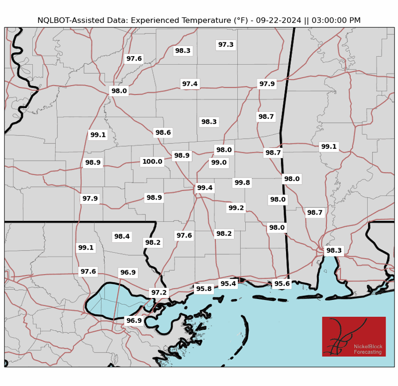
By Saturday, the Experienced Temperatures will be back to around 110F. Really hot stuff.
The combination of high temperatures and rising humidity could lead to heat stress, so it’s important to stay hydrated and avoid strenuous outdoor activities during the hottest parts of the day. A Heat Advisory might be issued if conditions warrant it, so keep an eye on future forecasts for updates.
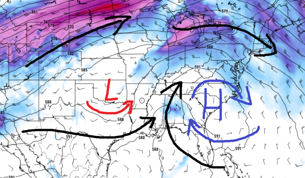
Starting Sunday things change a bit. The map above highlights it pretty well, we will reorient the atmosphere to open up a corridor for tropical moisture to sturge northward. This plume of moisture from the Gulf of Mexico will bring better chances for rain and storms. And the outside shot for some brief localized flooding, as it appears that the storms that do develop will be very proficient rain producers.
So far it doesn’t look like anything will be terribly organized, but we will continue to monitor trends. .
REGIONAL DAY TO DAY FORECAST
Today: Mostly sunny. Highs in the lower 90s. North winds around 5 mph.
Tonight: Mostly clear. Lows in the upper 60s. Northwest winds around 5 mph in the evening, becoming light and variable.
Thursday: Sunny. Highs in the mid 90s. Northeast winds around 5 mph.
Thursday Night: Mostly clear. Lows around 70. South winds around 5 mph in the evening, becoming light and variable.
Friday: Sunny with a few passing clouds. Highs in the upper 90s. Northeast winds around 5 mph. Chance for rain around 10 percent.
Friday Night: Mostly clear. Lows in the lower 70s.
Saturday: Sunny with passing clouds and a few isolated storms possible. Highs in the upper 90s. Heat index values up to 105. Chance for rain around 20 percent.
Saturday Night: Mostly clear. Lows in the lower 70s.
Sunday: Mostly sunny with a chance of showers and thunderstorms. Highs in the lower 90s. Chance of rain 40 percent. Heat index values up to 105.
Sunday Night: Mostly cloudy with a chance of showers and thunderstorms. Lows in the lower 70s. Chance of rain 30 percent.
Monday: Mostly cloudy. A chance of showers and thunderstorms in the morning, then showers and thunderstorms likely in the afternoon. Highs in the mid 80s. Chance of rain 60 percent.
Monday Night: Mostly cloudy with a chance of showers and thunderstorms. Lows in the mid 70s. Chance of rain 30 percent.
Tuesday: Mostly cloudy. A chance of showers and thunderstorms in the morning, then showers and thunderstorms likely in the afternoon. Highs in the upper 80s. Chance of rain 40 percent.


