Hurricane Sandy, often referred to as ‘Superstorm Sandy’, defied the hurricane norms with its unusual path, vast size, and devastating effects on the northeast U.S. Why was this storm, which transitioned from a Category 1 system to an extratropical cyclone before landfall, one of the more impactful storms on record? Using Sandy’s extratropical transition and other interfering upper-level occurrences, I hope to bring more awareness to the potential for other storms like Sandy.
Some factors I will be looking at include specific atmospheric conditions, such as the jet stream and mid-level troughs, as well as a process called extratropical transitioning. The goal is to investigate these topics and further understand why Sandy was a unique occurrence and why it experienced rapid intensification right before making landfall in the U.S.
BACKGROUND:
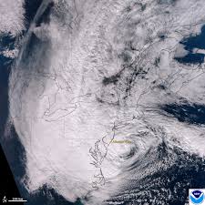
Hurricane Sandy first developed in the Caribbean Sea, reaching Category 3 status before making landfall over Cuba and the Bahamas. As Sandy shifted and moved northeast, it continued to strengthen before making a westward shift towards the northeast United States, which started Sandy’s weakening. However, not long before making landfall again over New Jersey, Sandy transitioned to an extratropical system. The system made its way well into the region with plenty of rain and wind for the next couple of days as it fully dispersed.
While it was very well forecasted, it still left a lasting impact on the region. It was given the nickname “Superstorm Sandy” due to the record-breaking storm surge amounts and flooding that caused majority of the damage experienced in the region. Hurricane Sandy is one of the costliest storms in our history, causing over $50 billion in damages, claiming 147 lives overall, and impacting 24 states in the U.S.
Storms of this degree are uncommon for the Northeast, so many believe that Sandy was a wakeup call for the northeast and its hurricane preparedness. It’s very important to note that Sandy was not a hurricane at the time of landfall, which makes it unique compared to ‘typical’ hurricanes. This is because of the complex transition from tropical cyclone to extratropical system.
After getting the background information, why should we care about Hurricane Sandy and its impact? The reason is so we as meteorologists have a better understanding of circumstances like Sandy, along with giving information out so areas can be better prepared for situations like Sandy.
WHAT MADE SANDY UNIQUE?
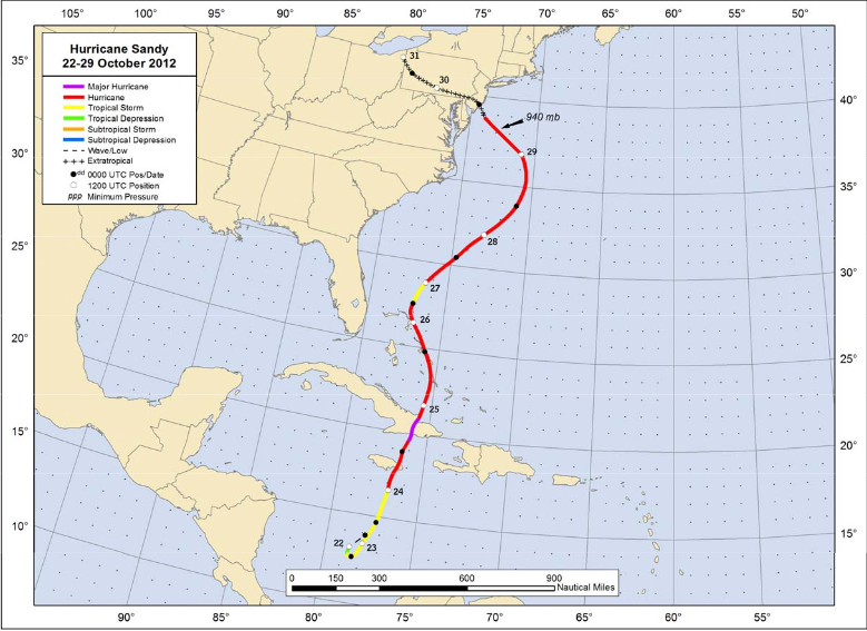
Hurricane Sandy first developed on October 22nd, 2012, which is very late into hurricane season and less common. Sea surface temperatures were unusually warm which supplied energy for Sandy to intensify quickly. Sandy’s size at the start of formation and throughout its lifespan was notable large, which allowed it to strengthen and grow as it continued north. Some other factors that influenced Sandy’s development include high amounts of moisture in the troposphere, low amounts of wind shear, and existing tropical waves/disturbances that jumpstarted development.
As we know, Sandy ended up shifting to head straight for the northeast U.S. This shift was caused by several influences. One being a blocking high-pressure system that was located over Greenland. This high was associated with the North Atlantic Oscillation negative phase and forced Sandy away from the typical hurricane route. Other factors like a mid-latitude trough that helped pull Sandy to the northwest and the jet stream position that helped deepen said trough.

The last and most interesting milestone Sandy reached was the transition from hurricane to an extratropical storm. An extratropical transition is a process where a warm core, nonfrontal storm shifts to a cold core, frontal system. This transition started on October 29th before making landfall in New Jersey. Most researchers agree that his transition helped to give Sandy and extra boost of strength as well as its odd path trajectory.
Studies believe that this intensification occurred due to the merging of the tropical system with the mid-latitude trough in the northeast US. As a result of the transition, Sandy became a baroclinic system rather than a tropical system. Baroclinic systems differ from tropical systems because they have frontal boundaries and a cold core while tropical systems are the opposite. The transition allowed for these baroclinic feature to form, which helped to expand the wind field of the system.
WHAT WAS DISCOVERED?
Multiple articles have taken on the topic of Sandy’s extratropical transition, and mostly all of them came to the same conclusion. The extratropical transition helped to strengthen Sandy instead of weakening it like this transition is known for. Cold continental air from the northeast region encircled Sandy’s warm core prior to landfall, which marked the beginning of Sandy’s extratropical transition.
A factor that aids this intensification is the new presence of fronts that exists due to temperature gradients within the system. These fronts cause the warm core section to be lifted by the cooler drier air from the fronts, which causes wind speeds to increase and cause the system to strengthen as a result.
THINGS TO THINK ABOUT:
Understanding unique events like Hurricane Sandy is essential for forecasting future occurrences. The circumstance of an extratropical transition brings a large amount of uncertainty to the system as both intensification and reduction in strength have been recorded in previous systems. It is also important to be aware of the other features happening in the atmosphere and how they can interfere with a tropical system. One question regarding the atmospheric setup is can this event occur with another set up, or is this an event that must be repeated. How long will it be until another event like this happens and will people be ready?
SOURCES:
National Weather Service. (2013). Hurricane/Post-Tropical Cyclone Sandy, October 22–29, 2012 (Service Assessment). National Oceanic and Atmospheric Administration
Galarneau, T. J. Jr., Davis, C. A., & Shapiro, M. A. (2013). Intensification of Hurricane Sandy (2012) through extratropical warm core seclusion. Monthly Weather Review, 141(12), 4296–4321. Link: https://doi.org/10.1175/MWR-D-13-00181.1
Shin, J. H. (2019). Vortex spinup process in the extratropical transition of Hurricane Sandy (2012). Journal of the Atmospheric Sciences, 76(11), 3485–3507. Link: https://doi.org/10.1175/JAS-D-18-0124.1


