Good morning, and happy Tuesday!
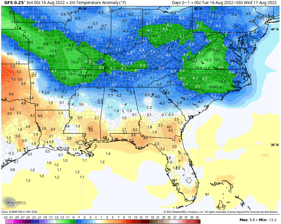
Over the next three days we’ll see a general cooling pattern across the Southeast as an upper-level low builds across the Great Lakes and Northeastern United States. For today, expect hot and muggy conditions for much of the Southeast, with the only exceptions being for portions of Kentucky, Tennessee, parts of Arkansas and northern Georgia, South Carolina and North Carolina. As we progress through the week, the boundary between these two air masses will continue to move further south, bringing much needed cooler temperatures all the way to the Gulf Coast by Thursday, in addition to an increase in shower and thunderstorm activity.
(adsbygoogle = window.adsbygoogle || []).push({});
Current Synoptic Picture

With an upper-level ridge occupying most of the Western United States at the moment, and an upper-level low in the east, the Southeastern United States is feeling the impacts from both features, with very hot temperatures for our western locations, and cooler and wetter conditions more toward our northern and eastern locations.
(adsbygoogle = window.adsbygoogle || []).push({});
Today’s Forecast
For today, above average temperatures can be expected for many locations across the Southeast, stretching from eastern Texas all the way into southern Georgia and Florida. The exception to this warmth is closer to the cooler air mass underneath the upper-level low, with places like Memphis, Little Rock and Nashville likely seeing below average temperatures today.

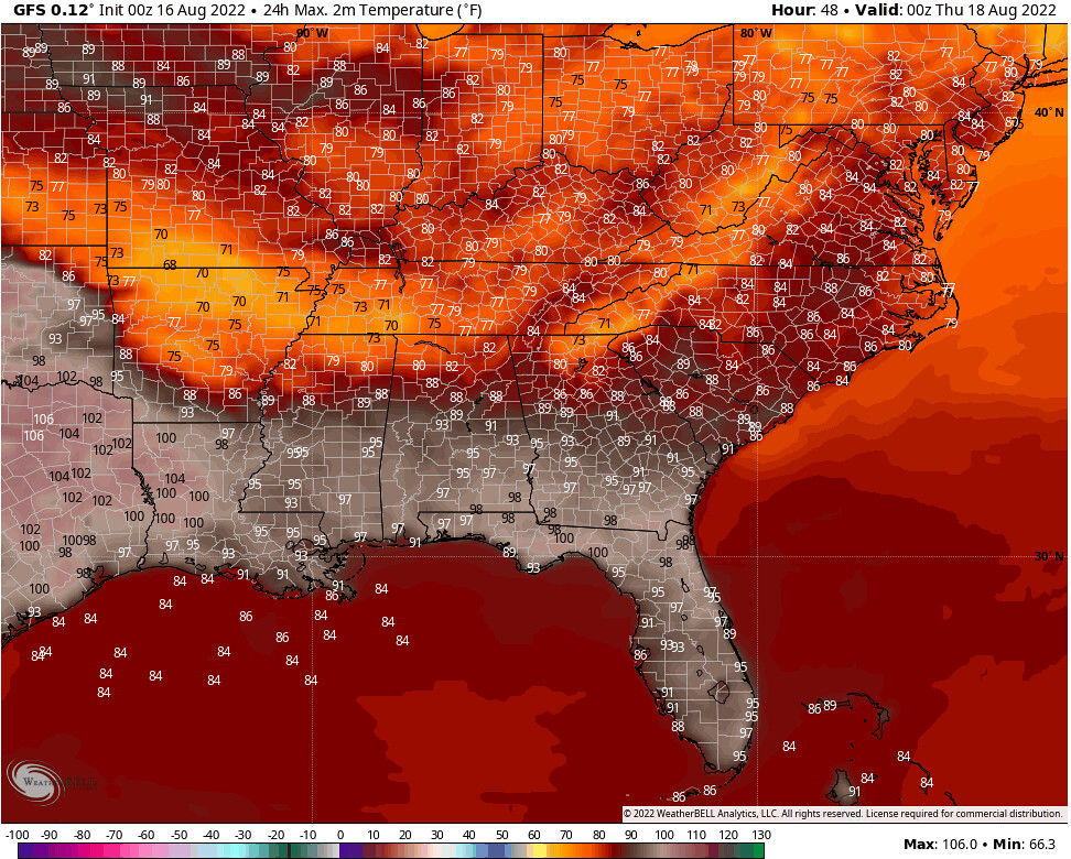
In our warmer regions, we can expect temperatures well into the 90s, even exceeding 100F in parts of Texas and northern Louisiana. Other than the strikingly hot high temperatures, another feature that sticks out in this high temperature map is the sharp cutoff between highs in the 90s, and highs in the low 80s – courtesy of an approaching boundary ahead of the cooler air that will be delivering some showers and thunderstorms to northern Mississippi, Alabama and Georgia, as well as parts of Arkansas and Tennessee.

(adsbygoogle = window.adsbygoogle || []).push({});
Boundary Continues to Push South through Friday
The story is much the same through Friday, as the boundary between these two air masses will continue to push south. This will lead to less coverage of the hot and muggy conditions by Wednesday, and even less by Thursday – as cooler temperatures are able to reach the Gulf Coast.


In addition to the expected cooldown that this approaching boundary will bring, it will also deliver an increase in shower and thunderstorm activity as it moves through and eventually stalls over the region, with the potential for some locations to receive several inches of rain through the next three days.

(adsbygoogle = window.adsbygoogle || []).push({});
3-Day Southeast City Forecast
| Dallas, TX | ||
| Tuesday | Wednesday | Thursday |
| High: 100F | High: 101F | High: 86F |
| Low: 81F | Low: 73F | Low: 71F |
| Precip.: None | Precip.: 30% | Precip.: 50% |
| Houston, TX | ||
| Tuesday | Wednesday | Thursday |
| High: 95F | High: 98F | High: 98F |
| Low: 80F | Low: 80F | Low: 79F |
| Precip.: None | Precip.: 20% | Precip.: 60% |
| New Orleans, LA | ||
| Tuesday | Wednesday | Thursday |
| High: 92F | High: 92F | High: 86F |
| Low: 81F | Low: 79F | Low: 77F |
| Precip.: 20% | Precip.: 30% | Precip.: 70% |
| Little Rock, AR | ||
| Tuesday | Wednesday | Thursday |
| High: 89F | High: 74F | High: 83F |
| Low: 71F | Low: 65F | Low: 65F |
| Precip.: 60% | Precip.: 90% | Precip.: 30% |
| Memphis, TN | ||
| Tuesday | Wednesday | Thursday |
| High: 83F | High: 77F | High: 83F |
| Low: 70F | Low: 65F | Low: 69F |
| Precip.: 50% | Precip.: 90% | Precip.: 20% |
| Birmingham, AL | ||
| Tuesday | Wednesday | Thursday |
| High: 91F | High: 82F | High: 82F |
| Low: 70F | Low: 67F | Low: 69F |
| Precip.: 20% | Precip.: 60% | Precip.: 40% |
| Atlanta, GA | ||
| Tuesday | Wednesday | Thursday |
| High: 86F | High: 80F | High: 78F |
| Low: 70F | Low: 69F | Low: 67F |
| Precip.: None | Precip.: 50% | Precip.: 50% |

