
I’m back with the memes! It’s a pretty accurate one as we’ll be getting some gusty winds for today and even on Friday. The main reason for this is the pressure gradient that is associated with the surface low pressure that brought the severe weather to us last night and is now moving towards the Atlantic coast. Some west northwest winds will be blowing with sustained winds around 10-15mph with 30mph wind gusts possible during the day and the overnight hours. We’ll reach the upper 50s during the day with the experienced temperature a bit lower due to the wind. Overnight, temperatures will reach the mid 30s with few clouds in the sky.
Thursday will be a brief period of light winds and pleasant conditions due to a moving surface high over the Deep South. Temperatures will reach the mid 60s with sunny skies. Overnight, the upper level clouds will begin to roll in and we’ll reach the low 40s overnight. For Friday, the surface high will move towards the southern Atlantic as a weak surface low moves through the Midwest creating another pressure gradient, this time moving Gulf moisture and southerly winds. These winds will be sustained at 5-10mph with wind gusts around 20. Upper level clouds will preside over the skies indicating the rain coming on Saturday. Highs will be in the low 70s and lows in the 50s.
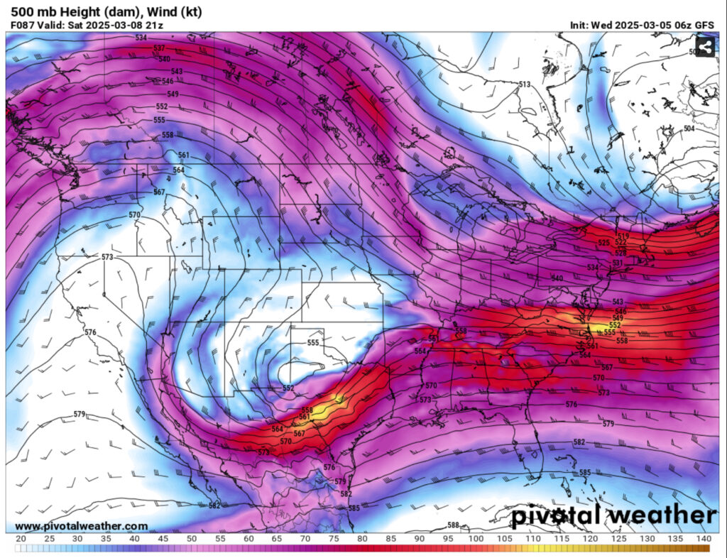
Saturday is still a bit of a mixed bag with models still out to lunch on where most of the rain will be and how much we will receive. It’s an even divide with the GFS, Euro, Canadian, and UK models all split on where the rain will be. The GFS places the rain directly over the coast to central Mississippi while the Euro splits it between south Louisiana and north central Mississippi. Either way, we’ll likely receive some amount of rain on Saturday afternoon into the evening hours. Severe parameters are limited, however I think some thunderstorms may develop with heavy rain and some gusty winds possible and maybe a some hail. The Skew-T’s show a dry slot in the mid to upper levels that could support that development, but it may be limited.
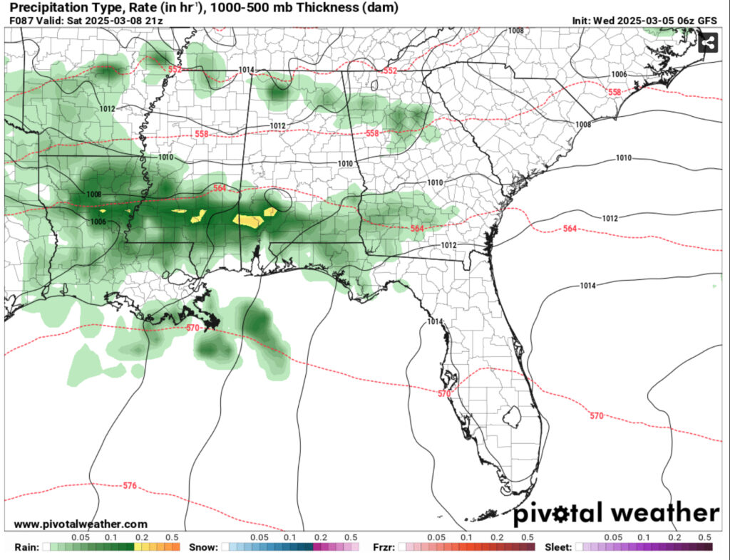
Just to reiterate the differences in model output, the GFS currently has precipitation totals around an inch across the Pinebelt while the Euro model barely puts us at a quarter of an inch. It’ll be something to watch out for in the next few days as the models (hopefully) de-amplify. I think that we’ll see rain either way and cloudy skies will be the main weather we’ll see.
As the rain moves out, Sunday will be a bit cooler with the low pressure zone moving towards Alabama and Georgia. This will bring in some more western and later, northwest winds. Some of the winds will be gusting into the upper teens to low 20s. Low level stratus clouds will likely be keeping some of the sunshine away during the day, and it will move out overnight.
To start off the week, another surface high pressure will move in to the Deep South and bring in some warmer air to us. For the next few days, we’ll have winds calm on Monday with highs in the upper 60s and lows in the low 40s. Tuesday will be warmer with sunny skies and temperatures in the low 70s and lows in the low 40s. As the winds shift towards the south again due to another low pressure in the Great Lakes, we’ll reach the low 70s on Wednesday with temperatures cooling off in the afternoon. Overnight, we’ll only reach the upper 50s with southwesterly winds.
Regional Day-to-Day Forecast
Today – Sunny, with a high in the upper 50s. West wind 15 to 20 mph, with gusts as high as 30 mph.
Tonight – Clear, with a low in the mid 30s. West northwest wind 5 to 15 mph, with gusts as high as 30 mph.
Thursday – Sunny, with a high in the low 60s. North northwest wind around 5 mph becoming calm in the afternoon.
Thursday Night – Partly cloudy, with a low in the low 40s. Calm wind.
Friday – Mostly sunny, with a high in the mid 70s. Light south southeast wind becoming south 10 to 15 mph in the morning. Winds could gust as high as 20 mph.
Friday Night – Partly cloudy, with a low in the mid 50s. South wind 5 to 10 mph becoming light and variable after midnight. Winds could gust as high as 20 mph.
Saturday – A chance of showers and thunderstorms, then showers likely and possibly a thunderstorm after noon. Partly sunny, with a high in the mid 70s. Light and variable wind becoming northeast 5 to 10 mph in the morning. Chance of precipitation is 60%.
Saturday Night – Showers likely and possibly a thunderstorm before midnight, then a chance of showers. Mostly cloudy, with a low around 50. North wind 5 to 10 mph. Chance of precipitation is 60%.
Sunday – Partly sunny, with a high in the mid 60s. North wind 5 to 10 mph, with gusts as high as 20 mph.
Sunday Night – Partly cloudy, with a low in the low 40s.
Monday – Sunny, with a high near 70.
Monday Night – Mostly clear, with a low in the low 40s.
Tuesday – Sunny, with a high in the mid 70s.


