If you’ve been saying, “Man, it’s dry!” you’d be right. Looking back through the archives of the Drought Monitor, this is the worst drought for the region since September of 2000.

By coincidence, that was also the end of the last “Triple Dip” La Nina. Though, in 2000, we didn’t flip back to an El Nino until mid-2002. This year we flipped back to an El Nino back in April of this year.
Here is a look at the latest Drought Monitor:


Much of southern Louisiana is in D3 or D4 drought, while southern Mississippi is the same. Alabama is fairing a bit better, but still has some D2 and D3 drought for lower Alabama.
PRECIP SINCE JANUARY
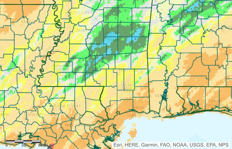
Looking at the amount of precipitation since the start of the year you can see when the lack of rain started. Keeping with the key on the left side, anything between yellow and light green is – generally – okay with rainfall. You aren’t meaningfully above or below normal. But when you start to drift into the darker greens and blues, you start to see too much rain and then, concversely, once you drop into the browns and reds, you are far too dry. Aside from a damp April, we’ve been generally dry since February. And then things really took off this Summer with the big ridge of high pressure parked on top of us.


Exacerbating the lack of rain has been the very warm temperatures and the lower-than-normal humidity. Both factors mean we are pulling more water out of the soil than normal – on top of the lack of rainfall.
So, the ground is currently parched.
SOME SMALL IMPROVEMENT COMING
Rainfall during the last 7 days has helped parts of Louisiana and Alabama, but for everyone in the middle – its been (in spots) bone dry.

And during the next 10 days, there won’t be much – if any – help according to the operational model guidance.


Some good news is that as we move into October (the driest month of the year, historically) it does look like we will have a few chances for some rain. Not a lot of rain, nor enough to put a big dent in the drought… But some rain.
CLOSING OUT 2023
More good news is that El Nino October-through-December time periods tend to be “wetter than normal” for the region.

The only asterisk to that is that droughts that are fully entrenched (like this one) are often tough to break. It often takes “a flood” to turn the table. The hope is that we can piece-by-piece catch back up on rainfall for the region, but be aware that we may not rebound from this drought uniformly – both geographically and temporarily.
In the meantime, hang in there. I know for a lot of farmers this has been a brutal Summer. And for gardeners it has been very, very frustrating. But if history tells us anything, we should start to turn things around through the end of the year and should be back to “normal” by next growing season.


What we need here in South MS is a tropical system like Harold that went into northern Mexico, dumped 2 to 4 inches over a day or 2 but kept going.