Since the cold air has descended across parts of the South again, I wanted to break out my handy “Will it Snow?” graphic. And I wanted to walk through two quick examples showing why it can snow in these types of situations as well as why – most times – it can’t snow.
This is a quick plinko-style guide to seeing if it will snow near you!

This is a simplified guide, though. There are a handful of other factors that go into whether or not it will snow for you, but this is a great starter. So let’s take a look at some data and go down the Plinko!
Finding Wintry Precip

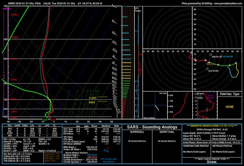
Above is a forecast sounding from northern Mississippi from early Tuesday morning. Let’s go through the guide!
Step 1:
Moisture? Yes! Some!
Step 2:
Forcing? Yes… barely. But it counts!
Omega? Yes, in the mid-levels, and specifically in the Dendritic Growth Zone.
Step 3:
Dry Air? Not much, but it certainly isn’t “moist” either. I think “Sorta” would be best here.
Step 4:
Warm Air layer? Nope! Below 32F the whole way down!
Step 5:
Precipitating? Flurries!
Not Finding Wintry Precip
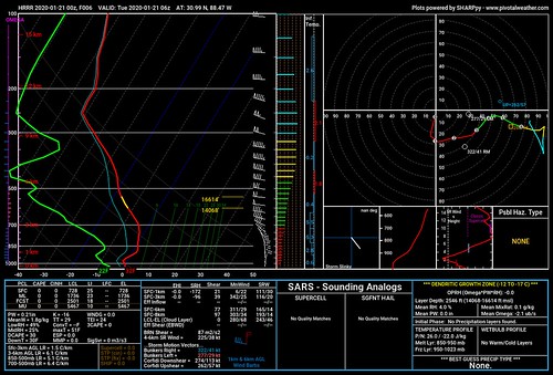
Meanwhile further south, it is a different story.

We can go through the same steps here, and we come up with a much different outcome.
Step 1:
Moisture? None.
Step 2:
Forcing? Yes… barely. But it counts!
Omega? Yes, in the mid-levels, and specifically in the Dendritic Growth Zone.
Step 3:
Dry Air? A ton. The temperature-dew point spread is very large through the column.
Step 4:
Warm Air layer? Between about 1200ft and 2400ft the temperature is above freezing.
Step 5:
Precipitating? Nope. And even if it did, it would be a Wintry Mix, not full blown snow.

