8/22/15 UPDATE: For the latest on Danny CLICK HERE
8/21/15 ORIGINAL: Danny is now a Three. The Hurricane Hunters relayed data to the National Hurricane Center during their investigation of Danny Friday showing that winds increased to 115mph.
Here is the official update from the National Hurricane Center:
HURRICANE DANNY TROPICAL CYCLONE UPDATE
NWS NATIONAL HURRICANE CENTER MIAMI FL AL042015
200 PM AST FRI AUG 21 2015…NOAA HURRICANE HUNTER AIRCRAFT REPORTS THAT DANNY IS A MAJOR
HURRICANE…Reports from a NOAA Hurricane Hunter aircraft indicate that Danny is now a Category 3 Hurricane on the Saffir-Simpson Hurricane Wind Scale. The maximum winds are estimated to be 115 mph (185 km/h) with higher gusts.
No additional intensification is expected, as Danny is moving into an area of unfavorable upper-level winds, and a weakening trend is expected to begin later today. Consequently, no adjustment to the forecast intensities from the previous advisory is required.
SUMMARY OF 200 PM AST…1800 UTC…INFORMATION
———————————————-
LOCATION…14.3N 48.6W
ABOUT 900 MI…1450 KM E OF THE LEEWARD ISLANDS
MAXIMUM SUSTAINED WINDS…115 MPH…185 KM/H
PRESENT MOVEMENT…WNW OR 290 DEGREES AT 10 MPH…17 KM/H
MINIMUM CENTRAL PRESSURE…974 MB…28.76 INCHES
The Hurricane Center is still forecasting Danny to weaken during the next 36 hours, but a Category 3 storm was not what most meteorologists were anticipating.
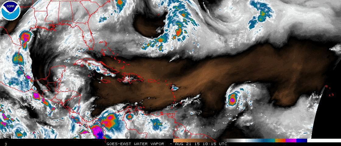
As shown above, Danny will have to enduring a lot of dry air (outlines in orange on the map) and some wind shear (not shown above). This will likely help to weaken the storm in the coming days. Also, the storm is forecast to travel over Puerto Rico, the Dominican Republic, Haiti and eventually Cuba. This much time over land and battling some of the low – but still meaningful – mountains of those islands will also help to weaken the hurricane.
Other Danny satellite loopsThe Antilles Islands may not be so lucky, as the storm is forecast to be a Category 1 or higher storm as it moves across the islands that separate the Caribbean and Atlantic.
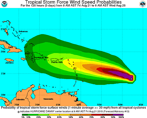
Here is a look at what the National Hurricane Center expects in the next 120 hours:
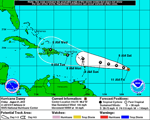
The forecast track of Danny has, so far, been quite accurate. The National Hurricane Center hasn’t budged much on the forecast and Danny has been scooting – slowly – right along the projected path.
Here is a look at the current forecast path:
More details to come!


