There is at least one forecast that is a promise: Disappointment.
The Reality: This is Tough
Starting late Thursday, through Friday and into Saturday there will be a really good chance that many parts of the south will be cold. Quite cold. There is a slightly lower chance that these same areas will have precipitation possible at the same time as the cold air oozes into the area.
The chance that the precipitation falls as snow depends on (1) where you are, (2) where the area of lowest pressure moves, (3) how fast the cold air pushes south, (4) how deep the cold air is, (5) the direction vector of the moisture plume, (6) if the over-riding southwest flow is moist enough at the right levels, (7) if the dendritic growth zone can become saturated, and (8) the wet-bulb temperature through the profile.
As well as a handful of other factors like (9) 500mb vorticity location, (10) 700mb vertical velocity, and (11) 200mb divergence.
Oh, and (12) if all of these things can happen in the (12a) right amounts (12b) at the right time (12c) in the right place and (12d) you are in that place and (12e) looking for it.
So you can imagine, as a meteorologist, how I am preparing to be “wrong” for everyone. Literally. Every. One.
But that is forecasting wintry weather in the South. It is difficult. And forecasting for the public is taking a highly variable mathematical equation with multiple outcomes and turning it into a deterministic forecast with one outcome, for everyone.

The Modeling
There are a lot of model outputs floating around social media media. Because weather data is free to find on the web, people find it. And post it. So here are some of the successive model runs from the GFS during the last 48 hours regarding freezing rain accumulation.
WARNING: Model data is guidance, not Gospel. Not a single one of these is 100% accurate. And when looking at precip output, it can be deceiving because models don’t do the best job with realizing precip totals.
Hat tip to the guys at Pivotal Weather for allowing us to use their model data.
There is a trend here, though, that the chance for freezing rain appears to be increasing. But look at the thin line of accumulation on all of these. Less than 0.10″ on a streak that is no more than about 20 miles wide north-to-south. Regardless of where it happens, the likelihood of it being widespread is quite low.

And freezing rain is the most likely scenario for much of The South as it involves cold air at the surface, with a plume of warm air in the mid levels with a moist column and precip.
Lately, I might sound like a “Negative Nancy” when it comes to wintry precip forecasting but when the “most likely” thing is only spitting out less than 0.10″ of precip, I try my best to temper expectations.
I know everyone wants snow. Snow is fun! I love snow! I’d love to see some, too. But, its tough to get down here. There’s a chance, but it is pretty small.
I suppose I am. Okay, let’s get nerdy and take a look at the modeling…
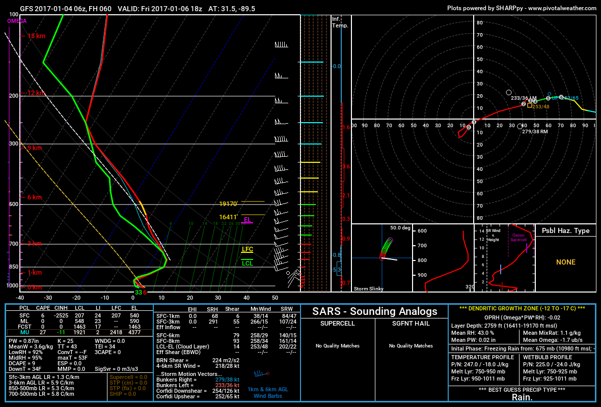
Here is a look at what the 6z GFS thinks our atmosphere will look like across south Mississippi late Friday afternoon.
If you need a refresher on reading a Skew T, check this out! For how it relates to snow, check this out!
There a couple of BIG things to notice.
(1) The DGZ (the yellow line on the red line, in this case around 600mb) isn’t saturated
(2) There is a warm nose around 850mb
(3) While just above the surface the temperature is below freezing, the temperature at the surface will be above freezing
(4) The sounding is already saturated below 700mb so “wet-bulbing” isn’t going to help as much.
When the DGZ isn’t saturated, it becomes more difficult to create snowflakes. Not impossible, but more difficult. Even if we can make snowflakes, the warm nose around 850mb would melt the snowflakes as they fell. Those melted snowflakes would then refreeze above the surface, but then re-melt just above us and fall as rain. Because the sounding is saturated with moisture already, the falling rain wouldn’t help cool down the column of air allowing the snow to stay as snow.
That sounding is going to be accurate on Friday for everyone south of a line from roughly Alexandria, LA to Atlanta, GA.
When does that change? Saturday morning by 7am. That above mentioned line gets squashed down about 50 miles south and closer to the Gulf Coast.
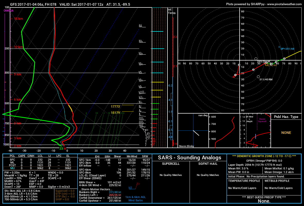
Well, lets look at the same four things.
(1) The DGZ (the yellow line on the red line, in this case around 600mb) isn’t saturated – it is VERY dry here
(2) The warm nose is gone around 850mb
(3) The surface temperature is well below freezing
(4) The sounding isn’t saturated, but because it is below freezing through the column that is less important.
But here is the biggest problem, now we may have run out of moisture to precipitate. So let’s see if we can find any.
The 500mb vorticity, 700mb vertical velocity and 850mb relative humidity maps will help us find if we can take any of the moisture at 850, move it up through the 700 layer due to energy at 500.
Well, while we have the energy at 500mb, we don’t see much vertical velocity left over at 700mb and the moisture in the 850mb layer isn’t great. So while there is a chance for widespread snow south of a line from Lafayette, LA to Columbus, GA, it certainly isn’t great. Certainly not set up for any accumulation.
Localized areas may see some snow in the air, and a few spots may even see a brief dusting, too. So while you may see some snowflakes, your friend across town might only get rain. And that might be how crazy close it gets.
What Concerns Me
As the rain ends and the cold air sneaks in, there may be a brief window of opportunity for the rain to switch to freezing rain. And for the water already on the ground to start to freeze.
That means, if you are traveling late Friday or early Saturday, you may be driving on wet roads that can turn icy in the blink of an eye.
If you are traveling during that time period, please be careful!
The good news is that the cold air will be quite dry, so any water left over on the roads will evaporate pretty quickly once the rain ends. But during that window where it is cold AND water is still on the ground, please be careful
Bottom Line
Let’s not forget how cold it is going to be Saturday and Sunday nights. Latest model trends continue to suggest that lows in the 20s will be possible across the south. Even the teens for a few low-lying spots.
If you live south of I-20, prepare for the cold air, the cold rain, and the possibility for the cold rain to turn to freezing rain for a brief period of time. And hope to get lucky enough to see some sleet or even some snowflakes, but that is about it.
If you live north of I-20, you have a better chance for seeing snow – but any accumulation will be pretty light. Most models don’t show enough ‘juice’ to offer more than an inch for most places.
And that is disappointing to hear, I know. For everyone.


